- My Forums
- Tiger Rant
- LSU Recruiting
- SEC Rant
- Saints Talk
- Pelicans Talk
- More Sports Board
- Coaching Changes
- Fantasy Sports
- Golf Board
- Soccer Board
- O-T Lounge
- Tech Board
- Home/Garden Board
- Outdoor Board
- Health/Fitness Board
- Movie/TV Board
- Book Board
- Music Board
- Political Talk
- Money Talk
- Fark Board
- Gaming Board
- Travel Board
- Food/Drink Board
- Ticket Exchange
- TD Help Board
Customize My Forums- View All Forums
- Show Left Links
- Topic Sort Options
- Trending Topics
- Recent Topics
- Active Topics
Started By
Message
re: Severe Weather for Friday
Posted on 4/8/21 at 1:16 pm to NorthEndZone
Posted on 4/8/21 at 1:16 pm to NorthEndZone
quote:
...Southeastern Great Plains into central Gulf States...
While there appears reasonable model consensus on the general
large-scale pattern evolution, considerable spread does exist
concerning the synoptic and, particularly, the sub-synoptic
developments for this period. Given moistening low-levels in the
presence of steepening mid-level lapse rates, it does appear that
substantial mixed-layer CAPE could develop Friday, in the presence
of strong vertical shear. This provides support for the risk of
severe storm development, though the extent and focus/details remain
unclear at the present time. Based on the latest guidance, there
does appear potential for the evolution of multiple clusters of
severe storms Friday and Friday night, with isolated to widely
scattered discrete supercell development also possible.
There does appear a consistent signal in the model output that
large-scale ascent along a strengthening mid-level baroclinic zone
may provide support for increasing thunderstorm development across
the Ark-La-Tex vicinity through southern Arkansas by mid day Friday.
As the boundary-layer destabilizes, there appears potential for
this activity to evolve into an intensifying and organizing
mesoscale convective system, which will tend to advect/propagate
eastward across the north central Mississippi/Alabama vicinity
before weakening Friday evening.
The approach of the southern mid-latitude/subtropical Pacific
impulse may contribute to renewed thunderstorm development upstream,
along the trailing convective outflow, by Friday evening. This may
evolve into another organizing cluster of severe storms, which will
probably tend to develop east-southeastward across the lower
Mississippi Valley through early Saturday.
Given the steep mid-level lapse rates, sizable CAPE and strong
shear, stronger initial storm development may be accompanied by the
risk for large, damaging hail, before activity grows upscale with
damaging wind gusts becoming the more prominent hazard, along with
the possibility of a few tornadoes.
..Kerr.. 04/08/2021
 2
2

Posted on 4/8/21 at 1:39 pm to NorthEndZone
I like "discreet supercells, explosive updrafts, and giant hail" better if we are going for maximum effect.
Posted on 4/8/21 at 1:51 pm to Paul Allen
quote:
But why you got to be an a-hole?
It's his nature.
Hail transitioning to a spicy line of storms is the story tomorrow. Those early hailers, going to be watching for lightning. Lots of lightning will mean a lot of ice up in the clouds.
Posted on 4/8/21 at 2:03 pm to Duke
3K NAM showing a hell of a line:
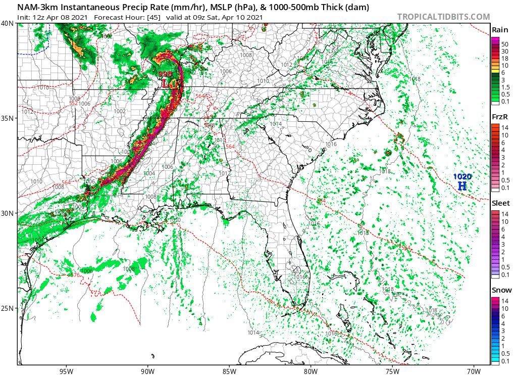
Posted on 4/8/21 at 2:07 pm to LegendInMyMind
The soundings out in front are impressive too, especially in the time frame you posted. Strong low-level winds in a dry slot aloft will transport that wind to the surface. The bowing sections will be rocking and there will certainly be quick spin ups in that line.
Posted on 4/8/21 at 2:26 pm to Duke
Guy on the weather channel just said the hail in Dallas could be as big as hen eggs. Hope y’all got insurance
Posted on 4/8/21 at 2:27 pm to Duke
There's alot of fuss right now on WXTwitter about the SPC Probability Outlooks. Alot of folks are questioning the higher emphasis on hail and wind over tornado. I think it is a pretty safe bet that those two are the more likely to verify, especially over the larger area. It isn't like they are saying there is a 0% chance of tornadoes.
And many of them are currently mourning the loss of the "goldfish" Enhanced Risk area from this morning.
And many of them are currently mourning the loss of the "goldfish" Enhanced Risk area from this morning.
Posted on 4/8/21 at 2:28 pm to LegendInMyMind
How is this going to impact bsb games starting at 6 in Mississippi?
Posted on 4/8/21 at 2:28 pm to Yancy turnip
quote:
Guy on the weather channel just said the hail in Dallas could be as big as hen eggs. Hope y’all got insurance
It is East Texas. Hen eggs is probably a conservative estimate.
Posted on 4/8/21 at 2:28 pm to Yancy turnip
quote:
Guy on the weather channel just said the hail in Dallas could be as big as hen eggs. Hope y’all got insurance
hen eggs
that's a new 1 on me
Posted on 4/8/21 at 2:33 pm to LegendInMyMind
quote:
And many of them are currently mourning the loss of the "goldfish" Enhanced Risk area from this morning.
We all know that wasn’t a goldfish.
Posted on 4/8/21 at 3:03 pm to NorthEndZone
Tennis ball hail possible

Posted on 4/8/21 at 3:13 pm to Lsuhoohoo
I wonder if this gets an upgrade to moderate by morning

Posted on 4/8/21 at 3:42 pm to deltaland
For Alabama this is going to be one of those confusing events where there is an enhanced risk in west Alabama on the Friday outlook but the main severe threat actually comes on Saturday morning. The Friday outlook is valid until 7am CT on Saturday morning, so it covers the severe threat through that time.
This post was edited on 4/8/21 at 3:43 pm
Posted on 4/8/21 at 3:44 pm to deltaland
quote:
I wonder if this gets an upgrade to moderate by morning
If it does, it would likely be a wind driven upgrade rather than a tornado driven one. A wind based moderate risk is pretty rare in this part of the country.
Posted on 4/8/21 at 4:08 pm to Roll Tide Ravens
quote:
If it does, it would likely be a wind driven upgrade rather than a tornado driven one. A wind based moderate risk is pretty rare in this part of the country.
Derecho is starting to be discussed, and with the looks of that line, it may be warranted. Those are tough parameters to meet, though.
Posted on 4/8/21 at 4:10 pm to Roll Tide Ravens
quote:
For Alabama this is going to be one of those confusing events where there is an enhanced risk in west Alabama on the Friday outlook but the main severe threat actually comes on Saturday morning.
How's the AL Gulf Coast looking for Fri/Sat? Thanks
Posted on 4/8/21 at 4:15 pm to Palmetto08
quote:
How's the AL Gulf Coast looking for Fri/Sat? Thanks
Windy and rainy at times.
Posted on 4/8/21 at 4:22 pm to LegendInMyMind
quote:
Derecho is starting to be discussed, and with the looks of that line, it may be warranted. Those are tough parameters to meet, though.
I doubt it'll hit the mark in length of time but when the line gets together, it'll probably produce those kind of winds but the threat seems to wane as it marches east into the night. The low level winds drop some as the night goes on.
Posted on 4/8/21 at 4:47 pm to LegendInMyMind
A strong derecho can be worse than a tornado outbreak because it covers so much area. Remember that one last year in Iowa

 Page 13 of 28

Popular
Back to top