




 0
0







- My Forums
- Tiger Rant
- LSU Recruiting
- SEC Rant
- Saints Talk
- Pelicans Talk
- More Sports Board
- Fantasy Sports
- Golf Board
- Soccer Board
- O-T Lounge
- Tech Board
- Home/Garden Board
- Outdoor Board
- Health/Fitness Board
- Movie/TV Board
- Book Board
- Music Board
- Political Talk
- Money Talk
- Fark Board
- Gaming Board
- Travel Board
- Food/Drink Board
- Ticket Exchange
- TD Help Board
Customize My Forums- View All Forums
- Show Left Links
- Topic Sort Options
- Trending Topics
- Recent Topics
- Active Topics
Started By
Message
Posted on 4/18/19 at 10:37 am to LSUJuice
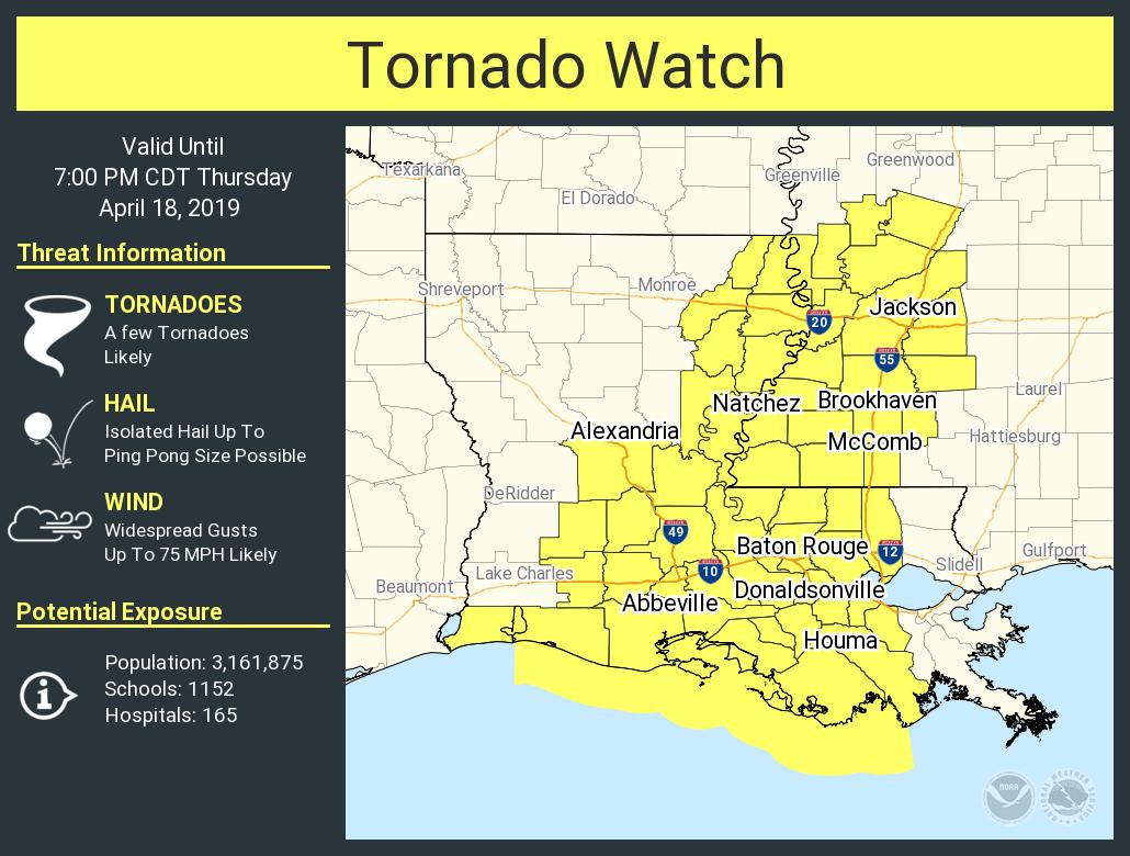
tornado watch officially issued
Posted on 4/18/19 at 10:39 am to rt3
My parish was left out of that, so I got that going for me.
Posted on 4/18/19 at 10:41 am to TigerStripes06
WAFBweather
?
Verified account
@WAFBweather
1m1 minute ago
More
The NWS Storm Prediction Center has just issued a Tornado Watch for the entire viewing area until 7PM. Remember a Tornado Watch means conditions are favorable for the development of tornadoes. A Tornado Warning means a tornado is either confirmed or possibly detected by radar.

?
Verified account
@WAFBweather
1m1 minute ago
More
The NWS Storm Prediction Center has just issued a Tornado Watch for the entire viewing area until 7PM. Remember a Tornado Watch means conditions are favorable for the development of tornadoes. A Tornado Warning means a tornado is either confirmed or possibly detected by radar.
Posted on 4/18/19 at 10:41 am to NorthEndZone
This storm is going to frick with my weekend road trip bad. High temps are gonna be 30 degrees lower on Saturday than they are today. 
Posted on 4/18/19 at 10:42 am to GetCocky11
Mother Nature gives zero f@cks.
Posted on 4/18/19 at 10:42 am to Tester1216
quote:
Mother Nature gives zero f@cks.
Oh I know. The day after I leave, temps will be back up in the high 70s.
Mother Nature is a cruel bitch.
Posted on 4/18/19 at 10:43 am to rt3

quote:
URGENT - IMMEDIATE BROADCAST REQUESTED Tornado Watch Number 82 NWS Storm Prediction Center Norman OK 1035 AM CDT Thu Apr 18 2019 The NWS Storm Prediction Center has issued a * Tornado Watch for portions of Louisiana Western Mississippi Coastal Waters * Effective this Thursday morning and evening from 1035 AM until 700 PM CDT. * Primary threats include... A few tornadoes likely with a couple intense tornadoes possible Widespread damaging winds likely with isolated significant gusts to 75 mph possible Isolated large hail events to 1.5 inches in diameter possible SUMMARY...Clusters of strong thunderstorms are expected to intensify by early afternoon and spread east-northeast across the Lower Mississippi Valley. Tornadoes and damaging winds are the primary hazards. The tornado watch area is approximately along and 65 statute miles east and west of a line from 20 miles southeast of Intracoastal City LA to 95 miles north northeast of Natchez MS. For a complete depiction of the watch see the associated watch outline update (WOUS64 KWNS WOU2). PRECAUTIONARY/PREPAREDNESS ACTIONS... REMEMBER...A Tornado Watch means conditions are favorable for tornadoes and severe thunderstorms in and close to the watch area. Persons in these areas should be on the lookout for threatening weather conditions and listen for later statements and possible warnings. && AVIATION...Tornadoes and a few severe thunderstorms with hail surface and aloft to 1.5 inches. Extreme turbulence and surface wind gusts to 65 knots. A few cumulonimbi with maximum tops to 500. Mean storm motion vector 21030.
Posted on 4/18/19 at 10:45 am to Tester1216
quote:
Mother Nature gives zero f@cks.
It's not a living being. It has no emotions.
Posted on 4/18/19 at 10:45 am to MorbidTheClown
If I have to go to the wank at 1, how are my prospects looking? Should I be watching for falling trains on the Huey P?
Posted on 4/18/19 at 10:45 am to weadjust
That's actually an older outlook. The 1300z sig outlook was trimmed back just a bit towards the north and east.
Posted on 4/18/19 at 10:45 am to Hammertime
quote:
Should I be watching for falling trains on the Huey P?
i would be.
Posted on 4/18/19 at 10:47 am to TigerstuckinMS
quote:
medicine ball sized hail
Is this a new OT joke?
Posted on 4/18/19 at 10:47 am to Hammertime
quote:
Should I be watching for falling trains on the Huey P?
always a good severe weather gif

Posted on 4/18/19 at 10:47 am to Hammertime
quote:
If I have to go to the wank at 1, how are my prospects looking? Should I be watching for falling trains on the Huey P?
If you’re going to the Wank you have more dangerous things to worry about other than falling trains
Posted on 4/18/19 at 10:47 am to WoWyHi
Stop being logical 
Stay safe my friend.
Stay safe my friend.
Posted on 4/18/19 at 10:49 am to TigerstuckinMS
quote:
Are we up to medicine ball sized hail yet?
10lb, 14lb or 20lb?
That’s the difference between life and death
Posted on 4/18/19 at 10:49 am to Hammertime
quote:
If I have to go to the wank at 1, how are my prospects looking?
Odds are pretty high you will die in a car wreck caused by a texting or drunk driver
Posted on 4/18/19 at 10:50 am to Tester1216
Stay thirsty, mi amigo.

 Page 34 of 69



Popular

Back to top
 Follow TigerDroppings for LSU Football News