- My Forums
- Tiger Rant
- LSU Score Board
- LSU Recruiting
- SEC Rant
- SEC Score Board
- Saints Talk
- Pelicans Talk
- More Sports Board
- Coaching Changes
- Fantasy Sports
- Golf Board
- Soccer Board
- O-T Lounge
- Tech Board
- Home/Garden Board
- Outdoor Board
- Health/Fitness Board
- Movie/TV Board
- Book Board
- Music Board
- Political Talk
- Money Talk
- Fark Board
- Gaming Board
- Travel Board
- Food/Drink Board
- Ticket Exchange
- TD Help Board
Customize My Forums- View All Forums
- Show Left Links
- Topic Sort Options
- Trending Topics
- Recent Topics
- Active Topics
Started By
Message
re: Sally - Moving towards Georgia - Potential for Significant Flooding
Posted on 9/13/20 at 10:54 am to slackster
Posted on 9/13/20 at 10:54 am to slackster
quote:What is a good metaphor for those of us who don't study astrology? Why are circulations treated as separate?
Low level center is still misaligned from the mid level center based on the most recent recon pass
 4
4

Posted on 9/13/20 at 10:54 am to Thib-a-doe Tiger
quote:
And y’all said a 50 mile miss was bad in the Laura thread, so we’re on the doorstep of a bad miss inside 48 hours
69 nautical miles is a one standard deviation miss at 48 hours. This is/was well inside of that sized move.
Posted on 9/13/20 at 10:54 am to TypoKnig
quote:Definitely uppercase.
Uppercase or lowercase?
Posted on 9/13/20 at 10:56 am to EXPLAYER
quote:
EXPLAYER
Is your name Roger by chance?

Posted on 9/13/20 at 10:56 am to TheFonz
quote:Duke or some of the others will know if anyone does. If Peej says he does just go outside and piss in the wind direction.
Okay stupid question from a weather idiot.quote:
Reserved for Peej PUNK!!!!!
Does anyone know of a resource online that updates with the tracks they may give a general idea of projected wind speeds in a given area like Covington/Mandeville? Wind will be my biggest issue. I see sometimes the news channels do it but was wondering if it was online somewhere.
This post was edited on 9/13/20 at 11:01 am
Posted on 9/13/20 at 10:56 am to Jake88
quote:
What is a good metaphor for those of us who don't study astrology? Why are circulations treated as separate?
Think of the water draining in your bathtub. As it starts to swirl like a tornado, it can’t really get going until the “swirl” is stacked from the top of the water to the bottom of the drain, then it takes off. If you push the water, it messes up the vertical stack and the tornado takes a moment to realign itself before it can get going again.
ETA- this is a terrible analogy for physics reasons but a good one for a visual aid of what’s happening.
This post was edited on 9/13/20 at 10:59 am
Posted on 9/13/20 at 10:58 am to TypoKnig
quote:
And this is due in part to the western wind shear? If so, I’m guessing these centers will become more aligned and therefore be favorable for strengthening once the shear subsides?
Basically. The wind changes direction with height above the surface. That change is pushing convection off of the low level center of circulation.
Posted on 9/13/20 at 10:58 am to Jake88
quote:
What is a good metaphor for those of us who don't study astrology?

Posted on 9/13/20 at 10:59 am to Jake88
quote:
What is a good metaphor for those of us who don't study astrology? Why are circulations treated as separate?
A hurricane basically takes water vapor (heat) and turns it into wind. It does this far more efficiently when the circulation is aligned vertically.
The circulations are part of the same system but misaligned. When they stack up, a storm can strengthen toward hurricane strength.
Posted on 9/13/20 at 11:01 am to slackster
I was thinkimg like that, but it makes the circulation seems as a whole, whereas, talk of upper, mid and lower level circulation make a hurricane seem more fragmented. I gather because of the heights involved there is a great deal of variables that could affect one level of circulation but not the other. Where is the shear located? What causes the levels to become columnar in the funnel besides the Earth's rotation?
Posted on 9/13/20 at 11:02 am to Duke
Thanks. When I read Isaac's Storm, it did a nice explanation of how the storm forms. I just haven't read up much on levels of circulation.
Posted on 9/13/20 at 11:02 am to Roll Tide Ravens
my friend I'll be praying for those rain totals. thank you for that
Posted on 9/13/20 at 11:02 am to Duke
quote:
A hurricane basically takes water vapor (heat) and turns it into wind. It does this far more efficiently when the circulation is aligned vertically.
The circulations are part of the same system but misaligned. When they stack up, a storm can strengthen toward hurricane strength.
It’s basically summarized as the shorter the route to the upper atmosphere, the more efficient it can be. If it has to travel at an angle to escape through the mid level center, it’s not as quick and efficient as a straight line from the ocean to the heavens.
Posted on 9/13/20 at 11:03 am to GEAUXT
Well, we can all be rocket meteorologists.
Posted on 9/13/20 at 11:04 am to slackster
So tornadoes that appear serpentine are generally weaker than the straight vertical ones?
Posted on 9/13/20 at 11:05 am to LSURussian
I heard yesterday 68K remain without power per local news.

Posted on 9/13/20 at 11:06 am to Jake88
Mike Seidel is probably the only person in Gulf Shores wearing a mask.
Posted on 9/13/20 at 11:07 am to Jake88
quote:
When I read Isaac's Storm, it did a nice explanation of how the storm forms. I just haven't read up much on levels of circulation.
Good book.
The levels of circulation are something I'd be happy to expand on later.

Posted on 9/13/20 at 11:08 am to Duke
Levi
quote:
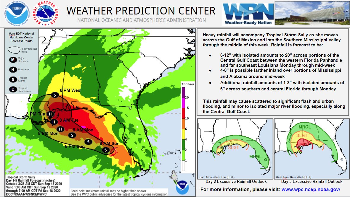
There is much talk about exactly how strong #Sally's winds get, but the biggest impact for many will be flash flooding & river flooding due to heavy rainfall near & east of landfall as Sally moves slowly. This will extend well into AL and FL even if the eye doesn't landfall there

 Page 63 of 298

Popular
Back to top