- My Forums
- Tiger Rant
- LSU Recruiting
- SEC Rant
- Saints Talk
- Pelicans Talk
- More Sports Board
- Fantasy Sports
- Golf Board
- Soccer Board
- O-T Lounge
- Tech Board
- Home/Garden Board
- Outdoor Board
- Health/Fitness Board
- Movie/TV Board
- Book Board
- Music Board
- Political Talk
- Money Talk
- Fark Board
- Gaming Board
- Travel Board
- Food/Drink Board
- Ticket Exchange
- TD Help Board
Customize My Forums- View All Forums
- Show Left Links
- Topic Sort Options
- Trending Topics
- Recent Topics
- Active Topics
Started By
Message
re: Nasty tornado on the ground in Lee County, AL (Now rated EF4)
Posted on 3/3/19 at 2:56 pm to Roll Tide Ravens

Posted on 3/3/19 at 2:56 pm to Roll Tide Ravens
The velocity couplet on the second Lee County storm does not look as good now, but there is still a TDS. Of course, it takes a while for all of the debris to fall back down once the tornado lifts.
 1
1

Posted on 3/3/19 at 2:57 pm to rds dc
SPC getting detailed

Mesoscale Discussion 0150
NWS Storm Prediction Center Norman OK
0251 PM CST Sun Mar 03 2019
Areas affected...central GA
Concerning...Tornado Watch 8...
Valid 032051Z - 032115Z
The severe weather threat for Tornado Watch 8 continues.
SUMMARY...Tornadic storms with potential tornadic wind speeds
100-140mph are possible with the Twiggs County supercell.
DISCUSSION...KFFC radar imagery indicates rotational velocity values
between 45-60 kt with an environment supportive of tornadic
supercells. Experimental tornado damage intensity guidance is
suggestive of wind speeds between 100-140mph. Downstream of this
storm, expecting little to no storm-scale interference in the near
term in a strong low-level shear environment. As other storms over
south-central GA move north into the warm frontal zone over central
GA, the tornado potential will probably increase.
Posted on 3/3/19 at 2:58 pm to rds dc
SPC would probably be justified in upgrading to a moderate risk for central/south GA and into SC.
Posted on 3/3/19 at 2:58 pm to rds dc
PDS warning for the Smiths Station, AL one...
Severe Weather Statement
National Weather Service Birmingham AL
251 PM CST SUN MAR 3 2019
ALC081-113-032130-
/O.CON.KBMX.TO.W.0025.000000T0000Z-190303T2130Z/
Lee AL-Russell AL-
251 PM CST SUN MAR 3 2019
...A TORNADO WARNING REMAINS IN EFFECT UNTIL 330 PM CST FOR
SOUTHEASTERN LEE AND NORTHERN RUSSELL COUNTIES...
At 250 PM CST, a confirmed large and extremely dangerous tornado was
located near Society Hill, or 10 miles southeast of Auburn, moving
east at 45 mph.
This is a PARTICULARLY DANGEROUS SITUATION. TAKE COVER NOW!
HAZARD...Damaging tornado.
SOURCE...Radar confirmed tornado.
IMPACT...You are in a life-threatening situation. Flying debris may
be deadly to those caught without shelter. Mobile homes
will be destroyed. Considerable damage to homes,
businesses, and vehicles is likely and complete destruction
is possible.
Locations impacted include...
Phenix City, Smiths, Smiths Station, Ladonia, Bleecker, Griffen Mill,
Monterey Heights, Ladonia Sports Complex, Marvyn and Bartletts Ferry
Dam.
PRECAUTIONARY/PREPAREDNESS ACTIONS...
To repeat, a large, extremely dangerous and potentially deadly
tornado is on the ground. To protect your life, TAKE COVER NOW! Move
to a basement or an interior room on the lowest floor of a sturdy
building. Avoid windows. If you are outdoors, in a mobile home, or in
a vehicle, move to the closest substantial shelter and protect
yourself from flying debris.
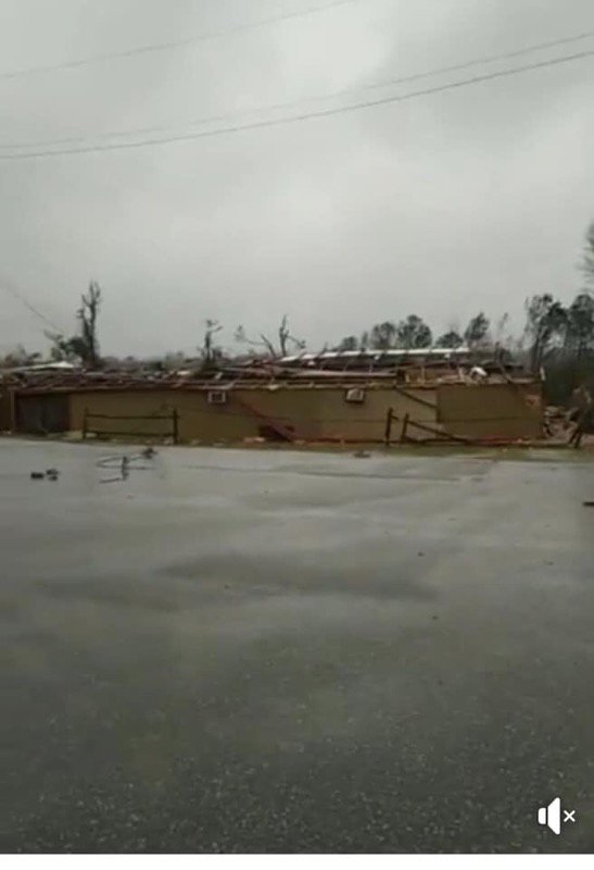
Posted on 3/3/19 at 2:59 pm to Roll Tide Ravens
Pic of the the first tornado that went through Smiths Station

Posted on 3/3/19 at 3:00 pm to Roll Tide Ravens
12 tornado warnings in AL and GA now.

Posted on 3/3/19 at 3:00 pm to NorthEndZone
Going straight for Talbotton
Posted on 3/3/19 at 3:01 pm to Bobby OG Johnson
quote:
Pic of the the first tornado that went through Smiths Station
Wow, that's incredible. Probably close to at least 1/2 mile wide.
Posted on 3/3/19 at 3:02 pm to Chatagnier
quote:
Going straight for Talbotton
Still has a well-defined debris signature.
Posted on 3/3/19 at 3:03 pm to Bobby OG Johnson
quote:
Pic of the the first tornado that went through Smiths Station
They are now included in this newest warning... crazy day for those folks.

Posted on 3/3/19 at 3:04 pm to Roll Tide Ravens
quote:
James Spann @spann
WRBL reports major damage at West Smiths Station Elementary School in Lee County (AL)
Posted on 3/3/19 at 3:05 pm to rds dc
I'm sure plenty of the OT types know of this place, BuckWild on HWY 280 in Bama.
Posted on 3/3/19 at 3:06 pm to rds dc
quote:
They are now included in this newest warning... crazy day for those folks.
Yep NWS was reporting only a 1.5 mile difference in between the 2 storms
Posted on 3/3/19 at 3:07 pm to rds dc
Damn, I drive by there everyday.
Posted on 3/3/19 at 3:07 pm to Roll Tide Ravens
East of Griffen Mill and moving at 65 mph!
Severe Weather Statement
National Weather Service Birmingham AL
300 PM CST SUN MAR 3 2019
ALC081-113-032130-
/O.CON.KBMX.TO.W.0025.000000T0000Z-190303T2130Z/
Lee AL-Russell AL-
300 PM CST SUN MAR 3 2019
...A TORNADO WARNING REMAINS IN EFFECT UNTIL 330 PM CST FOR
SOUTHEASTERN LEE AND NORTH CENTRAL RUSSELL COUNTIES...
At 300 PM CST, a confirmed large and extremely dangerous tornado was
located over Griffen Mill, or 7 miles west of Smiths, moving east at
65 mph.
This is a PARTICULARLY DANGEROUS SITUATION. TAKE COVER NOW!
HAZARD...Damaging tornado.
SOURCE...Radar confirmed tornado.
IMPACT...You are in a life-threatening situation. Flying debris may
be deadly to those caught without shelter. Mobile homes
will be destroyed. Considerable damage to homes,
businesses, and vehicles is likely and complete destruction
is possible.
Locations impacted include...
Smiths, Smiths Station, Bleecker, Griffen Mill, Ladonia, Monterey
Heights, Ladonia Sports Complex and Bartletts Ferry Dam.
PRECAUTIONARY/PREPAREDNESS ACTIONS...
To repeat, a large, extremely dangerous and potentially deadly
tornado is on the ground. To protect your life, TAKE COVER NOW! Move
to a basement or an interior room on the lowest floor of a sturdy
building. Avoid windows. If you are outdoors, in a mobile home, or in
a vehicle, move to the closest substantial shelter and protect
yourself from flying debris.
ETA - It should be near Smiths now.
This post was edited on 3/3/19 at 3:09 pm
Posted on 3/3/19 at 3:09 pm to Bobby OG Johnson
13 tornado warnings and The Weather Channel is telling us about snow and giving us really poor demonstrations of how to take shelter during a tornado warning.
Posted on 3/3/19 at 3:09 pm to NorthEndZone
Brandon Copic
@BrandonCopicWx
CELL TOWER BROUGHT Down by the Tornado in Smith Station

Posted on 3/3/19 at 3:11 pm to Bobby OG Johnson
Talbotton, GA took a direct hit. Debris signature blew up as it passed through there.
Posted on 3/3/19 at 3:13 pm to Roll Tide Ravens
WRBL reporting two fatalities in Beauregard, AL, south of Opelika.
Posted on 3/3/19 at 3:13 pm to Roll Tide Ravens
Another really big one south of the Talbotton one headed towards Ideal.

 Page 3 of 13

Popular
Back to top