- My Forums
- Tiger Rant
- LSU Recruiting
- SEC Rant
- Saints Talk
- Pelicans Talk
- More Sports Board
- Coaching Changes
- Fantasy Sports
- Golf Board
- Soccer Board
- O-T Lounge
- Tech Board
- Home/Garden Board
- Outdoor Board
- Health/Fitness Board
- Movie/TV Board
- Book Board
- Music Board
- Political Talk
- Money Talk
- Fark Board
- Gaming Board
- Travel Board
- Food/Drink Board
- Ticket Exchange
- TD Help Board
Customize My Forums- View All Forums
- Show Left Links
- Topic Sort Options
- Trending Topics
- Recent Topics
- Active Topics
Started By
Message
 3
3


Posted on 3/24/23 at 8:04 pm to Bobby OG Johnson
Continued
Spotter confirmed
Spotter confirmed
Posted on 3/24/23 at 8:04 pm to Bobby OG Johnson
That's a PDS warning.
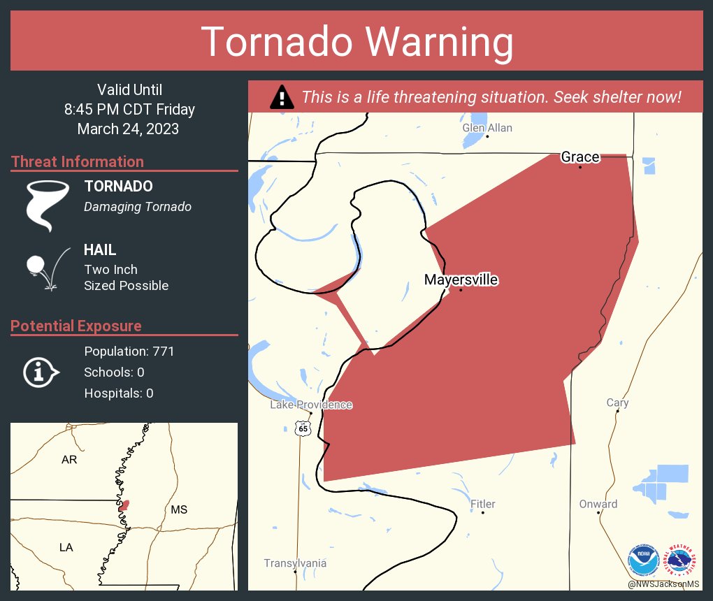
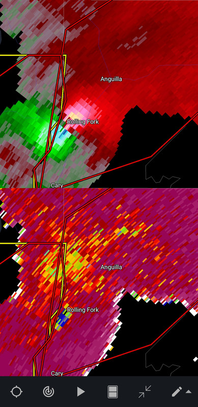
At 759 PM CDT, a large and extremely dangerous tornado was located 8 miles west of Rolling Fork, moving northeast at 40 mph.
This is a PARTICULARLY DANGEROUS SITUATION. TAKE COVER NOW!
HAZARD...Damaging tornado.
SOURCE...Radar indicated rotation.
IMPACT...You are in a life-threatening situation. Flying debris may be deadly to those caught without shelter. Mobile homes will be destroyed. Considerable damage to homes, businesses, and vehicles is likely and complete destruction is possible.
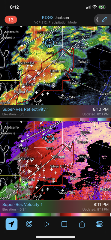
The tornado will be near... Rolling Fork around 810 PM CDT. Anguilla, Nitta Yuma and Panther Burn around 820 PM CDT. Delta City around 830 PM CDT. Midnight around 845 PM CDT. Belzoni around 900 PM CDT.
Other locations impacted by this tornadic thunderstorm include Silver City, Cary and Louise.
At 759 PM CDT, a large and extremely dangerous tornado was located 8 miles west of Rolling Fork, moving northeast at 40 mph.
This is a PARTICULARLY DANGEROUS SITUATION. TAKE COVER NOW!
HAZARD...Damaging tornado.
SOURCE...Radar indicated rotation.
IMPACT...You are in a life-threatening situation. Flying debris may be deadly to those caught without shelter. Mobile homes will be destroyed. Considerable damage to homes, businesses, and vehicles is likely and complete destruction is possible.
The tornado will be near... Rolling Fork around 810 PM CDT. Anguilla, Nitta Yuma and Panther Burn around 820 PM CDT. Delta City around 830 PM CDT. Midnight around 845 PM CDT. Belzoni around 900 PM CDT.
Other locations impacted by this tornadic thunderstorm include Silver City, Cary and Louise.
Posted on 3/24/23 at 8:05 pm to Bobby OG Johnson

Posted on 3/24/23 at 8:06 pm to Bobby OG Johnson
Emergency
Take cover
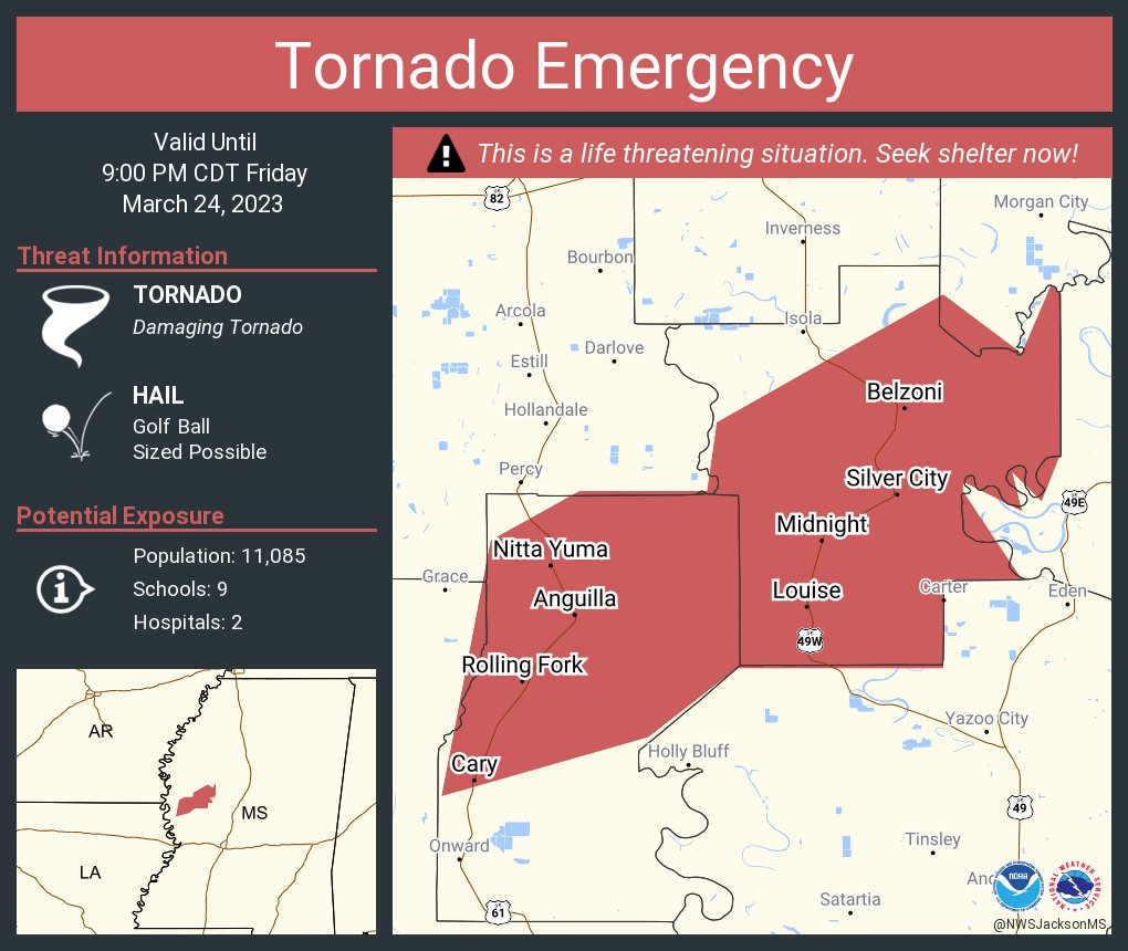
Take cover
Posted on 3/24/23 at 8:06 pm to tiger91
quote:
Delta oxford should be fine?
Nevermind. That is the northern warning, not the confirmed one. My bad.
This post was edited on 3/24/23 at 8:10 pm
Posted on 3/24/23 at 8:07 pm to Bobby OG Johnson
quote:
Ben McHone
@Tornado_Warned
·
5m
Big tornado on the ground, west of Rolling Fork, MS

Posted on 3/24/23 at 8:07 pm to NorthEndZone
Saying it’s a mile wide tornado. Going to level Rolling Fork and head to Belzoni. About 15 miles south of me, storm was tracking to me but it turned more right thankfully
Posted on 3/24/23 at 8:09 pm to tiger91
Oxford may find itself in a tornado warning here in a few minutes
This post was edited on 3/24/23 at 8:11 pm
Posted on 3/24/23 at 8:09 pm to Bobby OG Johnson

Posted on 3/24/23 at 8:10 pm to Bobby OG Johnson
Damn that does look big for that area
Usually don't see pics like that
Usually don't see pics like that
Posted on 3/24/23 at 8:10 pm to Bobby OG Johnson
Emergency continued

Posted on 3/24/23 at 8:11 pm to Bobby OG Johnson
Another Nola bust

Posted on 3/24/23 at 8:11 pm to t00f
Raining and lightning like a sumbitch in East Mempho.
Posted on 3/24/23 at 8:11 pm to Bobby OG Johnson
quote:
Zachary Hall
@WxZachary
·
5m
Big tornado just south of Rolling Fork, Mississippi. Could hear the roar. INSANE. #mswx @NWSJacksonMS
@wx_Frankie put us in perfect position.

Posted on 3/24/23 at 8:12 pm to Bobby OG Johnson
dear lord that is massive and sad - hope for the best for rolling fork. glad your ok Delta
Posted on 3/24/23 at 8:12 pm to Bobby OG Johnson
I don't like the way things are looking as far as the atmosphere when this thing enters the Tennsippibama area
Still awful warm and seems more unstable, hopefully we get caught in the line and not out in the open....
Still awful warm and seems more unstable, hopefully we get caught in the line and not out in the open....
Posted on 3/24/23 at 8:12 pm to Bobby OG Johnson
A little too close for comfort
Posted on 3/24/23 at 8:13 pm to Bobby OG Johnson
From Spann


 Page 7 of 32

Popular
Back to top