- My Forums
- Tiger Rant
- LSU Recruiting
- SEC Rant
- Saints Talk
- Pelicans Talk
- More Sports Board
- Fantasy Sports
- Golf Board
- Soccer Board
- O-T Lounge
- Tech Board
- Home/Garden Board
- Outdoor Board
- Health/Fitness Board
- Movie/TV Board
- Book Board
- Music Board
- Political Talk
- Money Talk
- Fark Board
- Gaming Board
- Travel Board
- Food/Drink Board
- Ticket Exchange
- TD Help Board
Customize My Forums- View All Forums
- Show Left Links
- Topic Sort Options
- Trending Topics
- Recent Topics
- Active Topics
Started By
Message
re: Multi-day Severe Weather Threat: 3/23-3/24
Posted on 3/26/23 at 9:19 pm to LegendInMyMind

Posted on 3/26/23 at 9:19 pm to LegendInMyMind
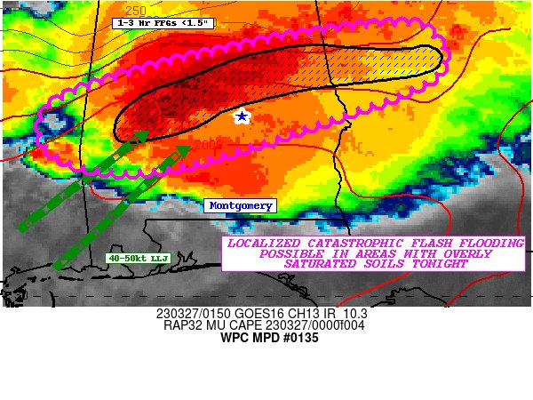
WPC talking about the potential for catastrophic flooding across a corridor from east-central Mississippi across central Alabama and into Georgia.
 1
1

Posted on 3/26/23 at 9:21 pm to Roll Tide Ravens
Radar estimates, which are pretty accurate, have a swath of 6"+ across central AL. The FF Warning calls for an additional 1-3" across the area. There will be some problems.
Posted on 3/26/23 at 9:27 pm to LegendInMyMind
quote:
Where are you? Keep an eye on the comma head forming West of Selma. That's a rear inflow jet that is trying to wrap up a bookend vortex.
I'm at work in Alex City.
I'm keepin my eye on the radar for sure. Luckily the temp just dropped real fast again down to 65.
We have had some unreal amounts of rain since yesterday.
Posted on 3/26/23 at 9:31 pm to auggie
quote:
We have had some unreal amounts of rain since yesterday.
Yep. See the graphic RTR just posted. Talks of catastrophic flooding and you're area is in it. Don't know what time you clock out, but that could be a tough drive home.
This post was edited on 3/26/23 at 9:31 pm

Posted on 3/26/23 at 9:32 pm to Roll Tide Ravens
quote:
There used to be one there back in the day but it was decommissioned in the late 90’s and never replaced. We need one there and then another back near Greenville, MS.
This. Meridian NAS and the old Greenville AFB would be a good start.

Posted on 3/26/23 at 9:33 pm to Roll Tide Ravens
quote:
and then another back near Greenville, MS.
Just need to get KULM fixed

Posted on 3/26/23 at 9:33 pm to ssand
My preferred location for a new radar has been a little bit more east, around Linden, south of Demopolis. Anywhere down there would help.
Posted on 3/26/23 at 9:34 pm to The Boat
quote:
Just need to get KULM fixed
I thought we put you on that job.
Posted on 3/26/23 at 9:37 pm to LegendInMyMind
quote:
Yep. See the graphic RTR just posted. Talks of catastrophic flooding and you're area is in it. Don't know what time you clock out, but that could be a tough drive home.
I'll be here until about 7:30 am. I've got a 25 mile drive home, across several big creeks too.
Posted on 3/26/23 at 9:40 pm to LegendInMyMind
Need an east Texas radar too. Somewhere around Crockett
Posted on 3/26/23 at 9:48 pm to The Boat
Between Millbrook and Deatsville looks like a bookend vortex trying to form.
Posted on 3/26/23 at 10:04 pm to LegendInMyMind
Definitely getting that comma head look north of Montgomery.
Posted on 3/26/23 at 10:10 pm to Roll Tide Ravens
quote:
Definitely getting that comma head look north of Montgomery.
That's around the Equality/Eclectic area. Exactly where a small tornado went through a few weeks ago.
Posted on 3/26/23 at 10:21 pm to Roll Tide Ravens
NWS Birmingham is starting to ramp the threat down.

Posted on 3/26/23 at 10:25 pm to Roll Tide Ravens
quote:
NWS Birmingham is starting to ramp the threat down.
That makes sense. It's really cooled way down.
Just a lot of rain and lightning now. There really hasn't even been much wind.
Posted on 3/26/23 at 10:29 pm to auggie
That area I mentioned finally wrapped up and is warned now. South of Dadeville. Shouldn't last long as it has lost its rear inflow notch.
This post was edited on 3/26/23 at 10:31 pm

Posted on 3/26/23 at 10:32 pm to auggie
They did a pretty good job of calling for bad weather today and tonight in that fairly narrow area across Alabama and into Georgia.
We're just north of that and all the bad weather has tracked just south of us in the watch areas
We're just north of that and all the bad weather has tracked just south of us in the watch areas
Posted on 3/26/23 at 10:36 pm to East Coast Band
quote:
They did a pretty good job of calling for bad weather today and tonight in that fairly narrow area across Alabama and into Georgia.
We're just north of that and all the bad weather has tracked just south of us in the watch areas
Yep, That's how it should be done.
Posted on 3/26/23 at 10:37 pm to LegendInMyMind
Could use that KMXX radar right about now.
ETA: tornado warning canceled.
ETA: tornado warning canceled.
This post was edited on 3/26/23 at 10:39 pm
Posted on 3/26/23 at 10:37 pm to Roll Tide Ravens
I'm guessing it is being refurbished?

 Page 31 of 32

Popular
Back to top