- My Forums
- Tiger Rant
- LSU Recruiting
- SEC Rant
- Saints Talk
- Pelicans Talk
- More Sports Board
- Fantasy Sports
- Golf Board
- Soccer Board
- O-T Lounge
- Tech Board
- Home/Garden Board
- Outdoor Board
- Health/Fitness Board
- Movie/TV Board
- Book Board
- Music Board
- Political Talk
- Money Talk
- Fark Board
- Gaming Board
- Travel Board
- Food/Drink Board
- Ticket Exchange
- TD Help Board
Customize My Forums- View All Forums
- Show Left Links
- Topic Sort Options
- Trending Topics
- Recent Topics
- Active Topics
Started By
Message
re: Morganza Spillway may or may not open for a 3rd time -- lack of clear info from ACoE
Posted on 5/24/19 at 9:13 am to WizardSleeve

Posted on 5/24/19 at 9:13 am to WizardSleeve
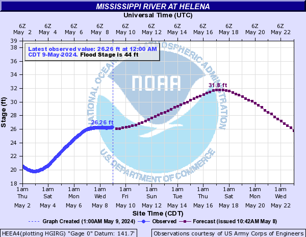
Crest has been inched higher this morning to 44.5'. It was previously at 44.4' yesterday. Not that it's surprising - most can take a look at weather models up north and see all the rain that's likely going to fall up there and discern that the river rise will be higher than currently forecast. Hell, it's already at 44.08' this morning. If 5"-10" of rain fall over as large a geographical area as models are pointing at I could see the crest in BR upwards of 45'-46'.
*I'm not an expert - I'm just giving my observation and opinion*
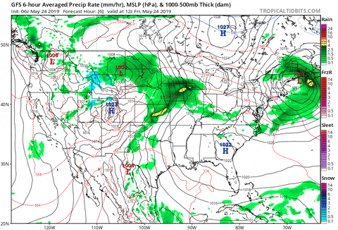
Then there's this run of the FGFS (which is less reliable but still worth noting)


That is an ENORMOUS area of 4"-5" rainfall that will be draining into the Mississippi and making its way here by the end of the first week of June. This event may not break records but it has the potential to get close.
*I'm not an expert - I'm just giving my observation and opinion*
Then there's this run of the FGFS (which is less reliable but still worth noting)
That is an ENORMOUS area of 4"-5" rainfall that will be draining into the Mississippi and making its way here by the end of the first week of June. This event may not break records but it has the potential to get close.
This post was edited on 5/24/19 at 9:26 am
 1
1

Posted on 5/24/19 at 9:28 am to WizardSleeve
I saw today in The Advocate that there is a West Atchafalaya Floodway. It has never been used. I have never heard of it.
Could one of you amateur hydrologist explain why it has never been used? And what circumstances would have to exist to use it?
Could one of you amateur hydrologist explain why it has never been used? And what circumstances would have to exist to use it?

Posted on 5/24/19 at 9:30 am to FelicianaTigerfan
quote:
Rumor is that pipelines, roads, and bridges couldnt handle it
It ain't a rumor
^^^^ This study discussed what would happen to I-10 when it was barely 10 years old.
Posted on 5/24/19 at 9:53 am to Cosmo
quote:
Possibly the trashiest casino on the planet
The Belle is a GD national treasure.

Posted on 5/24/19 at 10:44 am to doublecutter
Only thing i could find:
quote:
The Floodway was designed to be activated at 19,300 m3/s by passive overtopping of the 12-km-long fuseplug section along its northern end, built at a lower elevation than the rest of the levee (Figure 3) [7,25]. In addition to receiving 7,000 m3/s from overtopping of the fuseplug, the West Atchafalaya Floodway was designed to receive inflow from Bayou Current from the west before discharging at its downstream end into the Atchafalaya Basin Floodway. The purpose of the West Atchafalaya Floodway is to lower stages in the Atchafalaya and Red Rivers, and in the Mississippi River itself by virtue of accommodating some of the water drawn off the mainstem at the Old River Control Structure. Under the MR & T plan, this floodway would be the last component of the MR & T system to be activated , and in fact, it has never been used.
Posted on 5/24/19 at 11:17 am to slackster
quote:
One good measure for the water height on this side of the basin is Bayou Boeuf in Amelia. It has been rising almost since the start of the year. I could tell by the increasing steepness of the ramp to get to the casino in Amelia. , not sure if this was meant to be funny, but I laughed.
It wasn’t but I guess reading it back there is some comedic value in that statement.

Posted on 5/24/19 at 11:41 am to AlxTgr
quote:
Only thing i could find:
I also found this on the wikipedia page...

This post was edited on 5/24/19 at 11:42 am
Posted on 5/24/19 at 11:49 am to MountainTiger
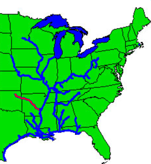
Anyone know how all this water from the Arkansas River is going to effect levels? Just watched a video from a Corp guy saying they're predicting flows around 425kcfs just north of Little Rock
Posted on 5/24/19 at 12:13 pm to PipelineBaw
If they get significant rain amounts in areas that flow into it outside of 48hrs then id say itll get higher than they are telling
Posted on 5/24/19 at 12:14 pm to PipelineBaw
quote:
Anyone know how all this water from the Arkansas River is going to effect levels?
That is cooked into the projections. The hard to account for is future rain.
Posted on 5/24/19 at 12:19 pm to TDsngumbo
quote:
Crest has been inched higher this morning to 44.5'. It was previously at 44.4' yesterday. Not that it's surprising - most can take a look at weather models up north and see all the rain that's likely going to fall up there and discern that the river rise will be higher than currently forecast. Hell, it's already at 44.08' this morning. If 5"-10" of rain fall over as large a geographical area as models are pointing at I could see the crest in BR upwards of 45'-46'.
I wouldn't worry a ton about the rainfall in the plains unless it gets really out of hand across a large area. The river is already 3 feet lower in northern Mississippi than the crest, so it's got room for more rain.
The issue for LA would be rain in and very near LA, not in the Ohio and Mississippi River Valleys.
Posted on 5/24/19 at 12:23 pm to doublecutter
quote:
I saw today in The Advocate that there is a West Atchafalaya Floodway. It has never been used. I have never heard of it. Could one of you amateur hydrologist explain why it has never been used? And what circumstances would have to exist to use it?
It's similar to the New Madrid floodway. It takes the pressure off the water backing up where the ORCS and Red River meet, but it ultimately sends it down the Atchafalaya still.
New Madrid takes pressure off the Ohio River and Mississippi River junction, but the water still flows into the Mississippi River. It just makes the choke point bigger.
Posted on 5/24/19 at 12:29 pm to slackster
quote:
The issue for LA would be rain in and very near LA, not in the Ohio and Mississippi River Valleys.
It's the Arkansas River that's the problem currently. A rise upriver won't help if it keeps getting dumped on.
It's true though rain falling north of the Arkansas drainage basin isn't likely to make the coming crest worse. More just keep the river levels high longer into the summer. As long as we're dropping to reasonable levels by August, not a huge concern.
Posted on 5/24/19 at 12:35 pm to Duke
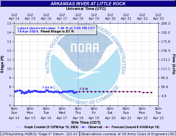
The Arkansas at Little Rock is predicted to damn near double. That's insane.
Posted on 5/24/19 at 12:36 pm to MountainTiger
Looking at the diagram of the Atchafalaya, it shows a Red River at 300k cfs. If it's higher, how much more of a problem that could add to the situation.
Also, I believe since we were in a dry spell in 2011, the Red was no where near 300k cfs so that too added a little more relief to the situation and it probably flowed backwards where the Red meets ORCS. But if you have the Red River at 300k cfs, then that doesn’t give you much more space for additional water..
Also, I believe since we were in a dry spell in 2011, the Red was no where near 300k cfs so that too added a little more relief to the situation and it probably flowed backwards where the Red meets ORCS. But if you have the Red River at 300k cfs, then that doesn’t give you much more space for additional water..

Posted on 5/24/19 at 12:39 pm to udtiger
So is the Old River Control Structure going to fail and is the River about to change course or what fellas?
Posted on 5/24/19 at 12:40 pm to Duke
That's a highly populated area wouldn't you say?

Posted on 5/24/19 at 12:43 pm to GeorgeTheGreek
quote:
The Arkansas at Little Rock is predicted to damn near double. That's insane.
Been a parade of storms over the Arkansas drainage area, and that pattern doesn't look to be changing in the next week. It does, at least, look like more of the future rain will fall on the Missouri and middle Mississippi vs the Arkansas.
quote:
So is the Old River Control Structure going to fail and is the River about to change course or what fellas?
What's your timeframe on that question?
Posted on 5/24/19 at 12:43 pm to WizardSleeve
quote:
The river will silt up just downstream of the breach and cease to flow....
Question...what about cutting a channel back from the Atchafalaya to the MS river to get water flowing again? Hell, if Captain Shreve could dig the Shreve Cut in 1831, we should be able to do it (hopefully in less than 8 years).
From Wikipedia....
In the heyday of steamboats along the Mississippi River, it would take a boat several hours to travel the 20 miles (32 km) of Turnbull's Bend, after which it would have progressed only about 1 mile (1.6 km) from the entrance to the bend. To reduce travel time, Captain Henry M. Shreve, a river engineer and namesake of Shreveport, Louisiana, dug a canal in 1831 through the neck of Turnbull's Bend; this canal became known as Shreve's Cut. At the next high water, the Mississippi roared through this channel. The upper portion of Turnbull's Bend became the smaller Upper Old River while the lower portion became the larger Lower Old River. At first, the Lower Old River would flow eastward, to the Mississippi, until 1839, when locals began removing a log jam that was obstructing the Atchafalaya River. The project was finished in 1840.
Wiki Link
Posted on 5/24/19 at 12:48 pm to tgrbaitn08
quote:
That's a highly populated area wouldn't you say?
Highly populated for the plains at least, and the most populated areas (Wichita ---> downriver) are the ones dealing with the flooding unfortunately.

 Page 65 of 107

Back to top