- My Forums
- Tiger Rant
- LSU Recruiting
- SEC Rant
- Saints Talk
- Pelicans Talk
- More Sports Board
- Fantasy Sports
- Golf Board
- Soccer Board
- O-T Lounge
- Tech Board
- Home/Garden Board
- Outdoor Board
- Health/Fitness Board
- Movie/TV Board
- Book Board
- Music Board
- Political Talk
- Money Talk
- Fark Board
- Gaming Board
- Travel Board
- Food/Drink Board
- Ticket Exchange
- TD Help Board
Customize My Forums- View All Forums
- Show Left Links
- Topic Sort Options
- Trending Topics
- Recent Topics
- Active Topics
Started By
Message
re: Morganza Spillway may or may not open for a 3rd time -- lack of clear info from ACoE
Posted on 3/4/19 at 7:10 pm to rt3
Posted on 3/4/19 at 7:10 pm to rt3
In the book “rising tide” this is the close to the same weather pattern they had in 1927
Wet fall all the way from gulf up to Minnesota
Wet spring in same areas with plenty of snowfall
Hopefully when the snow starts to melt the Tennessee and Ohio Valleys will go through a dry period
Wet fall all the way from gulf up to Minnesota
Wet spring in same areas with plenty of snowfall
Hopefully when the snow starts to melt the Tennessee and Ohio Valleys will go through a dry period
 0
0

Posted on 3/5/19 at 3:46 pm to TDsngumbo
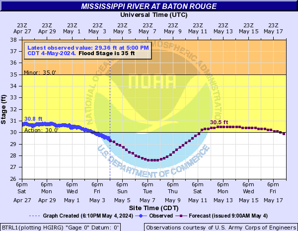
Looks like crest in BR got bumped up 44’.
Posted on 3/5/19 at 3:56 pm to Capt ST
Hypothetically if the levee broke without warning in BR, would it be the worst natural disaster in US history? You'd have 300,000 people sitting on their roofs.
Posted on 3/5/19 at 4:11 pm to Jim Rockford
I mean yeah, a surprise 10' flood would be bad for Baton Rouge.
Posted on 3/5/19 at 4:16 pm to Jim Rockford
There’s a lot of us in BR that wouldn’t flood.
Posted on 3/5/19 at 4:21 pm to Jim Rockford
quote:
Hypothetically if the levee broke without warning in BR, would it be the worst natural disaster in US history? You'd have 300,000 people sitting on their roofs.
300,000 people? It would no doubt be a disaster but you are overestimating the inundation.
Posted on 3/5/19 at 4:30 pm to FelicianaTigerfan
quote:
They would open Morganza and blow levees up north flooding 100ks of acres of farm land before BR / NO levees get topped. If that ain’t enough then ORCS is, as many believe, vulnerable.
Are you referring to Bird Point floodway protecting Cairo?
Posted on 3/5/19 at 4:33 pm to NYNolaguy1
quote:
Are you referring to Bird Point floodway protecting Cairo?
Thing about that is the water would run back into the river downstream. It would take the pressure off Cairo (which is a ghost town now, btw. there's nothing to protect any more). But it wouldn't affect the downstream water levels.

Posted on 3/5/19 at 5:09 pm to FeauxPaw
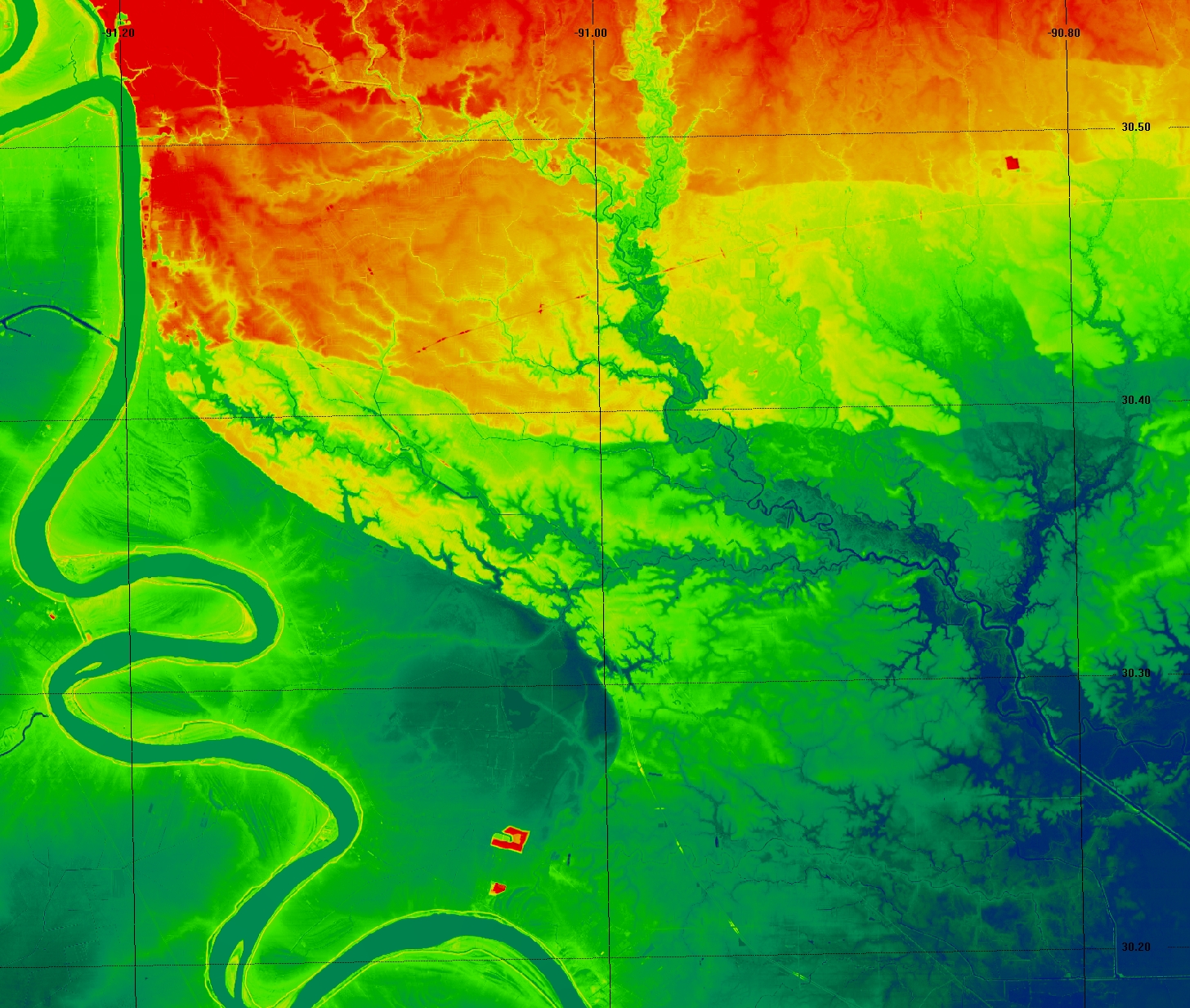
quote:
That's kinda impressive. Know what those two red spots are in the Southern part of this scan?
They're the gypstacks in between Geismar and St. Gabriel. The big red blotch is the big one at 30 and 3115.
This post was edited on 3/5/19 at 5:11 pm
Posted on 3/5/19 at 5:37 pm to TigerstuckinMS
I live in St Gabriel
I’m fuuuuuuuuuucked
I’m fuuuuuuuuuucked
Posted on 3/5/19 at 6:01 pm to Capt ST
And it looks like they bumped up crest date a few days
Posted on 3/5/19 at 6:09 pm to LSUsmartass
What is crest date as of now?
Posted on 3/5/19 at 6:30 pm to MonroeTigerstripes
12th

Posted on 3/5/19 at 6:31 pm to LSUsmartass
What’s that rainbow river picture I’m looking at?
Posted on 3/5/19 at 7:12 pm to FeauxPaw
Very cool and helpful map. Can you post the next block over over, E. of -90.80?
What would the impact be there on watersheds below 1-12? Especially Tangipahoa and Tchefuncte Rvers?
What would the impact be there on watersheds below 1-12? Especially Tangipahoa and Tchefuncte Rvers?

Posted on 3/5/19 at 7:30 pm to GeorgeTheGreek
That’s topography of BR area

Posted on 3/5/19 at 7:31 pm to Jim Rockford
It would be pretty bad. My guess is that it would get pretty close to Highland Rd
Posted on 3/5/19 at 10:39 pm to BlindTiger7
It went to 45' back in 2011. That was the highest it's been since 1945.
47' was the great flood of 1927, but obviously that was before the new infrastructure was put in place.
47' was the great flood of 1927, but obviously that was before the new infrastructure was put in place.
This post was edited on 3/5/19 at 10:41 pm

Posted on 3/6/19 at 8:30 am to TDsngumbo
Bump for the latest forecast bumping it up to 44'.
Posted on 3/6/19 at 8:57 am to TDsngumbo
GFS shows about 50/50 below freezing temps and well above freezing temps for the central/northern plains as well as the Ohio River valley over the next two weeks. Combined with more rain, the snow will start to melt then refreeze then melt again.

 Page 30 of 107

Popular
Back to top