- My Forums
- Tiger Rant
- LSU Recruiting
- SEC Rant
- Saints Talk
- Pelicans Talk
- More Sports Board
- Coaching Changes
- Fantasy Sports
- Golf Board
- Soccer Board
- O-T Lounge
- Tech Board
- Home/Garden Board
- Outdoor Board
- Health/Fitness Board
- Movie/TV Board
- Book Board
- Music Board
- Political Talk
- Money Talk
- Fark Board
- Gaming Board
- Travel Board
- Food/Drink Board
- Ticket Exchange
- TD Help Board
Customize My Forums- View All Forums
- Show Left Links
- Topic Sort Options
- Trending Topics
- Recent Topics
- Active Topics
Started By
Message
re: Major Severe Weather Outbreak: March 14-16, 2025
Posted on 3/16/25 at 11:28 pm to TheRouxGuru
Posted on 3/16/25 at 11:28 pm to TheRouxGuru
quote:
Where is the best place to find the ‘tracks’ of these tornados? Specifically the ones in tylertown
When they get updated they will be added to this site with a fairly exact path and damage examples. NWS Jackson hasn't added any yet, but they should in a day or two.
Storm Damage Viewer
They'll also release updates via Xwitter @NWSJacksonMS
 0
0

Posted on 3/16/25 at 11:29 pm to SidewalkTiger
quote:
A LOT of EF-3's in this outbreak
Loading Twitter/X Embed...
If tweet fails to load, click here.Posted on 3/17/25 at 3:41 am to tarzana
Pretty sure the Jarrell tornado became a wedge at one point
This post was edited on 3/17/25 at 3:44 am

Posted on 3/17/25 at 10:54 am to Roll Tide Ravens

Posted on 3/17/25 at 11:06 am to Roll Tide Ravens
Spann is currently publicly shaming some guy on Twitter for a post
Posted on 3/17/25 at 11:14 am to Bobby OG Johnson
quote:
Spann is currently publicly shaming some guy on Twitter for a post
He had a hair trigger on that one. That guy wasn't bashing, or even complaining, he just worded it poorly. He deleted the original post and explained it in the replies to James.
Posted on 3/17/25 at 11:24 am to LegendInMyMind
Yeah I think Spann should take a breather from doing that to folks
Posted on 3/17/25 at 12:04 pm to Bobby OG Johnson
I think Spann feels a level of personal responsibility when there is loss of life in the area he covers. Obviously none of those deaths were his fault, but because he is so well-known he looks at people dying in tornadoes as a failure on his part. When someone acts like an event was nothing when there was indeed significant damage and loss of life, it really gets under Spann’s skin.
Posted on 3/17/25 at 12:35 pm to Roll Tide Ravens
agreed RTR - Spann for the most part lets that stuff slide, but he is human and just gets the point of it boiling over - we all do.
that said, I can agree with chilling on it - IF he did not come back to the guy, after he clarified, and accepted and walked it back as well.
that said, I can agree with chilling on it - IF he did not come back to the guy, after he clarified, and accepted and walked it back as well.
Posted on 3/17/25 at 1:53 pm to Bobby OG Johnson
In a Jordan Hall drone video of the damage from the Diaz, Arkansas EF4 you can see the home with the safe room.
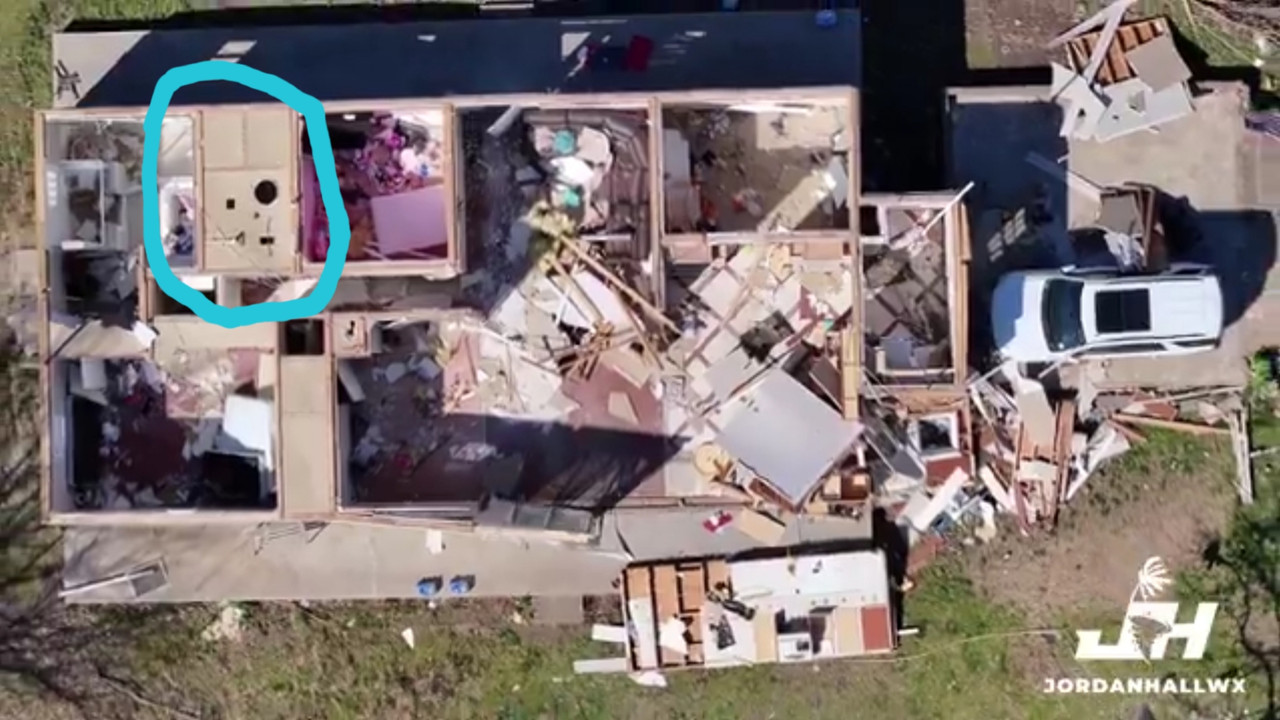
It looks like the hallway at the back of the house partially remains.
It looks like the hallway at the back of the house partially remains.
This post was edited on 3/17/25 at 1:54 pm
Posted on 3/17/25 at 2:54 pm to SidewalkTiger
I didn't realize in my video I caught power flash, so I think I can say I finally saw my first tornado. It just wasn't the pretty textbook photo

Posted on 3/17/25 at 2:56 pm to schwartzy
those rain wrapped ones are tricky man - good photo, glad you are safe as well.
Posted on 3/17/25 at 4:54 pm to Roll Tide Ravens
Posted on 3/17/25 at 4:56 pm to Roll Tide Ravens
Amazing how they seem to form in the same spot one after another often
Posted on 3/17/25 at 5:18 pm to Roll Tide Ravens
12 states with confirmed tornadoes, and there could possibly be one or two added from yesterday.
Posted on 3/17/25 at 5:48 pm to LegendInMyMind
total nothing burger.....wait....shite my sarcasm button is stuck on.....sorry
Posted on 3/17/25 at 5:50 pm to Thracken13
Well baws, after a look around, I had to file insurance claims on my house and truck.
Both had quite a bit of hail damage.
Both had quite a bit of hail damage.
Posted on 3/17/25 at 5:54 pm to SidewalkTiger
Steve Caparotta WAFB
TYLERTOWN TORNADO NOW RATED EF-4
NEW: US National Weather Service New Orleans Louisiana has determined that the tornado that initially touched down near Kentwood reached EF-4 intensity in Tylertown, MS with maximum winds estimated around 170 mph.


TYLERTOWN TORNADO NOW RATED EF-4
NEW: US National Weather Service New Orleans Louisiana has determined that the tornado that initially touched down near Kentwood reached EF-4 intensity in Tylertown, MS with maximum winds estimated around 170 mph.
Posted on 3/17/25 at 6:14 pm to lsuman25
That is a low latitude for such a powerful tornado. Usually those big long track EF-3+ monsters are closer to I-20 or I-40.
Posted on 3/17/25 at 6:34 pm to lsuman25
quote:
TYLERTOWN TORNADO NOW RATED EF-4
NEW: US National Weather Service New Orleans Louisiana has determined that the tornado that initially touched down near Kentwood reached EF-4 intensity in Tylertown, MS with maximum winds estimated around 170 mph.
That is about 9 miles from potentially being the strongest tornado in Louisiana state history.
The tornadoes of April 24, 1908 may be comparable, but there are only retroactive surveys for those.
This post was edited on 3/17/25 at 6:40 pm

 Page 86 of 88

Popular
Back to top