- My Forums
- Tiger Rant
- LSU Recruiting
- SEC Rant
- Saints Talk
- Pelicans Talk
- More Sports Board
- Coaching Changes
- Fantasy Sports
- Golf Board
- Soccer Board
- O-T Lounge
- Tech Board
- Home/Garden Board
- Outdoor Board
- Health/Fitness Board
- Movie/TV Board
- Book Board
- Music Board
- Political Talk
- Money Talk
- Fark Board
- Gaming Board
- Travel Board
- Food/Drink Board
- Ticket Exchange
- TD Help Board
Customize My Forums- View All Forums
- Show Left Links
- Topic Sort Options
- Trending Topics
- Recent Topics
- Active Topics
Started By
Message
re: Let's Do It Again: Severe Threat 3/30 - Line of Severe Storms leaving SELA. AL in it now
Posted on 3/31/22 at 9:01 am to Duke
Posted on 3/31/22 at 9:01 am to Duke
2 fatalities in the FL panhandle near Alford, FL in a very rural area. Nighttime tornado in an area that doesn't get a lot of them. Terrible for those impacted.
quote:
PRELIMINARY LOCAL STORM REPORT
NATIONAL WEATHER SERVICE TALLAHASSEE FL
832 AM EDT THU MAR 31 2022
..TIME... ...EVENT... ...CITY LOCATION... ...LAT.LON...
..DATE... ....MAG.... ..COUNTY LOCATION..ST.. ...SOURCE....
..REMARKS..
0514 AM TORNADO 3 WSW ALFORD 30.68N 85.44W
03/31/2022 WASHINGTON FL EMERGENCY MNGR
*** 2 FATAL, 3 INJ ***
2 HOMES DESTROYED, ONE ON GILBERTS MILL ROAD
AND THE OTHER ON JEWELL ROAD. 2 FATALTIES
AND 3 INJURIES REPORTED BY EMERGENCY
MANAGEMENT.
 0
0

Posted on 3/31/22 at 9:02 am to Roll Tide Ravens

Winds delivered in Mississippi, and the breakdown just led to tornadoes in Alabama.
Good forecast on this one.

Posted on 3/31/22 at 9:03 am to Duke
Wow, right over the moderate risk zone.

Posted on 3/31/22 at 9:32 am to Duke
Those symbols on that map look like a particular county shape.

Posted on 3/31/22 at 9:36 am to Duke
quote:
Looking like yes.
so why do these systems seem like they get a weekly pattern this time of year? is it just because that is the timeframe for the systems to come together and the other to move on?
I have a very vivid memory of getting hit with these systems every weekend during 2020, mostly because I was at home and had my computer set up on my dining room table and would stay up all night watching storm chasers, but also being mad that it was every weekend

Posted on 3/31/22 at 10:00 am to Duke
I wonder why the EF3 tornado in northwest Arkansas isn’t on the map.
It caused a lot of damage and injuries.
It caused a lot of damage and injuries.
Posted on 3/31/22 at 10:09 am to Cosmo
quote:
EBR schools already announced they are closed next tuesday
Hopefully next tuesday is just a good soaking. I’ve had enough severe and just want a good rain dammit it’s been so dry
Posted on 3/31/22 at 10:17 am to Salmon
quote:
so why do these systems seem like they get a weekly pattern this time of year? is it just because that is the timeframe for the systems to come together and the other to move on?
Interesting question.
Big picture, you can think of the atmosphere as a set of waves going around the world. You get peaks (ridges) and troughs and there's a period between them.
The periods differ and the number of waves differ depending on details (that I dont understand well enough to explain in plain english). Right now, its about 7 days between them.
Then when its March/April, you have many of the ingredients for severe already in place. Warming Gulf and cold air still in the west and southern Canada. Plus the snowpack in the Rockies leads to cooling the mid-levels as it passes over, leading to colder air aloft and warmer gulf air under it.
So you just need an upper low (trough in our big picture oversimplifed wave) to induce low pressure formation at the surface and you get severe weather threats.
In summer, this all still happens just much further north. In winter you see it as cold snaps, rain, and the occasional severe threat near the coast.
Posted on 3/31/22 at 10:27 am to Cosmo
quote:
EBR schools already announced they are closed next tuesday
I see your sarcasm.
I'll say this much, the next round does not look as potent as the last two did.
Posted on 3/31/22 at 10:30 am to gumbeaux
quote:
I wonder why the EF3 tornado in northwest Arkansas isn’t on the map.
It caused a lot of damage and injuries.
I imagine it's a 24-hour map... my guess being 7 AM Wednesday to 7 AM Thursday or something like that
Posted on 3/31/22 at 10:46 am to rt3
Yeah. It was on the previous period's map.

Posted on 3/31/22 at 11:15 am to gumbeaux
quote:
I wonder why the EF3 tornado in northwest Arkansas isn’t on the map.
It caused a lot of damage and injuries.
It should be on the day before.
ETA: My bad. Replied before finishing the thread.
This post was edited on 3/31/22 at 11:17 am
Posted on 3/31/22 at 11:18 am to Duke
@NWSBirmingham
quote:
We will be sending out 3 teams today to conduct storm surveys across multiple counties in Central Alabama. Due to the numerous areas in need of investigation, surveys may be ongoing for the next few days. We will share our findings with you as they we get them. #alwx
Posted on 3/31/22 at 11:21 am to LegendInMyMind
@NWSJackson
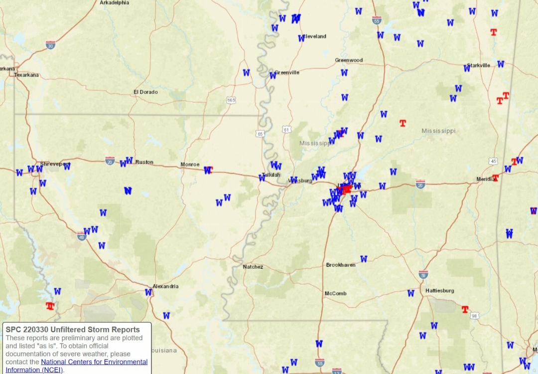
quote:
Yesterday's storms brought widespread reports of wind damage and at least several tornadoes. Here's a preliminary look at storm reports sent in already. If you know of damage, please send us a report, picture, and time of damage. Thanks! #lawx #mswx #arwx LINK
Posted on 3/31/22 at 11:23 am to LegendInMyMind
@NWSNewOrleans
quote:
NWS Meteorologists will be surveying storm damage today.
In Louisiana, near Rosedale and Lacombe.
In Mississippi, near Vancleave. As surveys are completed, we will send out info in the coming days.
LINK

Posted on 3/31/22 at 11:25 am to LegendInMyMind
Either weather reads the OT and hates Jackson OR there's alot of insurance fraud going on over there
Posted on 3/31/22 at 11:45 am to Duke
High CAPE environment on the 5th?

This post was edited on 3/31/22 at 11:46 am
Posted on 3/31/22 at 11:47 am to PureBlood
Looking through the observation sites for AL and MS, it looks like the gradient winds maximized over an area from Bham up to the Morgan/Limestone county area. Birmingham saw the highest gust at 58mph. The Decatur observation site, which is in Limestone County (even though Decatur is in Morgan County) saw a 5 minute sustained of 40mph with a max gust of 55mph. That site experienced a problem and stopped reporting around 9PM-ish, but I don't think it missed higher winds.
These were all winds that were ahead of the line. The line really didn't give us any trouble. Heavy rain for a bit with an uptick in winds as one section hit a pocket of higher instability.
We have a few limbs down and a neighbor had the top taken out of a tree that was already damaged.
These were all winds that were ahead of the line. The line really didn't give us any trouble. Heavy rain for a bit with an uptick in winds as one section hit a pocket of higher instability.
We have a few limbs down and a neighbor had the top taken out of a tree that was already damaged.
Posted on 3/31/22 at 11:57 am to DVinBR
quote:
High CAPE environment on the 5th?
Looks like April CAPE.
This next setup isn't looking nearly as potent as the last two. The trough ejection doesn't look very good, the lower level jet is oddly placed, away from where storms will develop. That CAPE maximizes early before storms get going. That said, that is the GFS and five days out.
It does look like a hell of alot of rain for somebody, though.
Posted on 3/31/22 at 2:52 pm to LegendInMyMind
@NWSNewOrleans
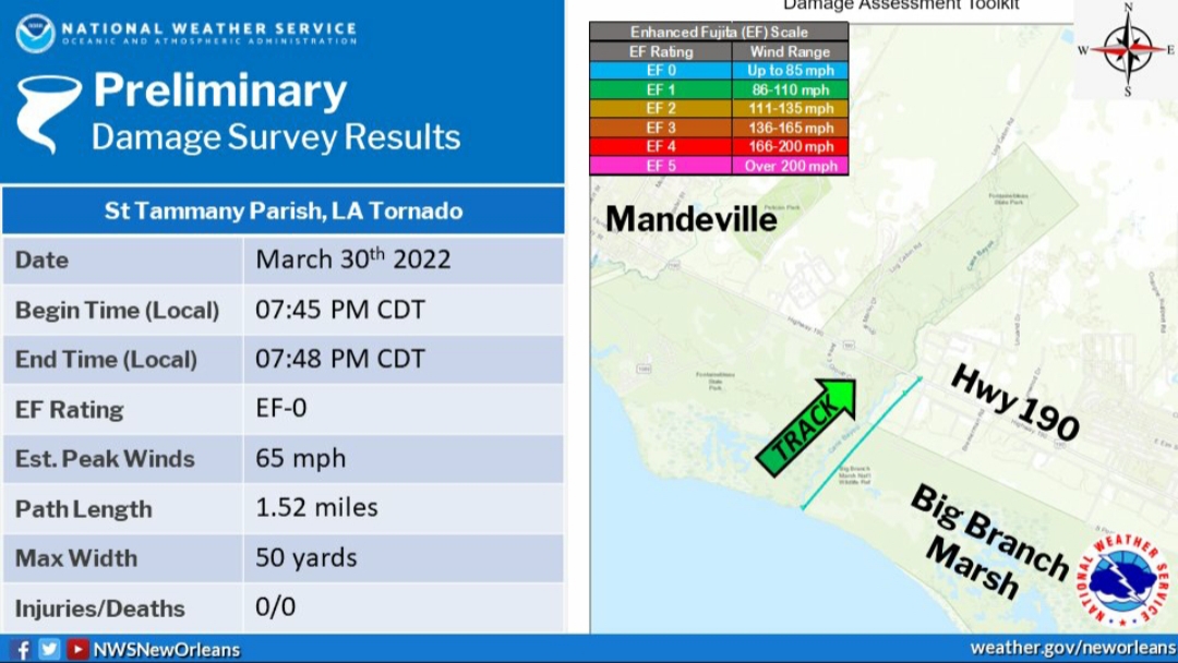
quote:
NWS Survey Team confirms an EF-0 tornado just east of Cane Bayou south of U.S. 190.
***In a most unbelievable coincidence, the track of this tornado from Lake Pontchartrain to 190 is nearly identical to one last week. In fact, we found different tree damage in the same yard!*** LINK

 Page 89 of 92

Popular
Back to top