- My Forums
- Tiger Rant
- LSU Recruiting
- SEC Rant
- Saints Talk
- Pelicans Talk
- More Sports Board
- Fantasy Sports
- Golf Board
- Soccer Board
- O-T Lounge
- Tech Board
- Home/Garden Board
- Outdoor Board
- Health/Fitness Board
- Movie/TV Board
- Book Board
- Music Board
- Political Talk
- Money Talk
- Fark Board
- Gaming Board
- Travel Board
- Food/Drink Board
- Ticket Exchange
- TD Help Board
Customize My Forums- View All Forums
- Show Left Links
- Topic Sort Options
- Trending Topics
- Recent Topics
- Active Topics
Started By
Message

 1
1

Posted on 3/30/22 at 12:48 pm to deltaland
quote:
Shocked it’s all in Louisiana and nothing in Arkansas yet
One of our outside salesmen sent some pics of pretty bad damage in Springdale an hour or two ago
Posted on 3/30/22 at 12:49 pm to Jim Rockford
I live in grant parish power is out and the lines that are down caught the woods on fire
Posted on 3/30/22 at 12:50 pm to DVinBR
I'm in the greater Memphis area. I know everyone here is focused mainly only TX, LA, and south Mississippi but looks like things are gonna fire up pretty quickly around 4pm.
Posted on 3/30/22 at 12:51 pm to LegendInMyMind
These are the two areas/timeframe we should be most concerned with in regards to cells out front of the line:
Starting in an hour or so in N. MS and later this evening into SE MS and SW AL.
Starting in an hour or so in N. MS and later this evening into SE MS and SW AL.
This post was edited on 3/30/22 at 12:56 pm
Posted on 3/30/22 at 12:52 pm to rt3
reposting for anyone who missed it a couple pages back...
KALB live stream as storms move into CenLA
KALB live stream as storms move into CenLA
This post was edited on 3/30/22 at 12:53 pm

Posted on 3/30/22 at 12:53 pm to LegendInMyMind
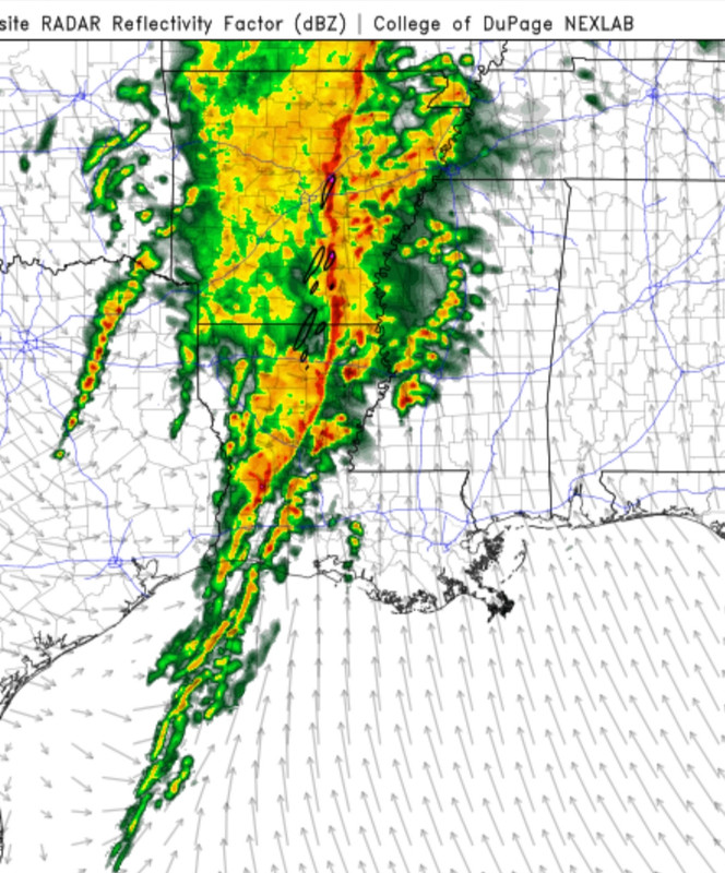
Anyone found any pictures of this moving through? Im curious if it has that mothership structure with the high wind associated with it.

Posted on 3/30/22 at 12:53 pm to rt3
Thanks for the link, pretty sure satellite in Bunkie wont be with signal much longer. Business is picking up here.

Posted on 3/30/22 at 12:53 pm to rt3
Probably time to check on in-laws @ Lake St John.
Posted on 3/30/22 at 12:54 pm to rt3
Hattiesburg, Laurel, and Tuscaloosa have all broken 80° with dews in the low 60s. Greenville is up to 79 and Columbus is at 77.
Posted on 3/30/22 at 12:55 pm to 50_Tiger
quote:
Anyone found any pictures of this moving through? Im curious if it has that mothership structure with the high wind associated with it.
Probably has that big shelf cloud look to it.

Posted on 3/30/22 at 12:56 pm to EagleEye99
I’m counting 10 warnings in Louisiana. Yikes.
Posted on 3/30/22 at 12:56 pm to LegendInMyMind
for you Windows computer people... to get °... hold down the ALT key while typing 0176
77° currently here according to my weather app thingy
77° currently here according to my weather app thingy

Posted on 3/30/22 at 12:57 pm to LegendInMyMind
I’m at 81°/67° in my hood
Posted on 3/30/22 at 12:58 pm to Abstract Queso Dip
quote:
I'm in the greater Memphis area. I know everyone here is focused mainly only TX, LA, and south Mississippi but looks like things are gonna fire up pretty quickly around 4pm.
Memphis has a window where they could be dealing with more than just the line. The greater threat for cells is a bit South, but your threat is still there.
Posted on 3/30/22 at 12:58 pm to LegendInMyMind
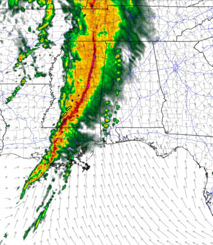
Fwiw, this is what the line looked like last week as it crossed into BR. Those storms eventually dropped the Arabi tornado.

That’s pretty similar to the simulated reflectivity we’re seeing on the short range models for today as well, like the Legend pic to which I’m replying.
That’s pretty similar to the simulated reflectivity we’re seeing on the short range models for today as well, like the Legend pic to which I’m replying.
Posted on 3/30/22 at 12:58 pm to trussthetruzz
79 here. Dewpoint 64
Posted on 3/30/22 at 1:00 pm to trussthetruzz
So far the QLCS anywhere north of Louisiana is a nothingburger. That can change though
Posted on 3/30/22 at 1:00 pm to LegendInMyMind
Gumbo Wx - Looking At The Current Features Producing This Line of Storms
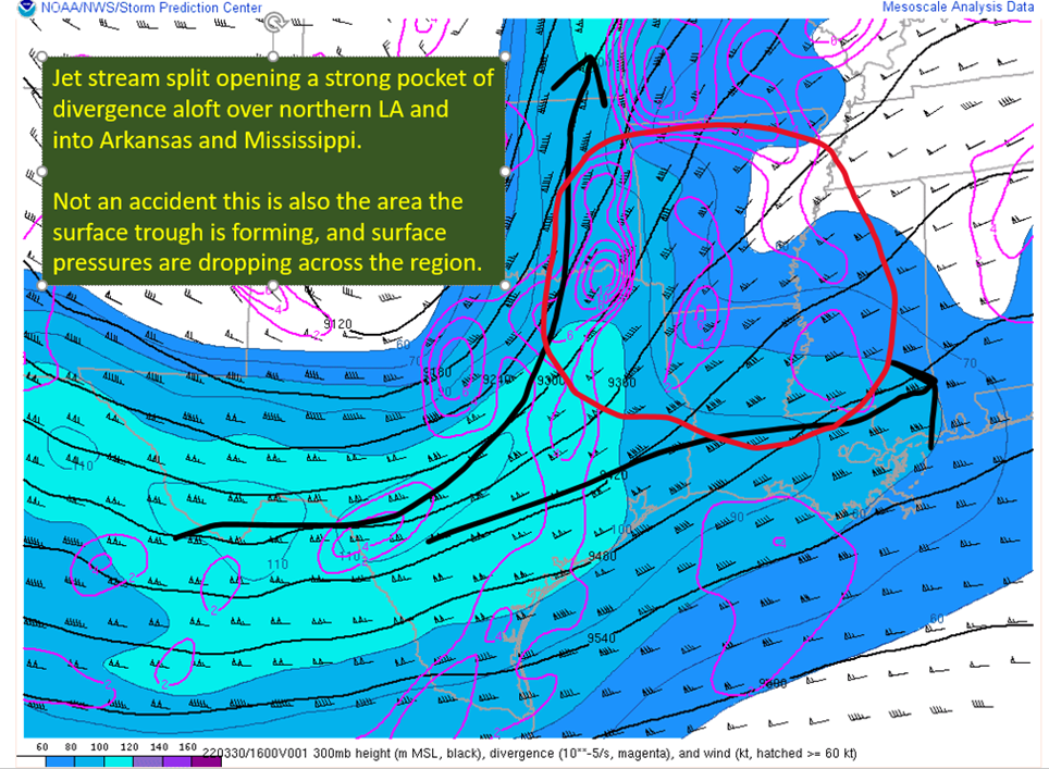
Not much forecasting or messaging here, just a look at what's happening at the surface and above.
Not much forecasting or messaging here, just a look at what's happening at the surface and above.
Posted on 3/30/22 at 1:01 pm to deltaland
sounds like Lake Charles is going to let the tornado warnings for the storms heading into Rapides & Vernon Parishes expire in favor of severe thunderstorm warnings with tornado possible tags

 Page 31 of 92

Popular
Back to top