




- My Forums
- Tiger Rant
- LSU Recruiting
- SEC Rant
- Saints Talk
- Pelicans Talk
- More Sports Board
- Fantasy Sports
- Golf Board
- Soccer Board
- O-T Lounge
- Tech Board
- Home/Garden Board
- Outdoor Board
- Health/Fitness Board
- Movie/TV Board
- Book Board
- Music Board
- Political Talk
- Money Talk
- Fark Board
- Gaming Board
- Travel Board
- Food/Drink Board
- Ticket Exchange
- TD Help Board
Customize My Forums- View All Forums
- Show Left Links
- Topic Sort Options
- Trending Topics
- Recent Topics
- Active Topics
Started By
Message
re: Laura - President Trump visits Lake Charles, Louisiana for Hurricane Response Update
Posted on 8/25/20 at 1:18 am to Prominentwon


Posted on 8/25/20 at 1:18 am to Prominentwon
Really want to see the rainfall total estimates now with the west shift. I’d bet us here in Lafayette are now in the bullseye for the flooding rain bands.
 1
1


Posted on 8/25/20 at 1:19 am to rds dc
the models flipping like this could spell an extremely dangerous situation for houston if it does head that way as a major hurricane, that's a frick ton of people having to evacuate in a short notice, way bigger than new orleans and katrina
Posted on 8/25/20 at 1:22 am to rds dc
quote:
?
Hurricane Tracker App
@hurrtrackerapp
·
2m
We are very concerned about the HOU/Galveston area. Tonight the models shifted west into the Houston area. The data is also showing a major hurricane strike is likely, maybe even a category 4. Follow future NHC forecasts if in HOU area. Here’s the new 0Z EURO


Posted on 8/25/20 at 1:26 am to Duke
Odds of losing power in BR with this current track? Can’t remember the last time a hurricane this strong had Baton Rouge on the east side (although outside the cone). I know Gustav is the obvious answer. Shoot, we lost power for a few hours during freaking Barry haha.
Posted on 8/25/20 at 1:38 am to Sev09
I’m in BR and I don’t think we will have much wind here. Maybe some flooding.
It’s looks like the new COC SW of most of the projected tracks takes NOLA out the woods and a bullseye on Galveston or Houston.
That being said rainfall projections for laffy and BR should increase a bit. Just my humble uneducated observation.
It’s gonna be a shite show if a cat 4/5 is bearing down on Houston and evac triggers are pulled. I pray for everyone in Laura’s path.
It’s looks like the new COC SW of most of the projected tracks takes NOLA out the woods and a bullseye on Galveston or Houston.
That being said rainfall projections for laffy and BR should increase a bit. Just my humble uneducated observation.
It’s gonna be a shite show if a cat 4/5 is bearing down on Houston and evac triggers are pulled. I pray for everyone in Laura’s path.
This post was edited on 8/25/20 at 1:42 am
Posted on 8/25/20 at 1:50 am to GeauxTigers80
quote:
Eric Webb
@webberweather
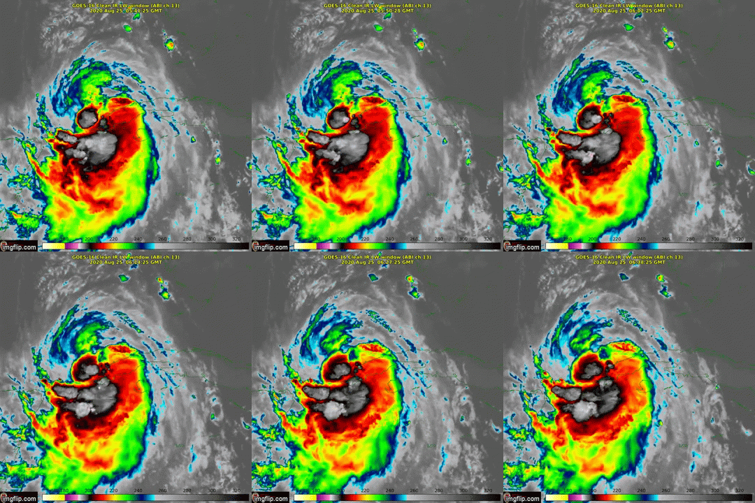
I have a suspicion that we're gonna see another SW shift in the models w/ #Laura later today. The last recon center fix placed #Laura's center on the SW edge of today's 12z Euro ensemble. This is likely bad news for folks on the TX coast, esp from Galveston to Port O'Connor

Posted on 8/25/20 at 2:06 am to Bobby OG Johnson
That just looks evil, and slowing

Posted on 8/25/20 at 2:15 am to Bobby OG Johnson
quote:
Eric Webb
@webberweather
Based on recent trends w/ #Laura & the steering pattern influencing it, I think #Laura will most likely make landfall somewhere between Freeport & Port O'Connor, TX as a category 3 or 4 hurricane, potentially putting Houston in the strongest right-front quad. We shall see...
Well that'd be one hell of a forecast path change in a short time.
This post was edited on 8/25/20 at 2:17 am

Posted on 8/25/20 at 2:17 am to Magic Helmet
quote:
I long for the days of Stu Ostro and Dr. Steve Lyons on the weather channel. What happened to those guys??
Stu is still there behind the scenes. He's the senior director of weather communications.
Steve is the meteorologist in charge at NWS San Angelo

Posted on 8/25/20 at 2:24 am to Lsuhoohoo
Makes me think he is fearcasting some. So that would mean in the matter of a few hours the track shifted over 100 miles. Guess he is thinking that ridge is stronger than expected.
Posted on 8/25/20 at 2:47 am to rt3
I love the wind.
Posted on 8/25/20 at 3:04 am to jcaz
Hold on are they saying it’s changed course now and heading for Galveston?
Posted on 8/25/20 at 3:08 am to Double Oh
No... but 8:00 am is a very important update


Posted on 8/25/20 at 3:09 am to Double Oh
It’s never really changed course that much. That area was always in the cone and within danger. The talk had been if it strengthens that it would be headed further west than if it was 1 or 2.
Some of the models that were posted on here Friday/Saturday had predicted a really strong storm directly at that area. And over the last 36 hours, most of the people on here who seem knowledgeable of the situation based on information they were seeing said expect it to push west.
Some of the models that were posted on here Friday/Saturday had predicted a really strong storm directly at that area. And over the last 36 hours, most of the people on here who seem knowledgeable of the situation based on information they were seeing said expect it to push west.
Posted on 8/25/20 at 3:13 am to biohzrd
quote:
LA**
Makes me think he is fearcasting some. So that would mean in the matter of a few hours the track shifted over 100 miles. Guess he is thinking that ridge is stronger than expected.
It is. Multiple Mets including Levi and Ryan Maue have been hinting at a further west track for 2 days. Bamwx a paid site for Ag weather put out their own track yesterday afternoon and it’s similar to current Euro
If it goes to Houston would be total failure for hurricane center and will cost lives
Posted on 8/25/20 at 3:14 am to fightingtigers98
Houston was out of cone Sunday afternoon for 2 updates
Posted on 8/25/20 at 3:22 am to Midtiger farm
Weather channel update not until 5:00 am.
What will New Orleans get out of this? Light rain and gusty winds? Thinking about heading there.
What will New Orleans get out of this? Light rain and gusty winds? Thinking about heading there.
Posted on 8/25/20 at 3:53 am to DVinBR
If I'm in Beaumont at a hotel, would i be better off just staying here or driving home to Gonzales, La?

 Page 286 of 815

Popular
Back to top
 Follow TigerDroppings for LSU Football News