- My Forums
- Tiger Rant
- LSU Recruiting
- SEC Rant
- Saints Talk
- Pelicans Talk
- More Sports Board
- Fantasy Sports
- Golf Board
- Soccer Board
- O-T Lounge
- Tech Board
- Home/Garden Board
- Outdoor Board
- Health/Fitness Board
- Movie/TV Board
- Book Board
- Music Board
- Political Talk
- Money Talk
- Fark Board
- Gaming Board
- Travel Board
- Food/Drink Board
- Ticket Exchange
- TD Help Board
Customize My Forums- View All Forums
- Show Left Links
- Topic Sort Options
- Trending Topics
- Recent Topics
- Active Topics
Started By
Message
 2
2

Posted on 9/21/22 at 9:22 am to Areddishfish
quote:
Now AL and MS are in play.
I feel like a dick, but after Ida last year I would be content with it staying on its current track
Posted on 9/21/22 at 9:22 am to Areddishfish
quote:
When I looked the other day there was one model spinning off in that direction compared to now haha
look harder, and at other ensemble models.
hell some of them have had this thing staying week and slamming into the yucatan for a bit
Posted on 9/21/22 at 9:22 am to Areddishfish
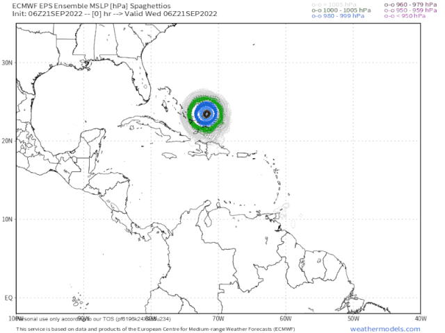
More consolidation at the Yucatan/Cuba gap with the 06z EPS run.
Compare that to the 144 hr mark of the 0z EPS
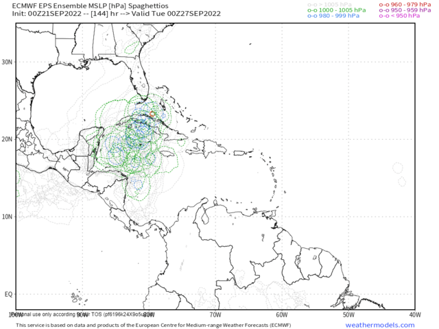
Compare that to the 144 hr mark of the 0z EPS
Posted on 9/21/22 at 9:23 am to gaetti15
Hopefully this storm is different but historically they usually all push more westward when entering the gulf.

Posted on 9/21/22 at 9:25 am to purple18
quote:
historically they usually all push more westward when entering the gulf.
Not this late in September. Historically they go into Florida this time of year. Obviously there are exception but for the most part, the pattern changes this time of year usually push them more eastward.
Now if that ridge continues to strengthen…
Posted on 9/21/22 at 9:26 am to lsugolfredman
The Canadian (I know) has this thing due south of NOLA on October 1, albeit much weaker than some of the other models.

Posted on 9/21/22 at 9:27 am to TDsngumbo
What ridge, and what happens if it strengthens?

Posted on 9/21/22 at 9:29 am to Legion of Doom
If another hits any part of LA we all may never be able to get homeowners insurance ever again
Posted on 9/21/22 at 9:30 am to maisweh
quote:
I feel like a dick
How do you know what a dick feels like?

Posted on 9/21/22 at 9:31 am to TDsngumbo
quote:
Now if that ridge continues to strengthen…
Yes. All Louisiana interests will be praying for that ridge to be weaker.
Posted on 9/21/22 at 9:38 am to TDsngumbo
quote:
Not this late in September. Historically they go into Florida this time of year.
Well I remember September 18th 2005 and a little gal named Rita that F'd up SWLA
Posted on 9/21/22 at 9:39 am to stout
quote:
Well I remember September 18th 2005 and a little gal named Rita that F'd up SWLA
well this is in theory hitting at the end of September, beginning of October...slightly different
Posted on 9/21/22 at 9:39 am to TDsngumbo
Zeta says hello
Posted on 9/21/22 at 9:40 am to Legion of Doom
quote:
What ridge, and what happens if it strengthens?
Models are projecting a ridge to develop over the southeast around the same time but it’s weak enough to allow a strong storm to penetrate it. The last few runs have built the ridge a tad stronger which is why they have it going closer to the panhandle (doing its best to push it west but it’s just not strong enough to push it far west). If the ridge does indeed develop and it gets stronger, the system could be pushed further west. If the front is strong enough, depending on the timing, that could erode the ridge making all this irrelevant and the system would go much further East.
As always, nobody knows jack shite at this point because none of these things even exist yet
This post was edited on 9/21/22 at 9:42 am
Posted on 9/21/22 at 9:40 am to UpToPar
quote:
albeit much weaker than some of the other models.
What is that like a 1?
Posted on 9/21/22 at 9:41 am to DVinBR
quote:
Zeta says hello
Yea I know, that’s why I said there are obvious exceptions but historically speaking, this time of the year is Florida’s west coast’s time to “shine”.
Posted on 9/21/22 at 9:41 am to DVinBR
quote:
Zeta says hello
you can find all sorts of anomalies with climatological trends, doesn't change the fact that the average location of storm hits shifts east toward Florida as you get further into September and October....why is that?
Likelihood and strength of cold fronts in the South increases as you get further into Fall. Cold fronts move West to East
Posted on 9/21/22 at 9:42 am to maisweh
Canadian model has been dog shite all year. The Euro has seemed to be the best this year. Once a center forms the pucker factor will either go up or down.

Posted on 9/21/22 at 9:43 am to stout
quote:
Well I remember September 18th 2005 and a little gal named Rita that F'd up SWLA
For weather pattern changes, these two weeks make a difference. Usually, the first cool front comes down around the 25th, which is the beginning of the fall pattern change.
The 18th is unfortunately before that pattern flip which is why Rita smoked us. Those 2 weeks really do make a difference, most of the time.

 Page 34 of 465

Popular
Back to top