- My Forums
- Tiger Rant
- LSU Recruiting
- SEC Rant
- Saints Talk
- Pelicans Talk
- More Sports Board
- Fantasy Sports
- Golf Board
- Soccer Board
- O-T Lounge
- Tech Board
- Home/Garden Board
- Outdoor Board
- Health/Fitness Board
- Movie/TV Board
- Book Board
- Music Board
- Political Talk
- Money Talk
- Fark Board
- Gaming Board
- Travel Board
- Food/Drink Board
- Ticket Exchange
- TD Help Board
Customize My Forums- View All Forums
- Show Left Links
- Topic Sort Options
- Trending Topics
- Recent Topics
- Active Topics
Started By
Message
re: Ian Observation Thread (Storm Track and Radar inside)
Posted on 9/26/22 at 6:32 pm to ForLSU56
Posted on 9/26/22 at 6:32 pm to ForLSU56
quote:
If it hits during normal high tide time, it could get even uglier.
High tide is 6:10 pm Thursday and is the weaker of the 2 high tides that day at 2.3'.
Fri morning the high tide is at 4:26 am at 3.28'.
 1
1


Posted on 9/26/22 at 6:32 pm to LSUintheNW
Moved to Sarasota last year, and bought a house here in May... We are going to stick it out I think. We have our hurricane shutters up, and hoping for a late shift. Not looking great right now.
Posted on 9/26/22 at 6:35 pm to DrewDawg13
Better safe than brave Drew. GTFO. Your pride isn’t worth it.
Shutters mean nothing with storm surge.
Shutters mean nothing with storm surge.
This post was edited on 9/26/22 at 6:36 pm
Posted on 9/26/22 at 6:36 pm to Oates Mustache
quote:
Jamaican Model)

Posted on 9/26/22 at 6:39 pm to alphaandomega
quote:
Put one in Gitmo for the southern areas and another one near Havana for the north. Promise to share weather data.
They -- we -- may not want to show it, but GTMO has plenty of surveillance equipment of many types.
If it ain't on Spook Hill, we probably don't need it.
Posted on 9/26/22 at 6:39 pm to Oates Mustache
If anybody deserves blame it's the dumbass local weather guy who wrote a story with this headline for a Tampa news outlet in April:
quote:
Tampa Bay has dodged Florida’s catastrophic hurricanes, but for how much longer?
Posted on 9/26/22 at 6:40 pm to Roll Tide Ravens
Upper, Mid, and Low level water vapor. I can't make/post gifs for shite, so screenshots it is.
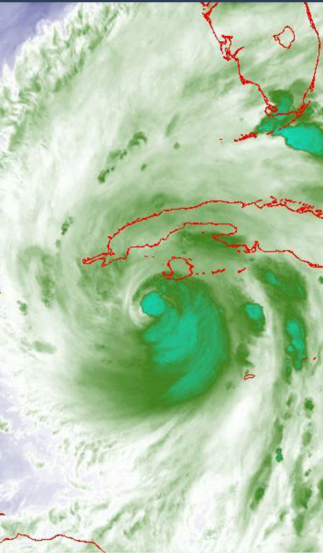
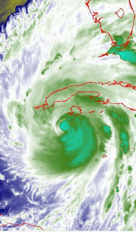
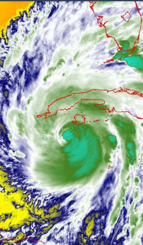

Posted on 9/26/22 at 6:43 pm to LegendInMyMind
I was just looking at those, as well. It looks like there may be at least a bit of dry air on the western side of the center. Will it mix out or hamper strengthening is the question?
Posted on 9/26/22 at 6:46 pm to Bobby OG Johnson
quote:
FL Division of Emergency Management
@FLSERT
Mon. 9/26/22, 7:30PM EST: Hurricane warnings are in effect for Hillsborough, Manatee, Pinellas & Sarasota counties. Hurricane watches are also in effect for areas along the Gulf Coast.
Residents should prep for #Ian impacts & have multiple ways to receive weather alerts.


Posted on 9/26/22 at 6:46 pm to Roll Tide Ravens
I, personally, don't think it will hurt much. Philippe Pappin has a couple good tweets that could give some tips as to what is going on. It may have gone through a sort of EWRC earlier today that set the stage for the spiral band around the eye we see now. Some dry air could have slipped in during that process and will likely cycle out without hampering the storm too much.
This post was edited on 9/26/22 at 6:48 pm
Posted on 9/26/22 at 6:50 pm to Bobby OG Johnson
This Justin Michaels guy on TWC is annoying. He is the perfect illustration of a TV news goob.
Posted on 9/26/22 at 6:55 pm to Roll Tide Ravens
quote:
I was just looking at those, as well.
If you want a bigger picture look than what Tropical Tidbits shows, that wX app I always recommend has a bunch of satellite products, pretty much most of the GOES stuff.
It is easier than tracking it down on websites.
This post was edited on 9/26/22 at 6:56 pm
Posted on 9/26/22 at 6:59 pm to LegendInMyMind
Sweet, I’ll check that out. Thanks!
Posted on 9/26/22 at 7:00 pm to Roll Tide Ravens
New intermediate advisory (no new cone for this advisory). Winds still at 100mph, pressure down to 965mb.
Hurricane Ian Intermediate Advisory Number 15A
NWS National Hurricane Center Miami FL AL092022
800 PM EDT Mon Sep 26 2022
...CONDITIONS IN WESTERN CUBA BEGINNING TO DETERIORATE WITH
SIGNIFICANT WIND AND STORM SURGE IMPACTS EXPECTED OVERNIGHT...
SUMMARY OF 800 PM EDT...0000 UTC...INFORMATION
----------------------------------------------
LOCATION...20.8N 83.3W
ABOUT 130 MI...205 KM SE OF THE WESTERN TIP OF CUBA
MAXIMUM SUSTAINED WINDS...100 MPH...155 KM/H
PRESENT MOVEMENT...NNW OR 330 DEGREES AT 13 MPH...20 KM/H
MINIMUM CENTRAL PRESSURE...965 MB...28.50 INCHES
This post was edited on 9/26/22 at 7:01 pm
Posted on 9/26/22 at 7:00 pm to Bobby OG Johnson

Posted on 9/26/22 at 7:02 pm to Bobby OG Johnson
Psssshhhh....that's nonsense, Bobby. Space doesn't exist.

Posted on 9/26/22 at 7:06 pm to Bobby OG Johnson
Those airplanes should drop a wine bottle with a hurricane drink recipe and a 100 dollar bill and a tracker for scientific research.
This post was edited on 9/26/22 at 7:07 pm
Posted on 9/26/22 at 7:08 pm to LegendInMyMind
quote:
Psssshhhh....that's nonsense, Bobby. Space doesn't exist.


 Page 187 of 465

Popular
Back to top