- My Forums
- Tiger Rant
- LSU Recruiting
- SEC Rant
- Saints Talk
- Pelicans Talk
- More Sports Board
- Fantasy Sports
- Golf Board
- Soccer Board
- O-T Lounge
- Tech Board
- Home/Garden Board
- Outdoor Board
- Health/Fitness Board
- Movie/TV Board
- Book Board
- Music Board
- Political Talk
- Money Talk
- Fark Board
- Gaming Board
- Travel Board
- Food/Drink Board
- Ticket Exchange
- TD Help Board
Customize My Forums- View All Forums
- Show Left Links
- Topic Sort Options
- Trending Topics
- Recent Topics
- Active Topics
Started By
Message
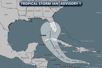
re: Ian Observation Thread (Storm Track and Radar inside)
Posted on 9/25/22 at 7:35 am to Gene Heinous

Posted on 9/25/22 at 7:35 am to Gene Heinous
This was the 06z spaghetti model run


 3
3

Posted on 9/25/22 at 7:38 am to LanierSpots
The concern I have right now is we still don’t have a great idea on where the center of this thing is (because it still ain’t stacked as of the 5am update) and it’s actual motion is still uncertain.
I still believe the GFS and Euro are setting the west and east edges of the path but man, it would be nice if some things could get locked down.
Or not, keep the thing a sloppy mess that never develops, that would be fine.
I still believe the GFS and Euro are setting the west and east edges of the path but man, it would be nice if some things could get locked down.
Or not, keep the thing a sloppy mess that never develops, that would be fine.
This post was edited on 9/25/22 at 7:39 am
Posted on 9/25/22 at 7:41 am to Roll Tide Ravens
This isn't the most ideal scenario from EMA directors all the way to the average citizen. The difference in the two options is pretty significant in regards to planning and possible response.
If it hooks and comes in closer to Tampa, or farther South, it'll be a good bit stronger at landfall. This puts really everywhere from the panhandle to South of Tampa in a bind with very little time to implement a plan.
Really, if you live down that way you have to prepare for all scenarios. We need something to give and things to come together. This is too big of a spread the closer we get.
Posted on 9/25/22 at 7:57 am to mightynine
Looks like Ian is poised to strenthen in the near term, it's getting that look
Posted on 9/25/22 at 8:02 am to lsuman25
The longer it stays disorganized the more westerly the track becomes or what?
Posted on 9/25/22 at 8:10 am to BananaManCan
quote:
The longer it stays disorganized the more westerly the track becomes or what?
Not necessarily. It matters where, exactly, it is when it gets its act completely together. If it is a bit Southwest of where it is currently, that influences the path to landfall and vice versa.
It looks like we should solve that riddle over the next several hours.
ETA: but that's not really the biggest issue at play right now regarding the ultimate US landfall. It has more to do with the steering as it approaches Cuba and starts to make the turn. Everything up to Cuba looks pretty similar as far as the Euro and GFS goes.
This post was edited on 9/25/22 at 8:13 am

Posted on 9/25/22 at 8:11 am to Roll Tide Ravens
CEM2 can die in a tire fire
Posted on 9/25/22 at 8:13 am to LSUTiger23
So 00z is 7pm central time
Posted on 9/25/22 at 8:14 am to SlidellCajun
quote:
So 00z is 7pm central time
This time of year, yes. When they dick with the clocks again it will be 6pm.

Posted on 9/25/22 at 8:20 am to LegendInMyMind
Flying to the coastal area on NC today for a wedding this week. Have tickets to watch SC play in Columbia next sat. Looking like my flight out of Charlotte next Sunday will be a little bumpy.....

Posted on 9/25/22 at 8:22 am to Bobby OG Johnson
Posted on 9/25/22 at 8:24 am to Roll Tide Ravens
CEM2 can EABOD.
Posted on 9/25/22 at 8:24 am to Bobby OG Johnson
Not the best of storms to unveil the new, skinnier cone on. 

Posted on 9/25/22 at 8:29 am to Bobby OG Johnson
At least the 8 to 9 was a small change.
Posted on 9/25/22 at 8:30 am to Bobby OG Johnson
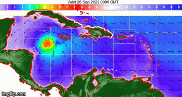
quote:
NHC_TAFB
@NHC_TAFB
Forecast winds (kt-barbs) and waves (ft-shaded) for Tropical Storm Ian. Ian is forecast to rapidly intensify as it moves across the NW Caribbean through Monday. Seas will build in excess of 25 ft south of Cuba by Monday.
Posted on 9/25/22 at 8:30 am to LegendInMyMind
quote:
Not the best of storms to unveil the new, skinnier cone on.
TBF, the NHC has been honest about the uncertainty for the track, especially days 4-5, since the start.
I wonder if, when there’s that much uncertainty, if they should issue just a three-day cone.
Posted on 9/25/22 at 8:33 am to Lonnie Utah
quote:
Flying to the coastal area on NC today for a wedding this week. Have tickets to watch SC play in Columbia next sat. Looking like my flight out of Charlotte next Sunday will be a little bumpy.....
hehe thx for sharing dude. you are cool
Posted on 9/25/22 at 8:33 am to Lonnie Utah
quote:
Flying to the coastal area on NC today for a wedding this week. Have tickets to watch SC play in Columbia next sat. Looking like my flight out of Charlotte next Sunday will be a little bumpy.....
Cool
What are you doing the week after that?
Posted on 9/25/22 at 8:33 am to mightynine
quote:
TBF, the NHC has been honest about the uncertainty for the track, especially days 4-5, since the start.
Yeah, I'm not blaming them. This is a pain in the arse system to forecast.
quote:
I wonder if, when there’s that much uncertainty, if they should issue just a three-day cone.
That's not a terrible idea. They could note the uncertainty, give the three day cone, and then do a probabilistic outlook for down the line similar to the SPC day 4-8 outlook.
Posted on 9/25/22 at 8:35 am to mightynine
quote:
I wonder if, when there’s that much uncertainty, if they should issue just a three-day cone.
Just make a wider cone or just pencil whip one in after the fact.

 Page 146 of 465

Popular
Back to top