- My Forums
- Tiger Rant
- LSU Recruiting
- SEC Rant
- Saints Talk
- Pelicans Talk
- More Sports Board
- Coaching Changes
- Fantasy Sports
- Golf Board
- Soccer Board
- O-T Lounge
- Tech Board
- Home/Garden Board
- Outdoor Board
- Health/Fitness Board
- Movie/TV Board
- Book Board
- Music Board
- Political Talk
- Money Talk
- Fark Board
- Gaming Board
- Travel Board
- Food/Drink Board
- Ticket Exchange
- TD Help Board
Customize My Forums- View All Forums
- Show Left Links
- Topic Sort Options
- Trending Topics
- Recent Topics
- Active Topics
Started By
Message
re: Hurricane Nate - Moving Inland - Hurricane Season Over?
Posted on 10/4/17 at 6:46 am to OGJangalang
Posted on 10/4/17 at 6:46 am to OGJangalang
000
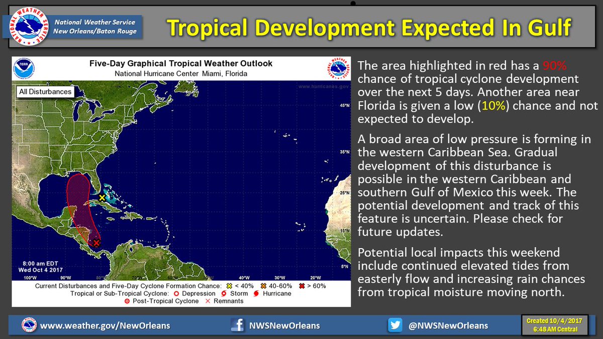
ABNT20 KNHC 041144
TWOAT
Tropical Weather Outlook
NWS National Hurricane Center Miami FL
800 AM EDT Wed Oct 4 2017
For the North Atlantic...Caribbean Sea and the Gulf of Mexico:
Showers and thunderstorms associated with an area of low pressure
located over the southwestern Caribbean Sea have become better
organized since yesterday. This system is expected to become a
tropical depression later today while it moves northwestward toward
the coast of Nicaragua. The low should move slowly northwestward
across or near the eastern portions of Nicaragua and Honduras on
Thursday, move into the northwestern Caribbean Sea by Friday, and
emerge over the southern Gulf of Mexico by Saturday. Interests in
Nicaragua, Honduras, the Yucatan peninsula and western Cuba should
monitor the progress of this system as watches or warnings could be
issued later today. An Air Force Reserve reconnaissance aircraft is
scheduled to investigate the disturbance this afternoon. Regardless
of development, this system will produce heavy rains over portions
of Central America during the next few days, likely causing flash
floods and mudslides.
* Formation chance through 48 hours...high...90 percent.
* Formation chance through 5 days...high...90 percent.
 0
0

Posted on 10/4/17 at 6:55 am to GEAUXmedic
quote:
06z GFS
Looking at the vorticity fields, that run is all kinds of messed up


Posted on 10/4/17 at 6:57 am to rds dc
quote:
Looking at the vorticity fields, that run is all kinds of messed up
The 00z was a mess too.
Posted on 10/4/17 at 7:01 am to rds dc
Euro has a slower mover it looks like.
GFS also has apparently just given up on hurricane season.
GFS also has apparently just given up on hurricane season.
Posted on 10/4/17 at 7:06 am to rds dc
Storms firing near the estimated center this morning

Posted on 10/4/17 at 7:09 am to rds dc
Damnit guys. I saw the GFS and got hopeful. Then check back and y’all shite all over it.
I just want some hope!
I just want some hope!

Posted on 10/4/17 at 7:12 am to rds dc
Euro has been way more accurate than GFS this year.
Posted on 10/4/17 at 7:12 am to rds dc
Why the drastic difference in speed? GFS has it moving twice as fast.
Posted on 10/4/17 at 7:12 am to Duke
So ignore GFS?
Posted on 10/4/17 at 7:13 am to Dizz
For now
Posted on 10/4/17 at 7:32 am to Dizz
quote:
So ignore GFS?
Until it starts making sense again.
Posted on 10/4/17 at 7:43 am to rds dc
quote:
Looking at the vorticity fields, that run is all kinds of messed up
GFS got drunk last night I see
Posted on 10/4/17 at 7:52 am to rds dc
Can't catch a break this year.

Posted on 10/4/17 at 7:52 am to rds dc
If this thing were to make landfall in Louisiana, when would south la or nola start feeling effects? I’m supposed to be leaving town tomorrow through Sunday. Should I plan to be back Saturday?

Posted on 10/4/17 at 8:03 am to tgrbaitn08
well fak this thing is a quick mover....thought id dodge a bullet. going to gulf shores this wkend.
Posted on 10/4/17 at 8:26 am to tke857
GFS with a double circulation

Posted on 10/4/17 at 8:33 am to tke857
quote:
going to gulf shores this wkend
There will be waves there this weekend.

 Page 15 of 193

Popular
Back to top