- My Forums
- Tiger Rant
- LSU Recruiting
- SEC Rant
- Saints Talk
- Pelicans Talk
- More Sports Board
- Fantasy Sports
- Golf Board
- Soccer Board
- O-T Lounge
- Tech Board
- Home/Garden Board
- Outdoor Board
- Health/Fitness Board
- Movie/TV Board
- Book Board
- Music Board
- Political Talk
- Money Talk
- Fark Board
- Gaming Board
- Travel Board
- Food/Drink Board
- Ticket Exchange
- TD Help Board
Customize My Forums- View All Forums
- Show Left Links
- Topic Sort Options
- Trending Topics
- Recent Topics
- Active Topics
Started By
Message
 0
0

Posted on 9/19/17 at 11:56 am to 50_Tiger
quote:
Okay Duke, time to teach 50 something new. WTF is a hot tower
Wiki on Hot Towers
quote:
A hot tower is a tropical cumulonimbus cloud that penetrates the tropopause, i.e. it reaches out of the lowest layer of the atmosphere, the troposphere, into the stratosphere. In the tropics, the tropopause typically lies at least 15 kilometres (9.3 mi) above sea level. These towers are called "hot" because they rise high due to the large amount of latent heat released as water vapor condenses into liquid and freezes into ice.[1] The presence of hot towers with a tropical cyclone's eyewall can indicate strengthening is more likely during the next six hours.
Posted on 9/19/17 at 11:56 am to 50_Tiger
quote:
Okay Duke, time to teach 50 something new. WTF is a hot tower
Big arse convective burst. They look like wrinkly clouds on a sat image. Those burst cool the hell out of the warm air it's picking up (those black, grey, and even pink colors on IR showing super cold cloud tops), liberating all sorts of heat energy for work.
Seeing those indicates a storm is rapidly gaining strength.
To quote the article I shared with it:
quote:
Enough water vapor was condensing into rain inside of this cell that rapid updrafts developed, rapid enough to lift the precipitation until it froze and then even higher until it penetrated (lol) into the lower stratosphere at 16.75 km altitude," said Owen Kelley of NASA Goddard's Precipitation Processing System..
"This tall cell (also known as a "hot tower") was part of a sequence of such cells that were seen by infrared satellite instruments, such as the one on the recently launched GOES-16 satellite. Meanwhile, Maria put on an unexpectedly fast intensification from category 1 to category 3 on the Saffir-Simpson scale on Monday (Sept. 18)."
Research conducted at NASA, at the University of Maryland, Baltimore County, and elsewhere suggests that a sequence of hot towers, also known as a "convective burst," is one a way to detect that a hurricane's heat engine going into high gear. The end result is intensified winds circling the eye at the ocean's surface.
Posted on 9/19/17 at 11:57 am to slackster
Recon has left Curacao en route to Maria.

Posted on 9/19/17 at 11:58 am to Duke
Learn something new every day! Thanks guys! 
Posted on 9/19/17 at 12:03 pm to slackster
Venezuela prepares humanitarian aid for island of Dominica.


Trinidad and Tobago also announce they are sending assistance. They are sending the National Helicopter Services Limited helicopters and the T&T Defence Force personnel.
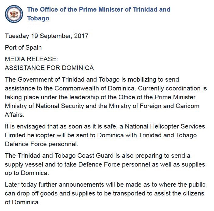
Listen to one of the last voices out of Dominica before communications went down overnight.
Trinidad and Tobago also announce they are sending assistance. They are sending the National Helicopter Services Limited helicopters and the T&T Defence Force personnel.
Listen to one of the last voices out of Dominica before communications went down overnight.
Posted on 9/19/17 at 12:04 pm to 50_Tiger
A bit of a silver lining here, but neither the GFS nor the Euro indicate any additional tropical activity over the next 10 days.
Posted on 9/19/17 at 12:08 pm to slackster
quote:
A bit of a silver lining here, but neither the GFS nor the Euro indicate any additional tropical activity over the next 10 days.
Aren't we coming down the mountain in terms of the season?
Posted on 9/19/17 at 12:12 pm to Duke
quote:
Big arse convective burst. They look like wrinkly clouds on a sat image. Those burst cool the hell out of the warm air it's picking up (those black, grey, and even pink colors on IR showing super cold cloud tops), liberating all sorts of heat energy for work.
Seeing those indicates a storm is rapidly gaining strength.
To quote the article I shared with it:
quote:
Enough water vapor was condensing into rain inside of this cell that rapid updrafts developed, rapid enough to lift the precipitation until it froze and then even higher until it penetrated (lol) into the lower stratosphere at 16.75 km altitude," said Owen Kelley of NASA Goddard's Precipitation Processing System..
"This tall cell (also known as a "hot tower") was part of a sequence of such cells that were seen by infrared satellite instruments, such as the one on the recently launched GOES-16 satellite. Meanwhile, Maria put on an unexpectedly fast intensification from category 1 to category 3 on the Saffir-Simpson scale on Monday (Sept. 18)."
Research conducted at NASA, at the University of Maryland, Baltimore County, and elsewhere suggests that a sequence of hot towers, also known as a "convective burst," is one a way to detect that a hurricane's heat engine going into high gear. The end result is intensified winds circling the eye at the ocean's surface.
Convective burst are still poorly understood and there is still a lot of uncertainty to what role they play in hurricane strengthening and maintenance but they appear play a key role. The problem with studying them is that they are storm scale features (smaller than mesoscale) that don't last very long. It appears that CBs closer to the center, with higher vertical velocities and higher rain rates are associated with better storm structure and chances for intensification. The other problem with them is that they can't be resolved by current computer models and can't be predicted. Maria is in a relatively low shear environment and the mesovorts in the eye (clearly seen on sat images) will play a role in future CBs since they can force mixing between the eye and eyewall.
Posted on 9/19/17 at 12:14 pm to rds dc
If she maintains same direction currently, St. Croix gonna need A LOT of help.
Posted on 9/19/17 at 12:14 pm to 50_Tiger
quote:
Aren't we coming down the mountain in terms of the season
Hurricane season peaks sharply in the middle of September, so yes, we are coming down the mountain.
This season, I won't feel comfortable until at least mid October.
Posted on 9/19/17 at 12:20 pm to slackster
Looks like a thread with good info. Thanks guys. I'm just lurking.
.... or maybe I could be the one to make it more interesting. Should I give you my gut feeling, cuss you out for the cone existence or because you are too dumb to use triangles. <- joking of course.
Thanks for sharing info.
.... or maybe I could be the one to make it more interesting. Should I give you my gut feeling, cuss you out for the cone existence or because you are too dumb to use triangles. <- joking of course.
Thanks for sharing info.
This post was edited on 9/19/17 at 12:34 pm

Posted on 9/19/17 at 12:32 pm to ihometiger
How the hell does Venezuela have anything to aid anyone with?
Posted on 9/19/17 at 12:41 pm to flyAU
quote:
How the hell does Venezuela have anything to aid anyone with?
I was thinking the same thing.

Posted on 9/19/17 at 12:45 pm to flyAU
quote:
How the hell does Venezuela have anything to aid anyone with?
Easy, they steal it from their own people to give to others.
Posted on 9/19/17 at 12:48 pm to slackster
I know these storms will wobble, but I don't recall a storm that has wobbled more than Maria:

I guess this was to be expected with a name like Maria.
I guess this was to be expected with a name like Maria.
Posted on 9/19/17 at 12:49 pm to slackster
Looks to be moving NW w/W booty shakes
Posted on 9/19/17 at 12:52 pm to slackster
A lot going on with those convective burst and wanes going on and the little eye shows all the little movements I suppose.

Keeping it SWF really limited my opportunities.
quote:
I guess this was to be expected with a name like Maria.
Keeping it SWF really limited my opportunities.
Posted on 9/19/17 at 12:53 pm to 50_Tiger
Got 2 planes going into Maria, one is low-level recon, the other one I would bet is an upper level dropsonde mission.
Posted on 9/19/17 at 12:55 pm to lsuman25

Hints of a second big eyewall showing up on radar now. Little dry slot on the NW side, looks like higer reflectivity wrapping around. Glad recon is inbound to confirm, since we don't have a full picture from SJ.
And yeah, I bet the second plane is sampling the upper levels to help the models out some.
This post was edited on 9/19/17 at 12:57 pm

 Page 22 of 43

Popular
Back to top