- My Forums
- Tiger Rant
- LSU Recruiting
- SEC Rant
- Saints Talk
- Pelicans Talk
- More Sports Board
- Coaching Changes
- Fantasy Sports
- Golf Board
- Soccer Board
- O-T Lounge
- Tech Board
- Home/Garden Board
- Outdoor Board
- Health/Fitness Board
- Movie/TV Board
- Book Board
- Music Board
- Political Talk
- Money Talk
- Fark Board
- Gaming Board
- Travel Board
- Food/Drink Board
- Ticket Exchange
- TD Help Board
Customize My Forums- View All Forums
- Show Left Links
- Topic Sort Options
- Trending Topics
- Recent Topics
- Active Topics
Started By
Message
re: Hurricane Iota - No Más! No Más! - Gulf Finally Closed?
Posted on 11/2/20 at 6:26 pm to Bobby OG Johnson
Posted on 11/2/20 at 6:26 pm to Bobby OG Johnson

 2
2


Posted on 11/2/20 at 6:34 pm to Duke
That's a great shot.
If it takes out takes out the Rocky Patel factory I reckon I will be giving up cigars.
If it takes out takes out the Rocky Patel factory I reckon I will be giving up cigars.

Posted on 11/2/20 at 6:34 pm to Duke
Really looks like a pinhole pacific typhoon
Posted on 11/2/20 at 6:35 pm to Cosmo
Yeah it does. Only part of this basin that can pull this off.
Posted on 11/2/20 at 6:41 pm to Duke
I’m going to do LA a favor and not go to the camp this weekend and get all our stuff hooked back up. Perhaps it’ll go away, I’m 0/3 otherwise.

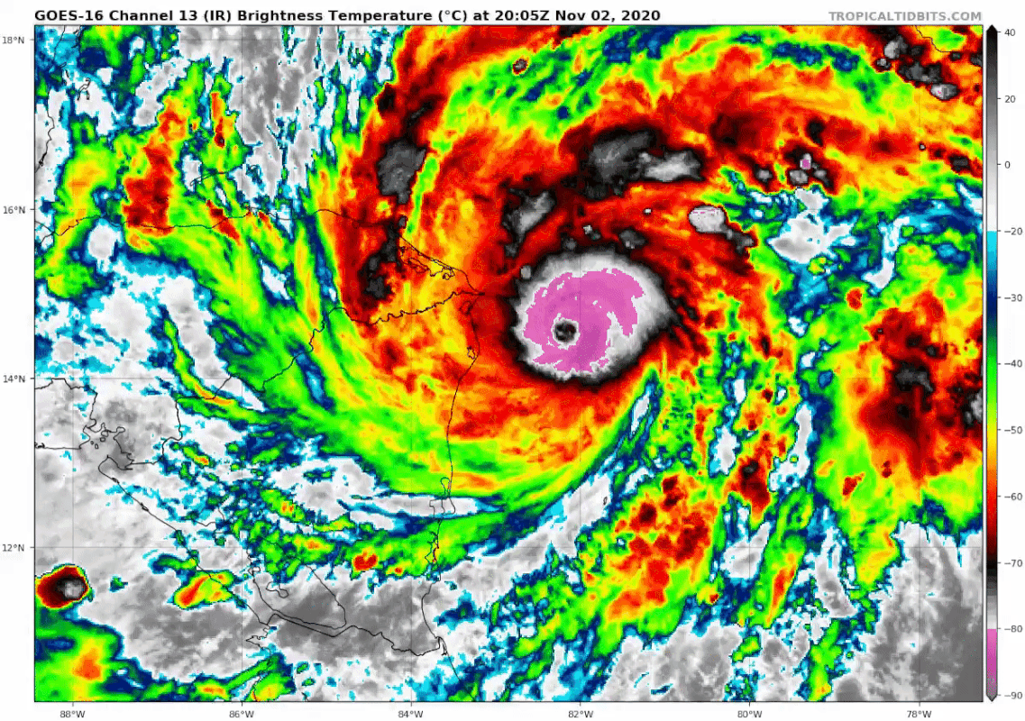
Posted on 11/2/20 at 6:47 pm to lsuman25
quote:
7:00 PM EST Mon Nov 2
Location: 14.4°N 82.4°W
Moving: WSW at 9 mph
Min pressure: 934 mb
Max sustained: 150 mph
Wtf
I don't check on this storm for 24 hours and it's turned into THIS?
Holy shite.
This post was edited on 11/2/20 at 6:48 pm
Posted on 11/2/20 at 6:51 pm to Hulkklogan
quote:
Wtf
I don't check on this storm for 24 hours and it's turned into THIS?
2020 doesn't let up.

frick'n hell.

This post was edited on 11/2/20 at 6:53 pm
Posted on 11/2/20 at 6:56 pm to Duke
Gonna be a long few days in that part of the world.
Posted on 11/2/20 at 6:58 pm to LegendInMyMind
Raw T# at 7.9. Bonkers for the Atlantic.

Lot of rain to get ringed out, and being on the coast for this wouldn't be a good time.
quote:
Gonna be a long few days in that part of the world.
Lot of rain to get ringed out, and being on the coast for this wouldn't be a good time.
Posted on 11/2/20 at 7:04 pm to Duke
Annular hurricane?
Posted on 11/2/20 at 7:05 pm to Duke
My mom is flying from Houston to Costa Rica Saturday morning. She is worried and she is thinking about canceling her flight.
Posted on 11/2/20 at 7:05 pm to Duke
Jack Sillin is pulling out the Dvorak. He says Eta is topped out a a T7.9 on Raw Satellite Intensity.
I don't have it in me tonight to dive into the Dvorak.
ETA: I hadn't read Duke's post right before I posted this.
I don't have it in me tonight to dive into the Dvorak.
ETA: I hadn't read Duke's post right before I posted this.
This post was edited on 11/2/20 at 7:07 pm
Posted on 11/2/20 at 7:06 pm to Cosmo
quote:
Annular hurricane?
You will get one one day.
Posted on 11/2/20 at 7:07 pm to LegendInMyMind
Cold dark gray ring. Warming eye. Absolute unit of a hurricane. How's that for in-depth Dvorak. 
I haven't been this interested in a recon mission in a long time. Reminds me of waiting for the Wilma one back in 2005.
I haven't been this interested in a recon mission in a long time. Reminds me of waiting for the Wilma one back in 2005.
This post was edited on 11/2/20 at 7:09 pm
Posted on 11/2/20 at 7:08 pm to Duke
quote:
Raw T# at 7.9. Bonkers for the Atlantic.
After multiple failed attempts recon is finally trying to get to the storm. Could be a historic mission.

Posted on 11/2/20 at 7:11 pm to rds dc
When Laura was near peak intensity we had yellows in the eye but I'm not sure this satellite has a high enough resolution to truly capture the inner portions of the clear eye.

Posted on 11/2/20 at 7:14 pm to rds dc
quote:
When Laura was near peak intensity we had yellows in the eye but I'm not sure this satellite has a high enough resolution to truly capture the inner portions of the clear eye.
You can make out some lighter colors. It just pixelates too much when zoomed to clearly see it.
Posted on 11/2/20 at 7:15 pm to rds dc
quote:
Kaylan Patel
@WxPatel
We now have hit raw 8.1 ADT which is absolutely mind-blowing. This storm is insane and I'm sorry for the spam but this is crazy from a meteorological standpoint. Storms that hit 8.0 and higher include Haiyan and Patricia

quote:
This storm is up there with the big ones in terms of ADT numbers at their peaks with the highest raw ADT that I can find in the archives.
Matthew: 7.0 7.2 7.2
Micheal: 7.2 7.4 7.4
Maria: 7.0 7.3 7.3
Irma: 7.1 7.2 7.2
Wilma: 6.1 6.1 6.5 6.7
Rita: 7.1 7.1 7.3 7.3
Posted on 11/2/20 at 7:16 pm to rds dc
Up to 8.1 now.
I suspect the eye is too small to really see the dryness within as well, but also just WOW!
I suspect the eye is too small to really see the dryness within as well, but also just WOW!

 Page 17 of 40

Popular
Back to top