- My Forums
- Tiger Rant
- LSU Recruiting
- SEC Rant
- Saints Talk
- Pelicans Talk
- More Sports Board
- Fantasy Sports
- Golf Board
- Soccer Board
- O-T Lounge
- Tech Board
- Home/Garden Board
- Outdoor Board
- Health/Fitness Board
- Movie/TV Board
- Book Board
- Music Board
- Political Talk
- Money Talk
- Fark Board
- Gaming Board
- Travel Board
- Food/Drink Board
- Ticket Exchange
- TD Help Board
Customize My Forums- View All Forums
- Show Left Links
- Topic Sort Options
- Trending Topics
- Recent Topics
- Active Topics
Started By
Message
re: Hurricane Florence - Catastrophic Flooding Potential
Posted on 9/10/18 at 6:07 pm to Golfer
Posted on 9/10/18 at 6:07 pm to Golfer
quote:
Eh...most of the people along the MS Coast that survived Katrina were in the upper floors of hotels like the Courtyard in Gulfport.
Katrina Gulfport Hotel now the Courtyard Marriott
 2
2


Posted on 9/10/18 at 6:07 pm to LSUJuice
quote:
Yeah you're probably right. They won't be in the path of the storm, but I could see them being moved just because resources are needed elsewhere.
This. People today in Cola were going apeshit about cancelling school and state agencies for the week. It's not necessarily about protecting the students/employees. It's more about freeing up resources. Buses...schools as evacuee centers, etc.
Is Cola going to be directly effected by this storm? Probably not. But Cola makes an excellent refugee center for the NE SC coast and SE NC coast.
This post was edited on 9/10/18 at 6:08 pm
Posted on 9/10/18 at 6:07 pm to Tigeralum2008
quote:
DC could get hit pretty hard as well
"Someday a real rain will come"
This post was edited on 9/10/18 at 6:32 pm

Posted on 9/10/18 at 6:07 pm to PsychTiger
BTW
quote:
PsychTiger
I followed up on your question earlier, not sure if you saw it:
You'll be alright my dude! As long as this bitch stays the predicted course, the Stono River isn't going to see more water than it did during Matthew.
Prepare for what you saw for Matthew as of now.
Anyone from McClellanville north can expect more water than Matthew brought.
Posted on 9/10/18 at 6:08 pm to jimbeam
quote:
GFS looks like one of those old spinner toy/battle things that would bounce off each other

Posted on 9/10/18 at 6:23 pm to igoringa
quote:
Some dry air on the south side working towards eye
Link? Last I saw dry air didnt look to be a problem.
Posted on 9/10/18 at 6:26 pm to Alltheway Tigers!
That video was quite impressive

Posted on 9/10/18 at 6:28 pm to Alltheway Tigers!

Posted on 9/10/18 at 6:30 pm to Duke
nm
This post was edited on 9/10/18 at 6:34 pm
Posted on 9/10/18 at 6:31 pm to When in Rome
What are some good apps you weather gurus use?
Posted on 9/10/18 at 6:33 pm to rds dc
It will take a perfect combo of conditions and timing (recon in the storm) for Florence to peak at Cat5. However, Cat 5s are easier to come by in the Pacific and Mangkhut is headed there.
Posted on 9/10/18 at 6:33 pm to crazyLSUstudent
Showers and thunderstorms over the northwestern Caribbean Sea,
western Cuba, and the Yucatan Peninsula of Mexico are associated
with a surface trough and are showing some signs of organization.
This system is forecast to move slowly northwestward across the
Yucatan Peninsula on Tuesday with limited development. Upper-level
winds are forecast to become more conducive for development later in
the week, and a tropical depression could form on Thursday or Friday
while the disturbance moves across the western Gulf of Mexico.
Interests across northeastern Mexico and the coast of Texas and
Louisiana should monitor the progress of this system. Regardless of
development, heavy rainfall and gusty winds are likely over western
Cuba and the Yucatan Peninsula through Tuesday.
* Formation chance through 48 hours...low...30 percent.
* Formation chance through 5 days...medium...60 percent.
This is for 95L
Posted on 9/10/18 at 6:34 pm to shawnlsu
quote:
What are some good apps you weather gurus use?
For hurricanes I stick to sites.
TropicalTidbits.com, PivotalWeather.com, Weather.us, and SpaghettiModels.com
For general weather I have RadarScope
Posted on 9/10/18 at 6:35 pm to rds dc
Models are eventually throwing Mangkhut toward Hong Kong too. Been watching that one for a few days now too.
Posted on 9/10/18 at 6:37 pm to rds dc
quote:
will take a perfect combo of conditions and timing (recon in the storm) for Florence to peak at Cat5. However, Cat 5s are easier to come by in the Pacific and Mangkhut is headed there.
Rds, Pacific typhoons seem to have much more heft on their southern edge when compared to their Atlantic counterparts.
Why is that?

Posted on 9/10/18 at 6:37 pm to shawnlsu
For severe weather (tornado), radar scope is awesome app but for hurricanes I follow threads on here, tropical tidbits website, and other links that rds posts here for the GOES satellite etc
Posted on 9/10/18 at 6:39 pm to slackster
Big pockets of low/no shear environments and long swaths of 30+ degree waters. It's exactly what'd you think to set up parades of Cat 5s.
Posted on 9/10/18 at 6:39 pm to rds dc
Day long hi-res loop of Florence

Posted on 9/10/18 at 6:39 pm to NYNolaguy1
quote:
Link? Last I saw dry air didnt look to be a problem.
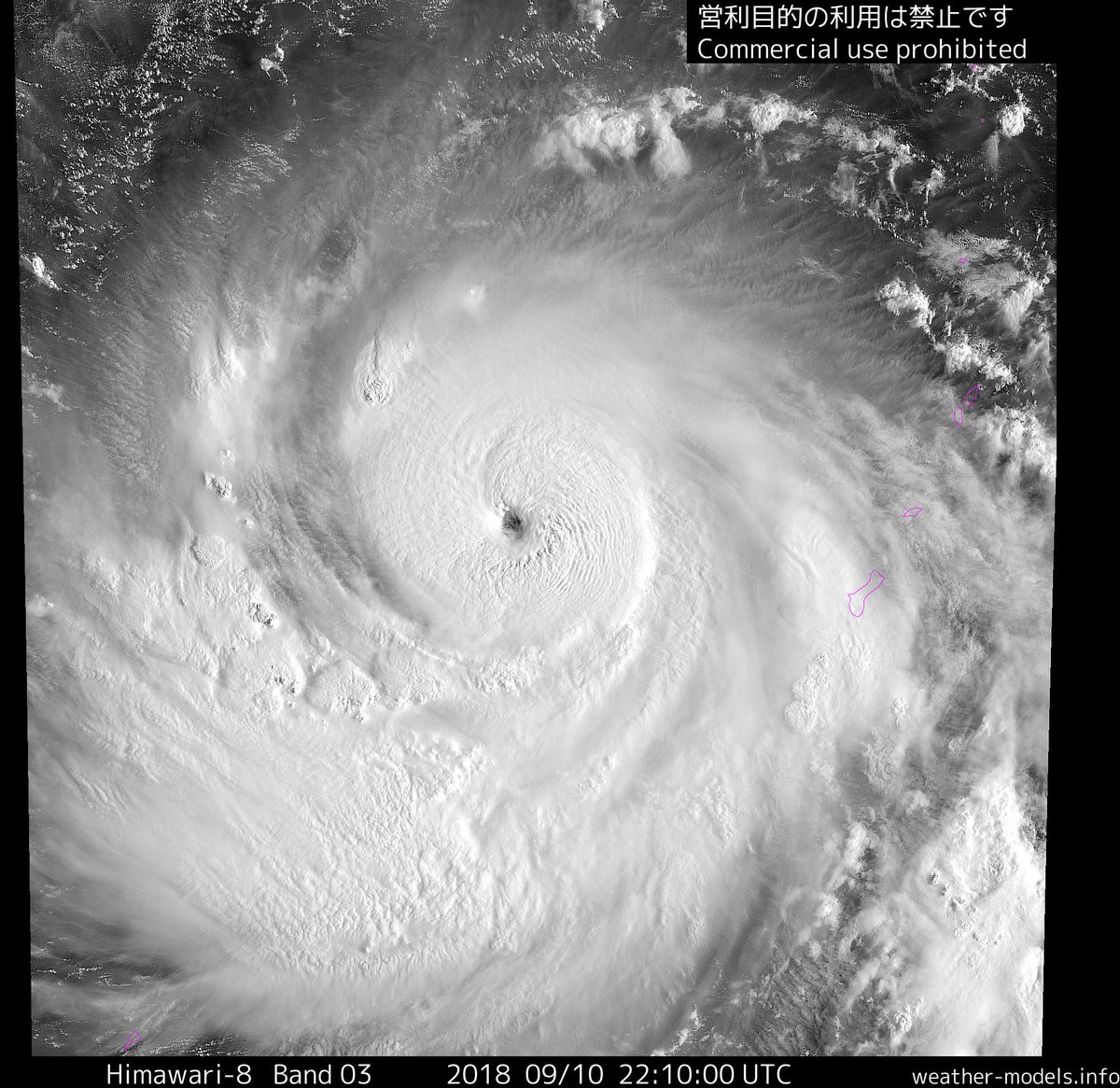
It's all relative. Relatively dry air gets wrapped up pretty regularly in these storms.

You can see the more stable air just south of the eye.

 Page 165 of 400

Popular
Back to top