- My Forums
- Tiger Rant
- LSU Recruiting
- SEC Rant
- Saints Talk
- Pelicans Talk
- More Sports Board
- Fantasy Sports
- Golf Board
- Soccer Board
- O-T Lounge
- Tech Board
- Home/Garden Board
- Outdoor Board
- Health/Fitness Board
- Movie/TV Board
- Book Board
- Music Board
- Political Talk
- Money Talk
- Fark Board
- Gaming Board
- Travel Board
- Food/Drink Board
- Ticket Exchange
- TD Help Board
Customize My Forums- View All Forums
- Show Left Links
- Topic Sort Options
- Trending Topics
- Recent Topics
- Active Topics
Started By
Message

 2
2


Posted on 8/25/17 at 2:32 pm to LSUBoo
Thank you 

Posted on 8/25/17 at 2:33 pm to slackster
quote:
156 hour Euro has 60" maximum rain accumulation.
Posted on 8/25/17 at 2:34 pm to dabigfella
quote:
It could literally be 7-10 days if not more.
Eta: will refrain from discussing here...
This post was edited on 8/25/17 at 2:35 pm
Posted on 8/25/17 at 2:34 pm to tke857
Anyone else see that car flooded in Corpus Christi on The Weather Channel just now??? This is only the beginning...unreal
Posted on 8/25/17 at 2:34 pm to dabigfella
Karma will take of you.

Posted on 8/25/17 at 2:34 pm to dabigfella
Not sure if posted already but the reddit livestream is up.
LINK

LINK
This post was edited on 8/25/17 at 2:37 pm

Posted on 8/25/17 at 2:35 pm to tke857
quote:
sub 940MB here we come.
Will that mean it strengthens or weakens?

Posted on 8/25/17 at 2:36 pm to emanresu
Looks like supernovasky is contributing to the live page.
This post was edited on 8/25/17 at 2:37 pm
Posted on 8/25/17 at 2:36 pm to dabigfella
quote:
take a few million dollars of your own money and go buy a store
Hmm. Didn't you inherit those stores?
Now back to the hurricane.
Posted on 8/25/17 at 2:37 pm to tke857
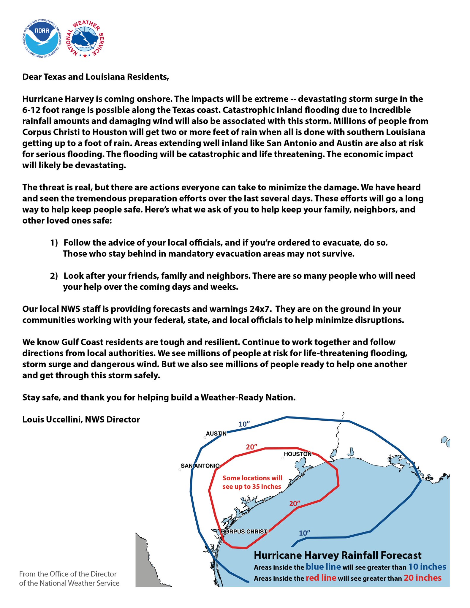
Well, that's the first time I remember an open letter from the NWS director before an emergency occurs.
Posted on 8/25/17 at 2:38 pm to Bunta
i saw that....wonder if its the same person....
ETA: yep gotta be same person

ETA: yep gotta be same person
This post was edited on 8/25/17 at 2:39 pm
Posted on 8/25/17 at 2:39 pm to Polar Pop
quote:
Will that mean it strengthens or weakens?
intensifying
Posted on 8/25/17 at 2:40 pm to Polar Pop
For reference, generally speaking sub 940 mb pressure is cat 4/ "weak" 5 neighborhood.

Posted on 8/25/17 at 2:41 pm to Polar Pop
quote:
Will that mean it strengthens or weakens?
Strengthens. Lower number the stronger.
Posted on 8/25/17 at 2:41 pm to rds dc
Historical flooding event getting under way. Everyone should pay close attention to their local NWS office and local officials.
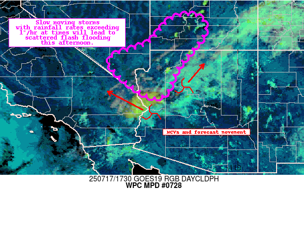
MESOSCALE PRECIPITATION DISCUSSION
0728 NWS WEATHER PREDICTION CENTER
COLLEGE PARK MD 242 PM EDT FRI AUG 25 2017
AREAS AFFECTED...UPPER TX COAST...SOUTHWEST LA COAST CONCERNING...HEAVY RAINFALL...
FLASH FLOODING POSSIBLE
VALID 251845Z - 260000Z SUMMARY...OUTER BANDS FROM HARVEY WILL CONTINUE TO CROSS PORTIONS OF SOUTHWEST LA INTO THE UPPER TX COAST. THE ADDITIONAL RAINFALL COULD POSE A CONTINUED FLASH FLOOD THREAT THROUGH THE AFTERNOON HOURS. DISCUSSION...THE GOES-16 CLEAN IR LOOP SHOWED OUTER BANDS FROM HURRICANE HARVEY CONTINUING TO MOVE NORTH TOWARD THE SOUTHWEST LA COAST AND THE UPPER COAST OF TX. TOPS HAVE BEEN ALTERNATELY WARMING AND COOLING...WITH THE COLDEST TOPS APPROACHING THE SOUTHWEST AND CENTRAL LA COAST. THE KLCH RADAR SHOWED HOURLY RAINFALL RATES BETWEEN 1.50 AND 2.00 INCHES WITH THE INITIAL OUTER BANDS...AND GIVEN THE TROPICAL AIRMASS IN PLACE (WITH THE MOST RECENT RAP SHOWING PRECIPITABLE WATER VALUES BETWEEN 2.25 AND 2.50 INCHES)... THESE HOURLY RAINFALL RATES ARE POSSIBLE ALONG THE LATE AFTERNOON HOURS. THE BEST INSTABILITY APPEARS TO LIE NEAR THE COAST (AND CLOSE TO THE FRONTAL BOUNDARY IN PLACE)...AND THE LOW LEVEL CONVERGENT FLOW IS FOCUSING THE INSTABILITY AND DEEP MOISTURE ALONG THE COAST. MOST OF THE HIGH RESOLUTION MODELS SUGGEST THAT THE UPPER TX COAST WILL SEE THE HIGHEST RAINFALL AMOUNTS ASSOCIATED WITH THE OUTER BANDS. THE MOST RECENT HRRR SHOWED LOCAL 5.00+ INCH AMOUNTS OVER THE UPPER TX COAST...AND GIVEN WHAT HAS ALREADY OCCURRED...THESE AMOUNTS SEEM PLAUSIBLE WHERE BANDS PERSIST OR TRAIN. THE ADDITIONAL RAINFALL COULD BE A FLASH FLOOD ISSUE IN PLACES LIKE PORT O'CONNOR... WHERE DAM ISSUES REMAIN. IN ADDITION... PORTIONS OF SOUTHWEST LA HAVE RECEIVED THEIR ANNUAL RAINFALL...AND MAY ALSO BE SENSITIVE TO THE ADDITIONAL HEAVY RAINFALL. HAYES

Posted on 8/25/17 at 2:41 pm to NYNolaguy1
quote:
For reference, generally speaking sub 940 mb pressure is cat 4/ "weak" 5 neighborhood.
Posted on 8/25/17 at 2:42 pm to NYNolaguy1
quote:
For reference, generally speaking sub 940 mb pressure is cat 4/ "weak" 5 neighborhood.
winds would have to catch up to get there
Posted on 8/25/17 at 2:43 pm to rt3

Posted on 8/25/17 at 2:43 pm to Walt OReilly
quote:
THIs thread could go down as the longest thread in TD history
You think the REC is driving this to Aggieland?
Stay safe Tejanos.
This post was edited on 8/25/17 at 2:45 pm

 Page 211 of 618

Popular
Back to top