- My Forums
- Tiger Rant
- LSU Recruiting
- SEC Rant
- Saints Talk
- Pelicans Talk
- More Sports Board
- Fantasy Sports
- Golf Board
- Soccer Board
- O-T Lounge
- Tech Board
- Home/Garden Board
- Outdoor Board
- Health/Fitness Board
- Movie/TV Board
- Book Board
- Music Board
- Political Talk
- Money Talk
- Fark Board
- Gaming Board
- Travel Board
- Food/Drink Board
- Ticket Exchange
- TD Help Board
Customize My Forums- View All Forums
- Show Left Links
- Topic Sort Options
- Trending Topics
- Recent Topics
- Active Topics
Started By
Message
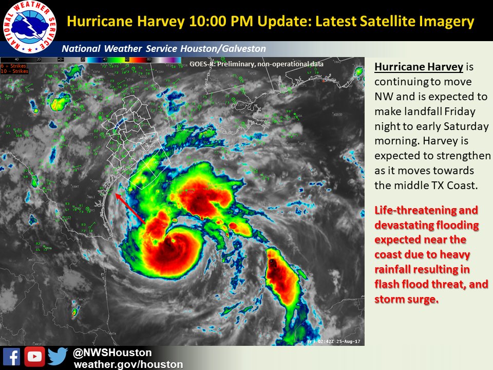
re: Harvey ***Catastrophic Flooding Event***
Posted on 8/24/17 at 10:25 pm to slackster
Posted on 8/24/17 at 10:25 pm to slackster
quote:
Looks like Harvey may be pulling in that NW "blob" of convection. If that materializes, it may resume the intensification at a more rapid pace.
Yea, you can see cloud tops warming out there and the eastern eyewall has started to cool. The pause certainly appears to be over, probably assisted by the very intense eyewall convection we saw on the NW side earlier this evening.
This post was edited on 8/24/17 at 10:27 pm
 1
1

Posted on 8/24/17 at 10:26 pm to Roll Tide Ravens
quote:
Hurricane Hunters have found a 966mb pressure.
The VDM came in at 972mb.
Posted on 8/24/17 at 10:27 pm to Roll Tide Ravens
quote:
Hurricane Hunters have found a 966mb pressure.

Posted on 8/24/17 at 10:28 pm to Roll Tide Ravens
dp
This post was edited on 8/24/17 at 10:29 pm
Posted on 8/24/17 at 10:28 pm to NorthEndZone
David Bernard just reported that hes following the hurricane hunters in real time and the eye is now well formed, pressure dropped and appears to have moved due north.
This is not looking good
This is not looking good
This post was edited on 8/24/17 at 10:31 pm

Posted on 8/24/17 at 10:28 pm to ell_13
Should be a Cat. 2 at the next advisory.

Posted on 8/24/17 at 10:30 pm to tgrbaitn08
quote:
appears to have moved due north.
Say what?
Posted on 8/24/17 at 10:30 pm to rds dc
Everyone is missing the only point that matters. How is this storm racist and/or Trumps fault? I NEED to know!
ETA: I know some really good people from Cameron. They all stuck with it past Rita. Half of them stuck with it past Ike. But I can't see any of them sticking with it again if God forbid it happens again.
ETA: I know some really good people from Cameron. They all stuck with it past Rita. Half of them stuck with it past Ike. But I can't see any of them sticking with it again if God forbid it happens again.
This post was edited on 8/24/17 at 10:37 pm
Posted on 8/24/17 at 10:30 pm to tgrbaitn08
I don't trust anyone with two first names.

Posted on 8/24/17 at 10:31 pm to tgrbaitn08
quote:
nd appears to have moved due north. This is not looking good
Watch your mouth.
I remember Rita doing this and I went to bed one night and woke up and she took a die north turn. Had to get out that same day.
Posted on 8/24/17 at 10:31 pm to stout
Lol no it's not. Are you out of your mind??
Posted on 8/24/17 at 10:31 pm to tgrbaitn08
quote:
David Bernard just reported that hes following the hurricane hunters in real time and the eye is now well formed, pressure dropped and appears to have moved due north.
Being in Lafayette, this scares me.
Posted on 8/24/17 at 10:32 pm to rds dc
Product: Air Force Vortex Message (URNT12 KNHC)
Transmitted: 25th day of the month at 3:21Z
Agency: United States Air Force
Aircraft: Lockheed WC-130J Hercules with reg. number AF98-5307
Storm Number & Year: 09 in 2017
Storm Name: Harvey (flight in the North Atlantic basin)
Mission Number: 15
Observation Number: 16
A. Time of Center Fix: 25th day of the month at 2:52:00Z
B. Center Fix Coordinates: 25°12'N 94°41'W (25.2N 94.6833W)
B. Center Fix Location: 182 statute miles (293 km) to the ESE (106°) from Brownsville, TX, USA.
C. Minimum Height at Standard Level: 2,841m (9,321ft) at 700mb
D. Estimated (by SFMR or visually) Maximum Surface Wind Inbound: 68kts (~ 78.3mph)
E. Location of the Estimated Maximum Surface Wind Inbound: 9 nautical miles (10 statute miles) to the SW (215°) of center fix
F. Maximum Flight Level Wind Inbound: From 311° at 71kts (From the NW at ~ 81.7mph)
G. Location of Maximum Flight Level Wind Inbound: 7 nautical miles (8 statute miles) to the SSW (213°) of center fix
H. Minimum Sea Level Pressure: 972mb (28.71 inHg)
I. Maximum Flight Level Temp & Pressure Altitude Outside Eye: 12°C (54°F) at a pressure alt. of 3,062m (10,046ft)
J. Maximum Flight Level Temp & Pressure Altitude Inside Eye: 19°C (66°F) at a pressure alt. of 3,042m (9,980ft)
K. Dewpoint Temp (collected at same location as temp inside eye): 11°C (52°F)
K. Sea Surface Temp (collected at same location as temp inside eye): Not Available
L. Eye Character: Closed
M. Eye Shape & Diameter: Circular with a diameter of 10 nautical miles (12 statute miles)
N. Fix Determined By: Penetration, Radar, Wind, Pressure and Temperature
N. Fix Level: 700mb
O. Navigational Fix Accuracy: 0.02 nautical miles
O. Meteorological Accuracy: 3 nautical miles
Remarks Section:
Maximum Flight Level Wind: 79kts (~ 90.9mph) which was observed 27 nautical miles (31 statute miles) to the SE (125°) from the flight level center at 1:10:30Z
Maximum Flight Level Wind Outbound: 78kts (~ 89.8mph) which was observed 10 nautical miles (12 statute miles) to the WNW (300°) from the flight level center at 2:54:50Z
Dropsonde Surface Wind at Center: From 30° at 17kts (From the NNE at 20mph)
Posted on 8/24/17 at 10:32 pm to Loungefly85
quote:
Everyone is missing the only point that matters. How is this storm racist and/or Trumps fault? I NEED to know!
Because he called it a girl and it's name is Harvey lol.
Posted on 8/24/17 at 10:32 pm to TDsngumbo
quote:
uote:
appears to have moved due north.
Say what?
He's looking at where they are flying compared to the last reported location.

Posted on 8/24/17 at 10:33 pm to tgrbaitn08
Posted on 8/24/17 at 10:34 pm to Cajunese
As it looks like it's ramping up, it's going to wobble around. It's moved NW with steps N and W over the past six hours. It should continue to
Posted on 8/24/17 at 10:35 pm to tgrbaitn08
quote:
David Bernard just reported that hes following the hurricane hunters in real time and the eye is now well formed, pressure dropped and appears to have moved due north.
This is not looking good
I absolutely respect David Bernard for his time at WWL-TV
hopefully that north move is a wobble and not something consistent
Posted on 8/24/17 at 10:36 pm to rds dc
00z GFS is showing landfall at 948 mb

 Page 142 of 618

Popular
Back to top