- My Forums
- Tiger Rant
- LSU Recruiting
- SEC Rant
- Saints Talk
- Pelicans Talk
- More Sports Board
- Coaching Changes
- Fantasy Sports
- Golf Board
- Soccer Board
- O-T Lounge
- Tech Board
- Home/Garden Board
- Outdoor Board
- Health/Fitness Board
- Movie/TV Board
- Book Board
- Music Board
- Political Talk
- Money Talk
- Fark Board
- Gaming Board
- Travel Board
- Food/Drink Board
- Ticket Exchange
- TD Help Board
Customize My Forums- View All Forums
- Show Left Links
- Topic Sort Options
- Trending Topics
- Recent Topics
- Active Topics
Started By
Message
re: Friday weather thread. Tornado watches everywhere, warnings, too
Posted on 3/31/23 at 10:09 pm to Bobby OG Johnson
Posted on 3/31/23 at 10:09 pm to Bobby OG Johnson
quote:
Apparently Reed & someone was playing bumper cars today
View from Reed's car
There is a segment of the chasing community who are complete and total fricking idiots. Reed isn't one of those, especially when driving.
 1
1

Posted on 3/31/23 at 10:10 pm to East Coast Band
Ok which every one of you mfers took the sacred idol, skull, whatever it was you never should have touch put the mfer back
Posted on 3/31/23 at 10:10 pm to JCinBAMA
quote:
Damn no sleep for me tonight
Hell, go to sleep now and you could get a few hours at the rate this thing is going.
Posted on 3/31/23 at 10:10 pm to LegendInMyMind
Spencer, IL confirmed heading toward Martinsville. Decent sized towns.
quote:
At 1104 PM EDT, a confirmed tornado was located near Spencer, or 12
miles northwest of Bloomington, moving east at 65 mph.
HAZARD...Damaging tornado.
SOURCE...Radar confirmed tornado.
IMPACT...Flying debris will be dangerous to those caught without
shelter. Mobile homes will be damaged or destroyed. Damage
to roofs, windows, and vehicles will occur. Tree damage is
likely.
This tornado will be near...
Paragon around 1110 PM EDT.
Martinsville and Mahalasville around 1120 PM EDT.
Other locations in the path of this tornadic thunderstorm include
Morgantown.

Posted on 3/31/23 at 10:11 pm to Bobby OG Johnson
Strong evidence of a tornado passing near Owensboro, KY.
Posted on 3/31/23 at 10:13 pm to Roll Tide Ravens

Posted on 3/31/23 at 10:13 pm to NorthEndZone
Our long tracker in TN is officially in a radar hole.
Paging Wishn to bitch about this one for me.
Paging Wishn to bitch about this one for me.

Posted on 3/31/23 at 10:14 pm to Roll Tide Ravens
Those tornados almost always follow right down the Ohio too.
Posted on 3/31/23 at 10:14 pm to Wishnitwas1998
quote:
I'm afraid the cells are gonna get over northern ms aka Oxford area and go fricking crazy given it's completely untapped
This huge yellow and red dick shaped system appears to run right with highway 6 right into Oxford
Ugh. Just let it be rain and thunder and lightning

Posted on 3/31/23 at 10:16 pm to LegendInMyMind
quote:
There is a segment of the chasing community who are complete and total fricking idiots. Reed isn't one of those, especially when driving.
It was the tranny chaser
Made the excuse of Reed slamming on the brakes so had to pass on the right which is a lie
Posted on 3/31/23 at 10:19 pm to Bobby OG Johnson
quote:
It was the tranny chaser
Nevermind. Different one.
This post was edited on 3/31/23 at 10:23 pm
Posted on 3/31/23 at 10:19 pm to LegendInMyMind
Lot of cells about to move into north ms
Posted on 3/31/23 at 10:21 pm to LegendInMyMind
quote:
Our long tracker in TN is officially in a radar hole. Paging Wishn to bitch about this one for me.
Many sads : (
I actually had friends that live out that way asking me what it was gonna do. They of course have no idea what a "radar hole" is. It was quite the challenge to explain to them that IDK WTF ITS GOING TO DO BC THE RADAR IS USELESS in a calm fashion
Posted on 3/31/23 at 10:22 pm to Lawyered
Annnndddddddddddd there's the first warning in thay round of storm
Son of a bitch
Son of a bitch
Posted on 3/31/23 at 10:23 pm to Wishnitwas1998
Here's to hoping it struggles.
Posted on 3/31/23 at 10:25 pm to LegendInMyMind
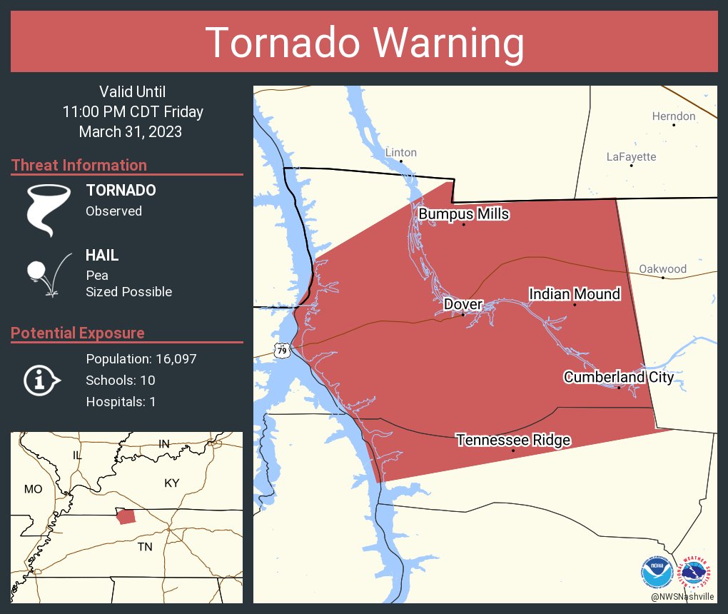
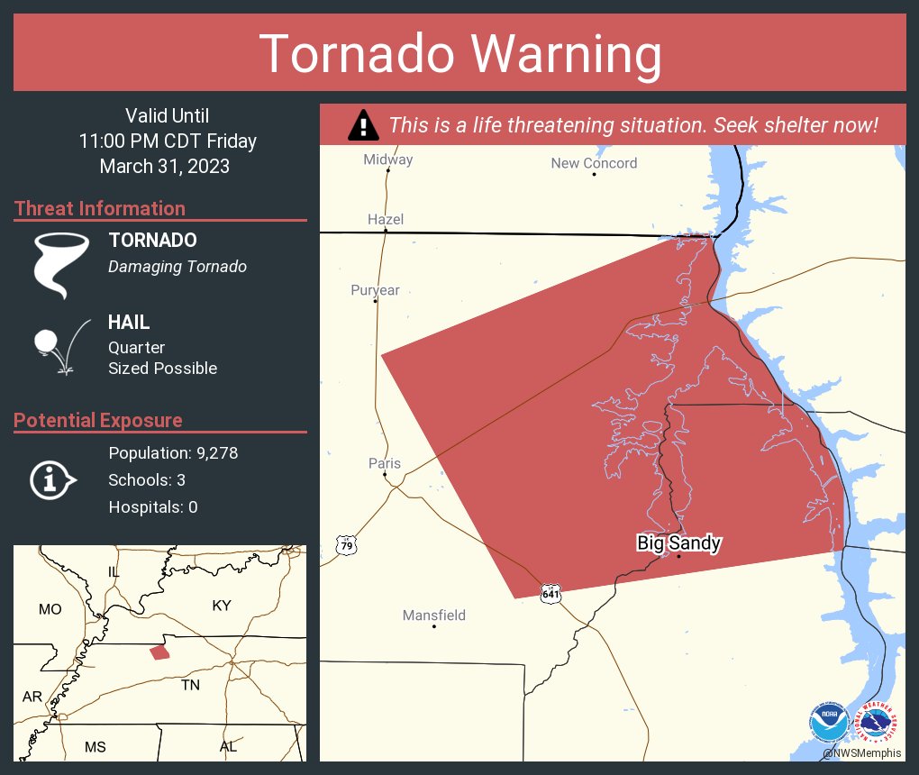
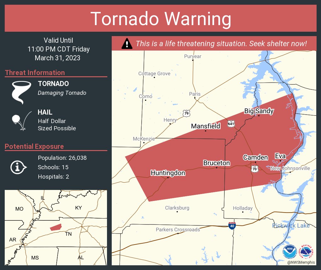
That looks bad in Paris, TN
Posted on 3/31/23 at 10:26 pm to Wishnitwas1998

Posted on 3/31/23 at 10:26 pm to LegendInMyMind
I’m going to try to get a few winks in but I usually can’t.
Posted on 3/31/23 at 10:29 pm to Bobby OG Johnson
Posted on 3/31/23 at 10:30 pm to Bobby OG Johnson

 Page 40 of 48

Popular
Back to top