- My Forums
- Tiger Rant
- LSU Recruiting
- SEC Rant
- Saints Talk
- Pelicans Talk
- More Sports Board
- Fantasy Sports
- Golf Board
- Soccer Board
- O-T Lounge
- Tech Board
- Home/Garden Board
- Outdoor Board
- Health/Fitness Board
- Movie/TV Board
- Book Board
- Music Board
- Political Talk
- Money Talk
- Fark Board
- Gaming Board
- Travel Board
- Food/Drink Board
- Ticket Exchange
- TD Help Board
Customize My Forums- View All Forums
- Show Left Links
- Topic Sort Options
- Trending Topics
- Recent Topics
- Active Topics
Started By
Message
re: Delta Moves On...Cleanup Begins
Posted on 10/9/20 at 6:58 am to DeathValley1924

Posted on 10/9/20 at 6:58 am to DeathValley1924
Looks like welsh, jennings, iota, gueydan gonna get the worst of this one.
 2
2

Posted on 10/9/20 at 6:58 am to rds dc


Posted on 10/9/20 at 6:59 am to slackster
Plus they’ve already got double their predicted rainfall. Yay Peej.
This post was edited on 10/9/20 at 6:59 am
Posted on 10/9/20 at 6:59 am to BPTiger
NHC dragging arse on 7am update
Posted on 10/9/20 at 7:00 am to DeathValley1924
What are the estimated sustained winds after the 4AM advisory?

Posted on 10/9/20 at 7:00 am to BPTiger

Posted on 10/9/20 at 7:00 am to VermilionTiger
LOCATION...27.5N 93.8W
ABOUT 160 MI...255 KM S OF CAMERON LOUISIANA
MAXIMUM SUSTAINED WINDS...120 MPH...195 KM/H
PRESENT MOVEMENT...N OR 350 DEGREES AT 12 MPH...19 KM/H
MINIMUM CENTRAL PRESSURE...958 MB...28.29 INCHES
Still moving just west of north
Would like to see a continued drop in strength on 10 AM
ABOUT 160 MI...255 KM S OF CAMERON LOUISIANA
MAXIMUM SUSTAINED WINDS...120 MPH...195 KM/H
PRESENT MOVEMENT...N OR 350 DEGREES AT 12 MPH...19 KM/H
MINIMUM CENTRAL PRESSURE...958 MB...28.29 INCHES
Still moving just west of north
Would like to see a continued drop in strength on 10 AM
This post was edited on 10/9/20 at 7:02 am
Posted on 10/9/20 at 7:00 am to VermilionTiger
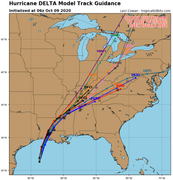
Read the graphic on the first page
Posted on 10/9/20 at 7:01 am to Dire Wolf
Center at 93.8. Still not turning toward NNE - yet.
Pressure at 958 millibars
Pressure at 958 millibars
This post was edited on 10/9/20 at 7:02 am
Posted on 10/9/20 at 7:02 am to rds dc
South Toledo Bend, breezy, hazy with light drizzle. Looking forward to hearing my generators run non stop for the next few days. frick a damn hurricane!

Posted on 10/9/20 at 7:03 am to NorthEndZone
Heading dude north now though...
Posted on 10/9/20 at 7:03 am to Cosmo
So we’re thinking a Grand Lake/White Lake landfall now?
Posted on 10/9/20 at 7:04 am to PhillyTiger90
Between grand chenier and grand lake i believe
Posted on 10/9/20 at 7:04 am to pistolpete23
Latest GFS run is initializing way too weak. Has it at 970mb at this point and the actual storm is still 953.
I would pay attention to HWRF and HMON for accurate intensity at landfall as both initialized in the 950s. Both have it low 960s at landfall which will be high end Cat 2 most likely.
I would pay attention to HWRF and HMON for accurate intensity at landfall as both initialized in the 950s. Both have it low 960s at landfall which will be high end Cat 2 most likely.
Posted on 10/9/20 at 7:04 am to Impotent Waffle
Center is clearly present on the Houston radar, so wobble watching can commence in earnest for those in SWLA.
Posted on 10/9/20 at 7:07 am to NorthEndZone
Never thought it would get past 93.7. The fact that it is moving at 350 degrees is also a built perplexing. Based on the 7p last night I thought this thing would turn East a hair earlier than it is.
Posted on 10/9/20 at 7:08 am to slackster
(no message)
This post was edited on 3/31/23 at 4:18 pm
Posted on 10/9/20 at 7:08 am to slackster
 [/url][/img]
Posted on 10/9/20 at 7:08 am to slackster
Is this thing getting kicked farther East than projected?
Posted on 10/9/20 at 7:10 am to Tigeralum2008
93.8 W position is due south of sabine pass.
Need to get that NNE movement by 10 AM update to stay centered in cone
Need to get that NNE movement by 10 AM update to stay centered in cone
This post was edited on 10/9/20 at 7:11 am

 Page 416 of 601

Popular
Back to top