- My Forums
- Tiger Rant
- LSU Recruiting
- SEC Rant
- Saints Talk
- Pelicans Talk
- More Sports Board
- Fantasy Sports
- Golf Board
- Soccer Board
- O-T Lounge
- Tech Board
- Home/Garden Board
- Outdoor Board
- Health/Fitness Board
- Movie/TV Board
- Book Board
- Music Board
- Political Talk
- Money Talk
- Fark Board
- Gaming Board
- Travel Board
- Food/Drink Board
- Ticket Exchange
- TD Help Board
Customize My Forums- View All Forums
- Show Left Links
- Topic Sort Options
- Trending Topics
- Recent Topics
- Active Topics
Started By
Message

 0
0


Posted on 10/8/20 at 9:51 am to TigersGeaux001
quote:
have a flight scheduled from MSY to Tampa tomorrow morning at 7:50 what are the chances that gets canceled
Highly unlikely

Posted on 10/8/20 at 9:51 am to TigersGeaux001
Driving from Tampa to Punta Cana?
Posted on 10/8/20 at 9:51 am to junkfunky
quote:
First point of failure is almost always roof lifting off the house.
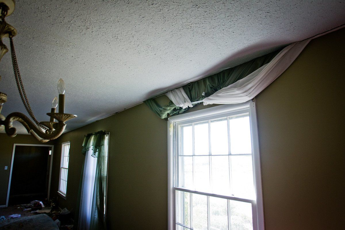
I saw a pic from the Smithville, MS tornado from April 27, 2011 that made me a believer in hurricane construction even away from the coast. The pic was in a living room. The curtains on a window had been literally sucked upward and pulled through the corner where the wall meets the roof/ceiling. 95% of the curtain was flapping in the wind outside of the house. The roof was still on and the wall was still upright, just like normal. The house itself was still structurally intact. It had some roof damage and some debris knocked holes in walls.
This post was edited on 10/8/20 at 9:52 am
Posted on 10/8/20 at 9:52 am to SW2SCLA
quote:
I have a flight out of Beaumont
Thats something you dont hear everyday

Posted on 10/8/20 at 9:52 am to Impotent Waffle
Highly unlikely it gets canceled or highly unlikely it flies?

Posted on 10/8/20 at 9:52 am to tgrbaitn08
Fly out of Beaumont for your connecting flight at IAH
Posted on 10/8/20 at 9:53 am to fightin tigers
N/M
This post was edited on 10/8/20 at 9:54 am
Posted on 10/8/20 at 9:53 am to JonTheTigerFan

Posted on 10/8/20 at 9:53 am to LegendInMyMind
Metal buildings like warehouses and school gyms are the craziest. A corner will lift and internal pressure starts blowing windows and doors out like a bomb went off.
This post was edited on 10/8/20 at 9:55 am
Posted on 10/8/20 at 9:53 am to Cosmo
quote:
Fly out of Beaumont for your connecting flight at IAH

Posted on 10/8/20 at 9:55 am to TigersGeaux001
quote:
I have a quick question for any of you weather and or aviation guys. I have a flight scheduled from MSY to Tampa tomorrow morning at 7:50 what are the chances that gets canceled?
Somewhere around eleventeen percent if my math is correct.
This post was edited on 10/8/20 at 9:56 am
Posted on 10/8/20 at 9:55 am to tgrbaitn08
I’d like to make a suggestion for this thread and all hurricane threads moving forward. We need more Stephanie abrams in between advisories.
Posted on 10/8/20 at 9:55 am to LegendInMyMind
I went and found the pic of the curtains from the Smithville, MS tornado:
Crazy.
Crazy.
Posted on 10/8/20 at 9:55 am to LSUWoodworker
quote:I hope not.
I titty milk still on the discussion list for today...?\
Posted on 10/8/20 at 9:56 am to LegendInMyMind
quote:
I've never seen is someone porn bomb a hurricane thread.
quote:
I seen me a mermaid once. I even seen me a shark eat an octopus. But I ain't never seen no phantom Russian submarine.
Posted on 10/8/20 at 9:56 am to tgrbaitn08
quote:
Hurricane Delta
...NOAA AND AIR FORCE RESERVE HURRICANE HUNTERS REPORT DELTA HAS STRENGTHENED... ...HURRICANE CONDITIONS AND LIFE-THREATENING STORM SURGE EXPECTED TO BEGIN ALONG PORTIONS OF THE NORTHERN GULF COAST ON FRIDAY...
10:00 AM CDT Thu Oct 8
Location: 24.0°N 92.7°W
Moving: NW at 14 mph
Min pressure: 968 mb
Max sustained: 105 mph
Posted on 10/8/20 at 9:56 am to LegendInMyMind
quote:
The initial motion remains northwestward or 305/12 kt. The track forecast is reasonably straightforward. During the next 12-24 h, Delta should turn to the north between a mid- to upper-level ridge over the Florida Peninsula and eastern Gulf of Mexico and a mid- to upper-level level trough over the U.S. Southern Plains. This should be followed by a north-northeastward motion that is expected to bring the center near or over the northern Gulf coast, most likely in southwestern Louisiana, in about 36 h. After landfall, the cyclone should move northeastward through the Lower Mississippi and Tennessee Valleys along the southern edge of the mid-latitude westerlies until it dissipates. The track guidance is very tightly clustered in terms of direction, and the new forecast track has only minor tweaks from the previous one.
We'll be the judge of that once we zoom in to Cameron Parish...
Posted on 10/8/20 at 9:57 am to TigersGeaux001
quote:
Highly unlikely it gets canceled or highly unlikely it flies?
Cancelled

 Page 320 of 601

Popular
Back to top