- My Forums
- Tiger Rant
- LSU Recruiting
- SEC Rant
- Saints Talk
- Pelicans Talk
- More Sports Board
- Fantasy Sports
- Golf Board
- Soccer Board
- O-T Lounge
- Tech Board
- Home/Garden Board
- Outdoor Board
- Health/Fitness Board
- Movie/TV Board
- Book Board
- Music Board
- Political Talk
- Money Talk
- Fark Board
- Gaming Board
- Travel Board
- Food/Drink Board
- Ticket Exchange
- TD Help Board
Customize My Forums- View All Forums
- Show Left Links
- Topic Sort Options
- Trending Topics
- Recent Topics
- Active Topics
Started By
Message

 0
0

Posted on 9/28/20 at 10:15 am to Cosmo
quote:
Lets play the 360 hour GFS game
You forgot the first system that spins up that is associated with the wave NHC is currently tracking.
Posted on 9/28/20 at 10:25 am to rds dc

Meh.
Can live with the lemon with this parking overhead for a week plus.
Posted on 9/28/20 at 10:42 am to Duke
quote:
Can live with the lemon with this parking overhead for a week plus.
I agree. Now, let's do something about the dicking with the clocks and we've got it made.
4:30 sunset coming soon......
Posted on 9/28/20 at 10:44 am to LegendInMyMind
quote:
4:30 sunset coming soon......
Posted on 9/28/20 at 10:44 am to Duke
quote:
Meh.
Can live with the lemon with this parking overhead for a week plus.
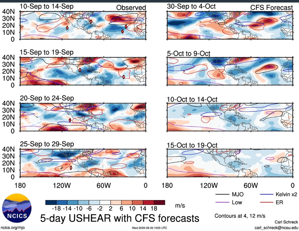
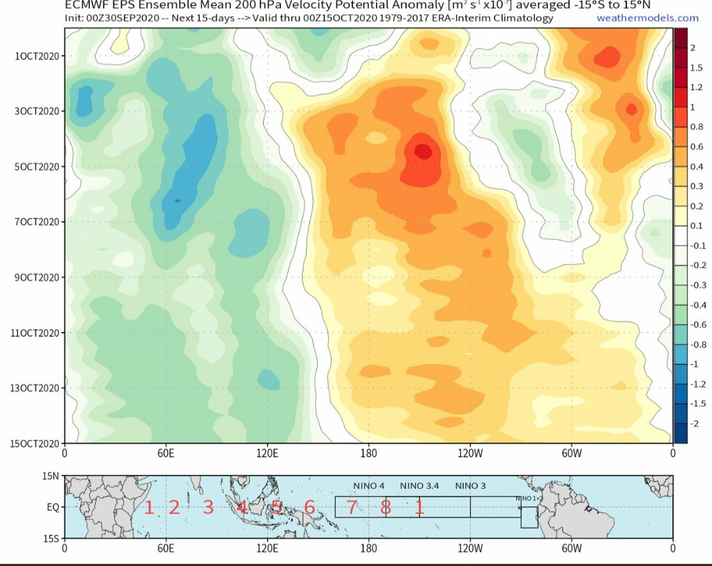
Anything that forms sooner heads off to the NE and is probably sheared. The problem is that the pattern stays favorable over the next few weeks and eventually that trough lifts out and is replaced by a ridge. You can see the split showing up in the ensembles, so as of today, models show a greater risk for a significant Gulf threat the further out in time you go. It's impossible to say if we see 1 system (area NHC currently tracking), multiple systems like the GFS or no systems.
Posted on 9/28/20 at 10:45 am to Jim Rockford
I hate the time change more than I hate AT&T.
Posted on 9/28/20 at 10:54 am to rds dc
quote:
The problem is that the pattern stays favorable over the next few weeks and eventually that trough lifts out and is replaced by a ridge. You can see the split showing up in the ensembles, so as of today, models show a greater risk for a significant Gulf threat the further out in time you go. It's impossible to say if we see 1 system (area NHC currently tracking), multiple systems like the GFS or no systems.
For sure, and I expect multiples in the longer run. Everything this year wants to spin, favorable conditions, and warm water. Wouldn't bet against it that's for sure.
First wave the NHC is tracking should get sheared and kicked Florida way if it forms up. Timing of course always a little in the air.
I'll leave the worrying about the next part of the game to you for the time being.
Posted on 9/28/20 at 10:39 pm to rds dc
How much money you think pharm companies made off the gulf coast this year during hurricane season for anxiety meds?
Posted on 9/29/20 at 12:15 pm to rds dc
What does WCAB stand for?
TIA
TIA
Posted on 9/29/20 at 12:17 pm to warlock1974
quote:
What does WCAB stand for?
Western Caribbean
Posted on 9/29/20 at 12:25 pm to LegendInMyMind
quote:
4:30 sunset coming soon
Better than 7 am sunrise.
Posted on 9/29/20 at 12:36 pm to Bestbank Tiger
quote:
4:30 sunset coming soon
quote:
Better than 7 am sunrise.
Sorry, you're wrong. But that's okay.

Posted on 9/29/20 at 12:42 pm to warlock1974
quote:
What does WCAB stand for?
white cops are bastards
Posted on 9/30/20 at 11:02 am to rds dc
@philklotzbach
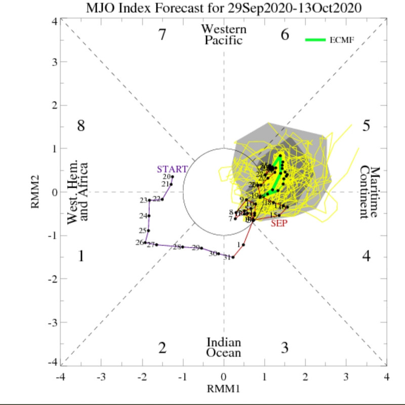
All that to say, don't sleep on the next few weeks. The overall setup is favorable for development.
quote:
CSU calls for above-normal Atlantic #hurricane activity w/ next 2-week forecast (9/30-10/13). Large-scale atmospheric conditions generally favor tropical cyclone activity over the Atlantic basin, with reduced wind shear anticipated:
All that to say, don't sleep on the next few weeks. The overall setup is favorable for development.
Posted on 9/30/20 at 11:03 am to LegendInMyMind
checking in from CenLA again
current conditions... sunny & 67 degrees at 11 AM

current conditions... sunny & 67 degrees at 11 AM
Posted on 9/30/20 at 11:06 am to rt3
quote:
current conditions... sunny & 67 degrees at 11 AM
In north AL, I traded in my sandals for house shoes and socks this AM. I always love the first day that happens.

Posted on 9/30/20 at 12:19 pm to LegendInMyMind
Bump
Posted on 9/30/20 at 8:01 pm to jimbeam
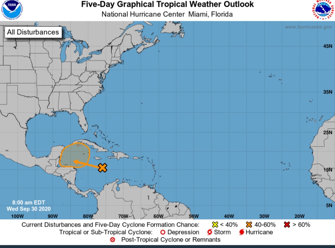
4 areas In Atlantic to watch now
Posted on 9/30/20 at 9:13 pm to rds dc
quote:
Models are in pretty good agreement that we will see a system develop in the WCAB during the 1st part of October. The waves that may produce this system are already tracking across the Atlantic, so that increases confidence in storm formation as they move into the WCAB over the next 7 - 10 days
The potential outcome is no clearer than it was a week ago but anything from no storms to 18z GFS-para could happen


 Page 3 of 601

Popular
Back to top