- My Forums
- Tiger Rant
- LSU Recruiting
- SEC Rant
- Saints Talk
- Pelicans Talk
- More Sports Board
- Fantasy Sports
- Golf Board
- Soccer Board
- O-T Lounge
- Tech Board
- Home/Garden Board
- Outdoor Board
- Health/Fitness Board
- Movie/TV Board
- Book Board
- Music Board
- Political Talk
- Money Talk
- Fark Board
- Gaming Board
- Travel Board
- Food/Drink Board
- Ticket Exchange
- TD Help Board
Customize My Forums- View All Forums
- Show Left Links
- Topic Sort Options
- Trending Topics
- Recent Topics
- Active Topics
Started By
Message
re: Beryl Thread - the clean up begins...
Posted on 6/30/24 at 10:02 am to Roll Tide Ravens
Posted on 6/30/24 at 10:02 am to Roll Tide Ravens
This is a bad bitch isn't it?
 2
2


Posted on 6/30/24 at 10:06 am to Bobby OG Johnson
Posted on 6/30/24 at 10:06 am to TDTOM
What is projected after it crosses the Yucatan?
This post was edited on 7/7/24 at 7:19 am
Posted on 6/30/24 at 10:07 am to Cosmo
quote:
quote:
All eyes are on the Euro model now. Both GFS and Canadian have come in between Victoria Tx and Morgan City.
Stressing about every model 10 days out is silly
The major players will be in place in a few days.
Watch the ridge (high pressure) over the SE US and the short wave trough (low pressure) moving across the Northern Plains. If the ridge trends weaker or slides off to the east faster, and the trough is faster or stronger, then Beryl will be able to turn NW faster, esp. if it's a strong hurricane in the WCAB. If the opposite happens, then Beryl will take more of western track into the BOC.

Posted on 6/30/24 at 10:09 am to Cosmo
quote:
Stressing about every model 10 days out is silly
Nobody is forecasting anything right now this far out. All models were going into Mexico 2 days ago and now some are trending a more northern turn.This morning more meteorologist are now mentioning a Texas landfall is in the table but not as a hurricane

Posted on 6/30/24 at 10:09 am to TDTOM
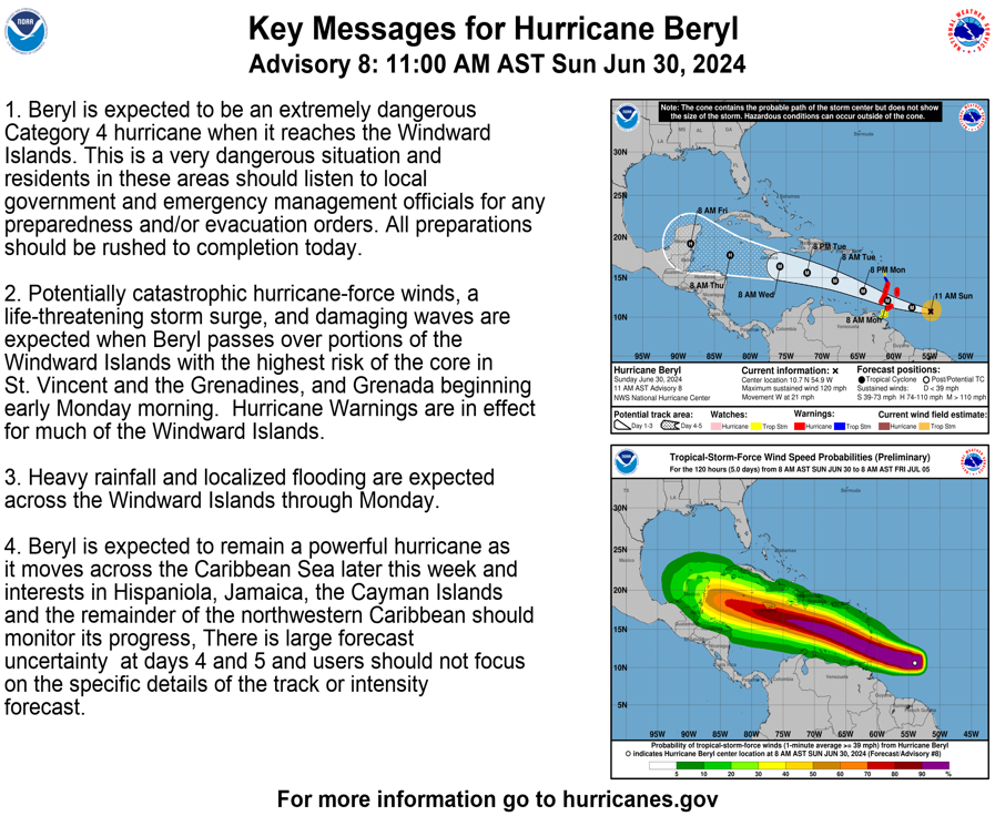
Yep, unfortunately. Grenada and Saint Vincent & the Grenadines are in a bad spot. People there are either going to need leave quickly or find higher ground.
Posted on 6/30/24 at 10:11 am to Roll Tide Ravens
Posted on 6/30/24 at 10:12 am to rds dc
quote:
What is projected after it crosses the Yucatan? Seems like it would run right into central Mexico
rds has a nice little explanation above.
quote:
Watch the ridge (high pressure) over the SE US and the short wave trough (low pressure) moving across the Northern Plains. If the ridge trends weaker or slides off to the east faster, and the trough is faster or stronger, then Beryl will be able to turn NW faster, esp. if it's a strong hurricane in the WCAB. If the opposite happens, then Beryl will take more of western track into the BOC.
This is a typical game with these systems. Ridge somewhere in the vicinity of the SE. Shortwave trough moving across the country from the northwest. That trough's strength and trajectory will influence the strength and position of the ridge. Stronger trough, weaker and farther east ridge. That's the scenario that opens a harder north turn and puts LA in potential danger.
Stronger storm, as rds notes, will want to go north quicker as well.
Posted on 6/30/24 at 10:12 am to Roll Tide Ravens

Posted on 6/30/24 at 10:26 am to rds dc
Will the HH data be in the 12z run or have to wait
Posted on 6/30/24 at 10:27 am to foosball
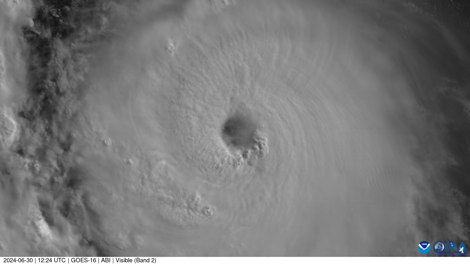
Just surreal images this morning as Beryl makes a run at Cat 5 today.
Loading Twitter/X Embed...
If tweet fails to load, click here.Posted on 6/30/24 at 10:29 am to purple18
Multiple Mets on twitter calling gulf coast landfall > 50%
Posted on 6/30/24 at 10:30 am to rds dc
quote:
Just surreal images this morning as Beryl makes a run at Cat 5 today.
Yep was just coming to post the gif
Posted on 6/30/24 at 10:31 am to Midtiger farm
Looking like Harvey/Laura track repeat
Posted on 6/30/24 at 10:31 am to foosball
The eye is really clearing out.


Posted on 6/30/24 at 10:33 am to Midtiger farm
quote:
Looking like Harvey/Laura track repeat
Way too early for that. There are always trends one way or another and so much time between now and any potential landfall.
Posted on 6/30/24 at 10:36 am to ApisMellifera
quote:
Way too early for that
No it isn’t - the storm is going to be strong enough to feel the weakness in the ridge.
Posted on 6/30/24 at 10:38 am to Bobby OG Johnson
Posted on 6/30/24 at 10:38 am to ApisMellifera
Pressure down to 960mb…looking like a Cat 4 already
Posted on 6/30/24 at 10:39 am to Midtiger farm
quote:
No it isn’t - the storm is going to be strong enough to feel the weakness in the ridge.
They have it as a Cat 1 going across Yucatan
Rapidly loses strength after going south of Cuba.

 Page 5 of 218

Popular
Back to top