- My Forums
- Tiger Rant
- LSU Recruiting
- SEC Rant
- Saints Talk
- Pelicans Talk
- More Sports Board
- Fantasy Sports
- Golf Board
- Soccer Board
- O-T Lounge
- Tech Board
- Home/Garden Board
- Outdoor Board
- Health/Fitness Board
- Movie/TV Board
- Book Board
- Music Board
- Political Talk
- Money Talk
- Fark Board
- Gaming Board
- Travel Board
- Food/Drink Board
- Ticket Exchange
- TD Help Board
Customize My Forums- View All Forums
- Show Left Links
- Topic Sort Options
- Trending Topics
- Recent Topics
- Active Topics
Started By
Message
re: Tropical Storm Isaias - O Canada!
Posted on 8/3/20 at 6:48 pm to Bobby OG Johnson
Posted on 8/3/20 at 6:48 pm to Bobby OG Johnson
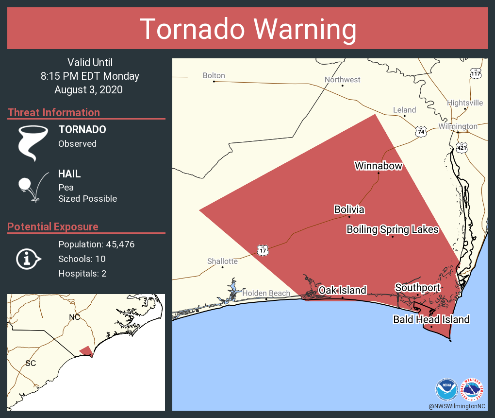
..ISAIAS REGAINS HURRICANE STRENGTH AND IS EXPECTED TO MAKE LANDFALL TONIGHT WITH DANGEROUS WINDS AND STORM SURGE... ...STRONG WINDS AND HEAVY RAINFALL LIKELY FROM THE EASTERN CAROLINAS TO THE MID-ATLANTIC COAST TONIGHT AND TUESDAY...
8:00 PM EDT Mon Aug 3
Location: 32.8°N 79.0°W
Moving: NNE at 16 mph
Min pressure: 988 mb
Max sustained: 75 mph
8:00 PM EDT Mon Aug 3
Location: 32.8°N 79.0°W
Moving: NNE at 16 mph
Min pressure: 988 mb
Max sustained: 75 mph
 1
1


Posted on 8/3/20 at 6:59 pm to lsuman25
quote:
ISAIAS REGAINS HURRICANE STRENGTH AND IS EXPECTED TO MAKE LANDFALL TONIGHT WITH DANGEROUS WINDS
NOAA, let’s settle down a little.

Posted on 8/3/20 at 7:07 pm to The Boat

This post was edited on 8/3/20 at 7:08 pm

Posted on 8/3/20 at 7:08 pm to The Boat
quote:
NOAA, let’s settle down a little.
100 million people at risk!
(I hate clickbait news.)
Posted on 8/3/20 at 7:15 pm to Bestbank Tiger
Wilmington NC here. Rain picking up. Some wind but nothing destructive. I still have power. Tornado warning for New Hanover County just came across my phone. 8:14 pm eastern.
Posted on 8/3/20 at 7:17 pm to Bobby OG Johnson
I see two tornadoes and another probable offshore.
Posted on 8/3/20 at 7:20 pm to Duke

Posted on 8/3/20 at 7:22 pm to Duke
Surge coming in at Myrtle Beach...9.25 is 3rd all-time
Posted on 8/3/20 at 7:24 pm to NorthEndZone
Recon dodged them both

Posted on 8/3/20 at 7:26 pm to Bobby OG Johnson
As that band rotates over I think you'll see a few tornados spin up. There's little weak rotations out over the water that'll likely drop to the ground as they get some frictional interaction with the ground.
Posted on 8/3/20 at 7:26 pm to NorthEndZone
Back side had stronger winds - at least at the buoy location
This post was edited on 8/3/20 at 7:28 pm
Posted on 8/3/20 at 7:29 pm to NorthEndZone

Posted on 8/3/20 at 7:38 pm to nchawg
Nvm i was slow.
I'm in Richlands nc and expected to drive to lejeune for work tomorrow @ 8. Prob gonna be too flooded on these roads.
I'm in Richlands nc and expected to drive to lejeune for work tomorrow @ 8. Prob gonna be too flooded on these roads.
This post was edited on 8/3/20 at 7:40 pm
Posted on 8/3/20 at 7:43 pm to Gusoline

Posted on 8/3/20 at 7:50 pm to NorthEndZone
Up to 9.27 now 3.25 above normal tide. Timing is bad - right at high tide.
Posted on 8/3/20 at 7:53 pm to NorthEndZone

Looks like they are finding some 100+ flight level winds.
Posted on 8/3/20 at 7:55 pm to lsuman25
And several SFMR 75 knot surface wind estimates
Posted on 8/3/20 at 7:57 pm to NorthEndZone
117 kt flight level. Wasn't expecting that.
Wilmington radar estimates agree with the plane obs too.
Wilmington radar estimates agree with the plane obs too.
This post was edited on 8/3/20 at 7:59 pm
Posted on 8/3/20 at 8:00 pm to Duke
Picking up a lil steam
Posted on 8/3/20 at 8:02 pm to Bobby OG Johnson
NHC bumps to 85 mph on that info. Unfortunately exceeding expectations.

 Page 45 of 50

Popular
Back to top