- My Forums
- Tiger Rant
- LSU Recruiting
- SEC Rant
- Saints Talk
- Pelicans Talk
- More Sports Board
- Fantasy Sports
- Golf Board
- Soccer Board
- O-T Lounge
- Tech Board
- Home/Garden Board
- Outdoor Board
- Health/Fitness Board
- Movie/TV Board
- Book Board
- Music Board
- Political Talk
- Money Talk
- Fark Board
- Gaming Board
- Travel Board
- Food/Drink Board
- Ticket Exchange
- TD Help Board
Customize My Forums- View All Forums
- Show Left Links
- Topic Sort Options
- Trending Topics
- Recent Topics
- Active Topics
Started By
Message
Hurricane Irma - Spinning Down
Posted on 8/30/17 at 2:02 pm
Posted on 8/30/17 at 2:02 pm

9.5.17 Cat 5

This post was edited on 9/12/17 at 7:26 am
 146
146

Posted on 8/30/17 at 2:03 pm to rds dc
(no message)
This post was edited on 9/8/17 at 8:00 pm

Posted on 8/30/17 at 2:04 pm to rds dc
I know a lot of people are tired of peej prediction meme but just to be safe, he needs to stay the frick out of this thread
Posted on 8/30/17 at 2:05 pm to rds dc
Euro is concerning, to say the least...

Still 10 days out, so take it with a grain of salt. Good news is it keeps the gulf low in the Bay of Campeche and appears to send it into Mexico at the end of the run.
ETA- 12z GFS run @ 240 hours:

Still 10 days out, so take it with a grain of salt. Good news is it keeps the gulf low in the Bay of Campeche and appears to send it into Mexico at the end of the run.
ETA- 12z GFS run @ 240 hours:
This post was edited on 8/30/17 at 2:07 pm

Posted on 8/30/17 at 2:06 pm to rds dc
"Irma" - classic old lady name. Scares me to death.
I'll use it in a sentence:
Irma shite myself if this storm gets into the gulf.
I'll use it in a sentence:
Irma shite myself if this storm gets into the gulf.

Posted on 8/30/17 at 2:06 pm to rds dc
I had an Aunt Irma. She was old, couldn't remember shite, and wore a red, curly wig. She died.

Posted on 8/30/17 at 2:21 pm to rds dc
(no message)
This post was edited on 9/7/17 at 9:56 pm
Posted on 8/30/17 at 2:31 pm to rds dc
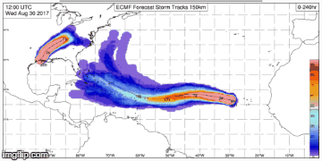
Based on the early model runs, the words "complex steering pattern" are going to be thrown around a lot in this thread.

Posted on 8/30/17 at 2:39 pm to rds dc
I know nothing is certain, but don't storms that form in this area typically curl north?
Posted on 8/30/17 at 2:53 pm to rds dc
The models are going to struggle with 93L. Wave breaking across the North Atlantic is going to spin off some ULLs, not to different than what we saw during 92Ls trip across the Atlantic. Then there is a massive WPAC system that is going to pump a ton of energy into the high latitudes and that always gives the models fits. As that energy is distributed to the downstream waves it will determine the large scale setup across America and the Atlantic as 93L approaches. Stronger Eastern trough and weaker Atlantic ridge closes doors to the Gulf. The reverse certainly causes concern.
Another issue, the outflow from any potential Gulf system could play a role. So, take any model solutions or speculation on what might happen based on model runs with a grain of salt.
However, climo tells us this system will have ample opportunities to curve out to sea.
Another issue, the outflow from any potential Gulf system could play a role. So, take any model solutions or speculation on what might happen based on model runs with a grain of salt.
However, climo tells us this system will have ample opportunities to curve out to sea.

Posted on 8/30/17 at 5:10 pm to rds dc
We need a cold front...
Posted on 8/30/17 at 5:53 pm to rds dc
18z GFS @ 240 hours

897mb would be the 5th strongest Atlantic storm on record. I don't expect a ton of accuracy this far out, but it is safe to say the models think conditions are favorable for development.
897mb would be the 5th strongest Atlantic storm on record. I don't expect a ton of accuracy this far out, but it is safe to say the models think conditions are favorable for development.
Posted on 8/30/17 at 10:16 pm to rds dc
This is starting to feel like an '04-'05 run 
Posted on 8/31/17 at 6:45 am to rds dc
Watch the SW turn, climo for storms that make that turn is a bit concerning. Last two Euro EPS runs:
This post was edited on 8/31/17 at 6:47 am

Posted on 8/31/17 at 8:23 am to rds dc
frick this euro

Posted on 8/31/17 at 4:10 pm to rds dc
Don't forget Matthew from last year, Euro and EPS were Gulf bound until they weren't. Euro is currently one of the farthest west models.
Posted on 8/31/17 at 7:26 pm to rds dc
Bit of a westward shift on the 18z GEFS, now has a member into Florida.


Posted on 8/31/17 at 7:59 pm to rds dc
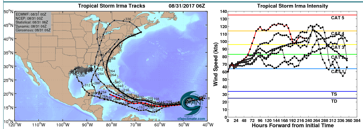
Found this nugget from earlier today by Dr. Jeff Masters on WunderGround:
quote:
quote:
To get a better sense of where Irma might go, it is often helpful to look at the ensemble forecasts from the European and GFS models. These forecasts take the operational high-resolution version of the models and impose slight variations in the initial atmospheric conditions, to simulate an ensemble of potential outcomes. They are run at lower resolution, so individual ensemble members are likely to be less reliable than the operational version. The GFS model runs 20 different ensemble forecasts, and the European model runs 50. One tool that I have found valuable is to look at the “high probability cluster” of the European model—the four ensemble members that have done the best job tracking Irma over the past day. Looking at Figure 2, the high probability cluster predicts that the Caribbean and U.S. Gulf Coast might be the most at-risk areas for a landfall by Irma.
Posted on 8/31/17 at 8:08 pm to rds dc
When we are all evacuating in 9 or 10 days, just remember it all started on page 15 at 7:34 pm on August 31st.

Posted on 8/31/17 at 9:40 pm to rds dc
Holy frick, this thing already has an eye being that far out?

 Page 1 of 8

Popular
Back to top