- My Forums
- Tiger Rant
- LSU Recruiting
- SEC Rant
- Saints Talk
- Pelicans Talk
- More Sports Board
- Fantasy Sports
- Golf Board
- Soccer Board
- O-T Lounge
- Tech Board
- Home/Garden Board
- Outdoor Board
- Health/Fitness Board
- Movie/TV Board
- Book Board
- Music Board
- Political Talk
- Money Talk
- Fark Board
- Gaming Board
- Travel Board
- Food/Drink Board
- Ticket Exchange
- TD Help Board
Customize My Forums- View All Forums
- Show Left Links
- Topic Sort Options
- Trending Topics
- Recent Topics
- Active Topics
Started By
Message

Southeast Severe Weather: 12/28 - 12/29
Posted on 12/28/24 at 6:24 am

Posted on 12/28/24 at 6:24 am
Outlook for 12/29:


Current Regional Radar:

Current Regional Radar:
This post was edited on 12/29/24 at 12:04 am
 22
22

Posted on 12/28/24 at 6:29 am to Roll Tide Ravens
Already a healthy cell northwesst of Baton Rouge near New Roads, tons of lightning

Posted on 12/28/24 at 6:36 am to Roll Tide Ravens
Should be an update to the SPC Day 1 in about 25 minutes. Waiting for it eagerly. Radar shows the storm more disorganized.
Posted on 12/28/24 at 6:49 am to Roll Tide Ravens
It's going to be a long day in central MS.
Posted on 12/28/24 at 6:54 am to Twincam
Posted on 12/28/24 at 6:58 am to Roll Tide Ravens
The weather outside is…. Weather.
Posted on 12/28/24 at 7:00 am to BabyTac
How do yall think this day pans out?
Posted on 12/28/24 at 7:00 am to Roll Tide Ravens
Posted on 12/28/24 at 7:01 am to lsuman25
Any sustained, discrete supercell in this environment will pose a
threat for cyclic, strong tornado production. As the primary
convective band organizes and moves into increasing moisture and
LLJ-enlarged hodographs in low levels this evening, embedded
LEWP/bowing features may produce both severe gusts and tornadoes.
The cumulative tornado threat suggests maintaining "moderate" level
probabilities with this outlook cycle, but enough uncertainty
remains to preclude a greater unconditional risk area. As the event
proceeds through the overnight hours, one or two dominant QLCSs
should continue across AL and into portions of GA and the FL
Panhandle, with a threat persisting for embedded severe gusts and at
least a few tornadoes.
Posted on 12/28/24 at 7:09 am to Roll Tide Ravens
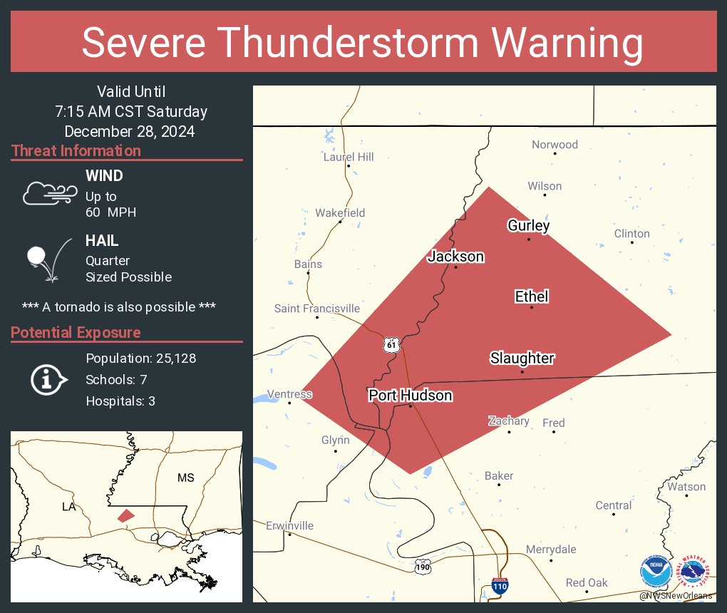
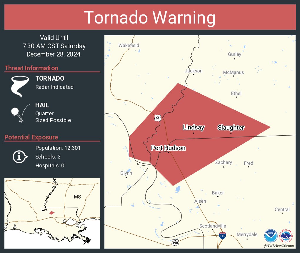
Got gnarly in the Port Hudson area.
Posted on 12/28/24 at 7:11 am to NOLA1128
That rotation passed directly over Port hudson

Posted on 12/28/24 at 7:11 am to Roll Tide Ravens
Over in Ponchatoula we have been getting a lot of lightning and alittle thunder since about 5:30am. Not much rain, looks like it will be a rough day if predictions hold up.
Posted on 12/28/24 at 7:21 am to Roll Tide Ravens
Need to travel back to LC from Covington today. I can be flexible on when I leave. Better to leave this morning or wait til later?
Posted on 12/28/24 at 7:28 am to Question
quote:
Need to travel back to LC from Covington today. I can be flexible on when I leave. Better to leave this morning or wait til later?
I would check radar and get on the road as early as possible. Less traffic and you can take your time in case you need pull off it gets bad. Typical weather gets worse as the day goes along in situations like this.

Posted on 12/28/24 at 7:38 am to Ponchy Tiger
Death, taxes, late December severe weather in the south.
So gay
So gay

Posted on 12/28/24 at 7:49 am to S
The yard never dries up this time of year plus you get crawfish holes. More rain today after the deluge night before last. Yippee!
Posted on 12/28/24 at 7:49 am to Ponchy Tiger
that storm that moved over Hammond about 630 was intense but thankfully short. Crazy lightning and a little hail
Posted on 12/28/24 at 8:09 am to Roll Tide Ravens
SPC just keeps increasing the moderate risk area at every update
Posted on 12/28/24 at 8:10 am to Roll Tide Ravens
Weird here .... Very dense fog, raining, thunder and a nearby likely approaching severe thunderstorm. I was about to take a late pasture walk when I heard the thunder.
Posted on 12/28/24 at 8:16 am to Roll Tide Ravens
quote:
SLIGHT Dallas, TX...Fort Worth, TX...New Orleans, LA...Arlington, TX...Plano, TX..
This is one thing that aggravates me about the SPC. They will lazily just list key cities in concerned areas based solely on population.
Here you see Dallas, Ft. Worth AND Arlington all listed. Rarely would you ever get a area of concern and not be either all 3 adjacent cities or none of the 3.
In this case today, by picking solely on population, cities like Birmingham and Huntsville, AL are not listed.
This post was edited on 12/28/24 at 8:18 am

 Page 1 of 26

Popular
Back to top