- My Forums
- Tiger Rant
- LSU Recruiting
- SEC Rant
- Saints Talk
- Pelicans Talk
- More Sports Board
- Fantasy Sports
- Golf Board
- Soccer Board
- O-T Lounge
- Tech Board
- Home/Garden Board
- Outdoor Board
- Health/Fitness Board
- Movie/TV Board
- Book Board
- Music Board
- Political Talk
- Money Talk
- Fark Board
- Gaming Board
- Travel Board
- Food/Drink Board
- Ticket Exchange
- TD Help Board
Customize My Forums- View All Forums
- Show Left Links
- Topic Sort Options
- Trending Topics
- Recent Topics
- Active Topics
Started By
Message
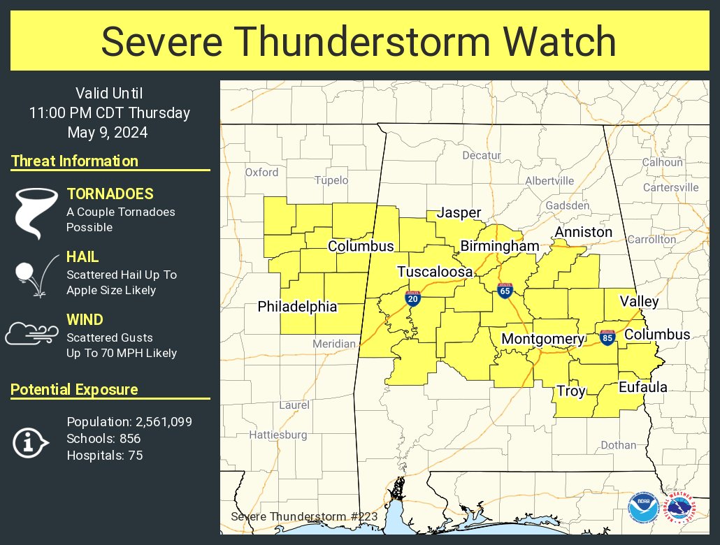
re: Severe Weather Rolls On: May 7-10, 2024
Posted on 5/9/24 at 4:53 pm to George Dickel

Posted on 5/9/24 at 4:53 pm to George Dickel

 2
2

Posted on 5/9/24 at 4:54 pm to Roll Tide Ravens
Tennis ball and baseball size hail belting Texas.
Posted on 5/9/24 at 4:59 pm to Roll Tide Ravens
Posted on 5/9/24 at 5:02 pm to Roll Tide Ravens
I hope the weather guy who has control of the remote takes a day off soon.
Posted on 5/9/24 at 5:03 pm to LegendInMyMind
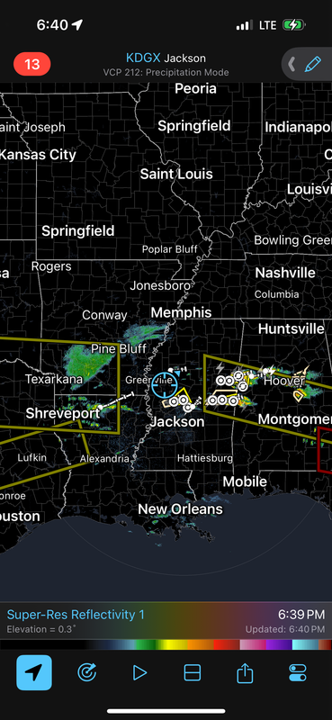
Tornado Warning
TXC159-387-449-092245-
/O.NEW.KSHV.TO.W.0016.240509T2159Z-240509T2245Z/
BULLETIN - EAS ACTIVATION REQUESTED
Tornado Warning
National Weather Service Shreveport LA
459 PM CDT Thu May 9 2024
The National Weather Service in Shreveport has issued a
* Tornado Warning for...
Northern Franklin County in northeastern Texas...
Northern Titus County in northeastern Texas...
Southern Red River County in northeastern Texas...
* Until 545 PM CDT.
* At 458 PM CDT, a confirmed tornado was located just southwest
of Bogata, moving east at 45 mph.
HAZARD...Damaging tornado and tennis ball size hail.
SOURCE...Weather spotters confirmed tornado.
IMPACT...Flying debris will be dangerous to those caught without
shelter. Mobile homes will be damaged or destroyed.
Damage to roofs, windows, and vehicles will occur. Tree
damage is likely.
* The tornado will be near...
Bogata around 505 PM CDT.
Wilkerson around 520 PM CDT.
Other locations impacted by this tornadic thunderstorm include
Johntown, Cuthand, Talco, Harts Bluff, and Deport.
PRECAUTIONARY/PREPAREDNESS ACTIONS...
To repeat, a tornado is on the ground. TAKE COVER NOW! Move to a
basement or an interior room on the lowest floor of a sturdy
building. Avoid windows. If you are outdoors, in a mobile home, or in
a vehicle, move to the closest substantial shelter and protect
yourself from flying debris.
&&
LAT...LON 3355 9531 3352 9479 3328 9482 3335 9531
TIME...MOT...LOC 2158Z 276DEG 38KT 3342 9530
TORNADO...OBSERVED
MAX HAIL SIZE...2.50 IN
This post was edited on 5/9/24 at 5:05 pm
Posted on 5/9/24 at 5:03 pm to Roll Tide Ravens
quote:
A family of three survived the Henagar tornado in this storm shelter. #alwx
Thank you so much for captioning that picture. I saw that building on the drone fly over and thought it was just a cheap old Big Box store storage shed and how odd it was for it to survive while the nearby house was flattened.
Well, darn, and very good for the home owner to have been prepared.
Do you know any more about where that shelter came from?

Posted on 5/9/24 at 5:06 pm to LegendInMyMind
Mother Nature is still pissed off.
Posted on 5/9/24 at 5:07 pm to chinhoyang
Tornado Warning
TXC119-277-092230-
/O.NEW.KFWD.TO.W.0031.240509T2154Z-240509T2230Z/
BULLETIN - EAS ACTIVATION REQUESTED
Tornado Warning
National Weather Service Fort Worth TX
454 PM CDT Thu May 9 2024
The National Weather Service in Fort Worth has issued a
* Tornado Warning for...
Northeastern Delta County in north central Texas...
Southeastern Lamar County in north central Texas...
* Until 530 PM CDT.
* At 454 PM CDT, a confirmed tornado was located 8 miles south of
Pattonville, moving east at 25 mph.
HAZARD...Damaging tornado and hail up to two inches in diameter.
SOURCE...Weather spotters confirmed tornado.
IMPACT...Flying debris will be dangerous to those caught without
shelter. Mobile homes will be damaged or destroyed.
Damage to roofs, windows, and vehicles will occur. Tree
damage is likely.
* This tornadic thunderstorm will remain over mainly rural areas of
northeastern Delta and southeastern Lamar Counties, including the
following locations... Clardy, Taylor Town, Milton, Cunningham,
Minter, and Deport.
PRECAUTIONARY/PREPAREDNESS ACTIONS...
To repeat, a tornado is on the ground. TAKE COVER NOW! Move to an
interior room on the lowest floor of a sturdy building. Avoid
windows. If you are outdoors, in a mobile home, or in a vehicle, move
to the closest substantial shelter and protect yourself from flying
debris.
&&
LAT...LON 3338 9531 3336 9533 3336 9535 3337 9537
3337 9544 3354 9546 3355 9531
TIME...MOT...LOC 2154Z 262DEG 21KT 3346 9537
TORNADO...OBSERVED
MAX HAIL SIZE...2.00 IN
Posted on 5/9/24 at 5:08 pm to real turf fan
quote:
Do you know any more about where that shelter came from?
There are quite a few companies building those type shelters now. I know some folks who do foundation and concrete work for them. The structures are built by a few companies, and the good ones handle their own installs. They do work all over and shelters of all sizes.
Posted on 5/9/24 at 5:09 pm to dukke v
quote:
Mother Nature is still pissed off.
Nature isn't pissed, Nature just is.
Posted on 5/9/24 at 5:09 pm to LegendInMyMind
The dew point at my location is 79.5 degrees.
Posted on 5/9/24 at 5:15 pm to LegendInMyMind
Can’t stop it. Most powerful element in the world.
Posted on 5/9/24 at 5:23 pm to tarzana
quote:
It's funny how Jeb Clampett and The Mamas & The Papas had the right idea back in the 1960's, and that was years before climate change kicked in, in earnest.
quote:
tarzana
STFU
This post was edited on 5/9/24 at 6:41 pm
Posted on 5/9/24 at 6:00 pm to Roll Tide Ravens
Posted on 5/9/24 at 6:05 pm to Roll Tide Ravens
I don't know if that's a tornado or the fiberglass boat we set on fire back in '04 still burning.
Posted on 5/9/24 at 6:16 pm to Roll Tide Ravens
NWS reported the twister that ravaged Brigadoon in SW Limestone county, AL, on the TN River was an EF3.
Posted on 5/9/24 at 6:27 pm to George Dickel
Did you see that on the news? They haven't posted it to Xwitter yet.
Posted on 5/9/24 at 6:37 pm to LegendInMyMind
Yes… at 6 pm on TV48.
Posted on 5/9/24 at 6:42 pm to LegendInMyMind
Either I’m safe here in no man’s land or I’m about to feel what Riley Reid did in all those videos and get it from both ends
Posted on 5/9/24 at 6:46 pm to deltaland
Would someone care to explain to me why the Storm Prediction Center's Storm Report for yesterday shows no tornadoes hitting anywhere in Alabama?

 Page 33 of 36

Popular
Back to top