- My Forums
- Tiger Rant
- LSU Recruiting
- SEC Rant
- Saints Talk
- Pelicans Talk
- More Sports Board
- Fantasy Sports
- Golf Board
- Soccer Board
- O-T Lounge
- Tech Board
- Home/Garden Board
- Outdoor Board
- Health/Fitness Board
- Movie/TV Board
- Book Board
- Music Board
- Political Talk
- Money Talk
- Fark Board
- Gaming Board
- Travel Board
- Food/Drink Board
- Ticket Exchange
- TD Help Board
Customize My Forums- View All Forums
- Show Left Links
- Topic Sort Options
- Trending Topics
- Recent Topics
- Active Topics
Started By
Message

 0
0

Posted on 5/6/24 at 11:33 pm to Pedro
quote:
Cell closing in on Hutchinson, Ks is trying to get its act together
I spent the better part of two hours on the back of this one tonight. Did something really weird just south of Gypsum. It looked like it was trying to be a funnel cloud but it wasn't rotating and there wasn't anything definitely attached to the base but there were a bunch of super low hanging clouds real close together in the classic cone pattern. Only stayed that way for maybe 45 seconds but I had never seen anything act like that before. Kind of looked like someone trying to make a tornado out of Legos. It tried to form a bit of a wall cloud by Abilene when they put a warning on it but it never really had its act together very long. Still it was probably as good of a strom as any to chase in Kansas today.
Every once in a while I'll poke around in a neighboring state but I'm usually not real crazy about it. I've lived in Kansas my whole life and I have a pretty good idea which county roads you can go down and which you can't. I don't have that knowledge for any other state and it makes a difference. Even tonight a county road that is normally a good shortcut to take had a bridge out for construction and was closed which made me take an unplanned detour through the residential section of Abilene.
Posted on 5/6/24 at 11:37 pm to 88Wildcat
Yea having the knowledge helps a lot. Also helps that this state is incredibly easy to navigate since pretty much everything is laid out in a grid. Even in the cities it’s almost impossible to get lost,
I’m jealous that seemed like a fun one to track. Looks like the keeper did its job for Wichita again
I’m jealous that seemed like a fun one to track. Looks like the keeper did its job for Wichita again
This post was edited on 5/6/24 at 11:39 pm
Posted on 5/6/24 at 11:39 pm to OU Guy
Power flashes in Moore and Norman, at least 10 so far. 70-80 wonds
Wind event not tornado
Wind event not tornado
Posted on 5/6/24 at 11:41 pm to OU Guy
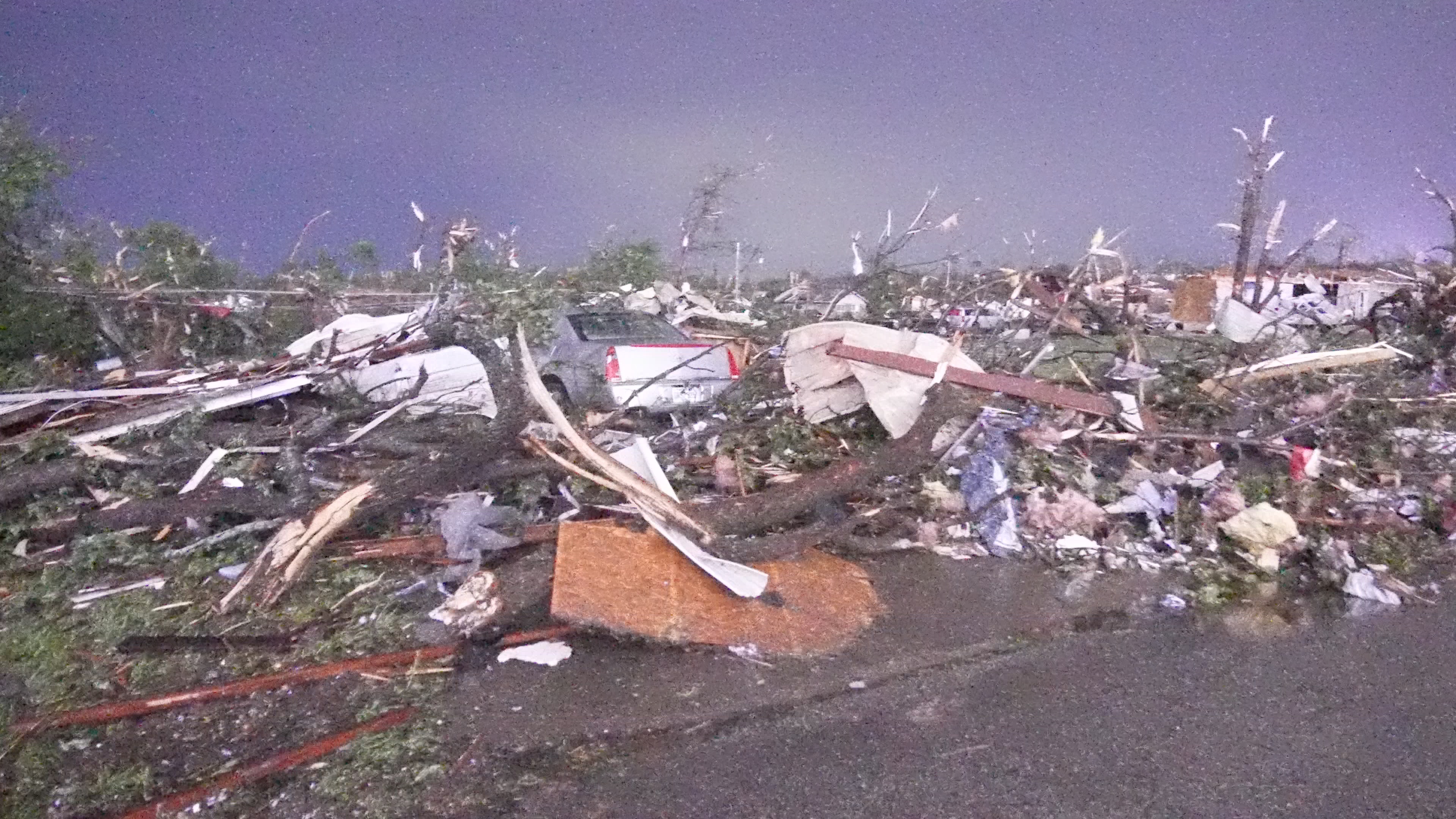
Confirmed tor NE of Joplin
Posted on 5/6/24 at 11:42 pm to Pedro
It's not so much a matter of getting lost as it is a matter of knowing which roads stay paved and which turn to gravel or worse, You don't want to get in a situation where you have to outrun something on a road designed more for a covered wagon than for a car or truck.
Posted on 5/6/24 at 11:42 pm to OU Guy
quote:
A TORNADO WARNING REMAINS IN EFFECT UNTIL MIDNIGHT CDT FOR SOUTHEASTERN BARTON AND EASTERN JASPER COUNTIES...
At 1138 PM CDT, a confirmed tornado was located over Carthage, moving northeast at 65 mph.
HAZARD...Damaging tornado.
SOURCE...Radar confirmed tornado.
IMPACT...Flying debris will be dangerous to those caught without shelter. Mobile homes will be damaged or destroyed. Damage to roofs, windows, and vehicles will occur. Tree damage is likely.
Locations impacted include... Carthage, Carterville, Jasper, Golden City, Carytown, Brooklyn Heights, Maple Grove, and Dudenville.
This includes Interstate 49 between mile markers 39 and 56.
This post was edited on 5/6/24 at 11:43 pm
Posted on 5/6/24 at 11:44 pm to OU Guy
Tornado warming for South metro on top of Crossroads Mall
This post was edited on 5/6/24 at 11:45 pm
Posted on 5/6/24 at 11:44 pm to OU Guy
Tornado warning for Oklahoma City
Posted on 5/6/24 at 11:44 pm to NorthEndZone
New Tornado in Valleybrooke. Hope the strip clubs make it
Posted on 5/6/24 at 11:44 pm to Pedro
Sure looks like we may be gearing up for an overnight D-word.
Posted on 5/6/24 at 11:46 pm to LegendInMyMind

Posted on 5/6/24 at 11:48 pm to OU Guy

Posted on 5/7/24 at 12:00 am to OU Guy
In Choctaw now. Lights flickering here so its likely the power issues down south and maybe switching stations? I didn’t get those big winds and my power is underground (my neighborhood is all underground). But its above ground from power station to our neighborhood about 3 miles.
Posted on 5/7/24 at 12:01 am to OU Guy
Probably so. You'll get some good wind from that if you're in Choctaw.
Posted on 5/7/24 at 12:06 am to LegendInMyMind
quote:
Probably so. You'll get some good wind from that if you're in Choctaw.
My bad, I’m not on Choctaw the tornado was.
But my power on a different part of metro was flickering seems good now
TV showing pics of downed power lines (well 45 degree angle). Strong winds hit those areas
Posted on 5/7/24 at 12:15 am to OU Guy
Outage Summary
Total Customers Affected
25,914
Thats OG&E which does a lot of areas.
Moore reports that 45% of their customers are without power
Total Customers Affected
25,914
Thats OG&E which does a lot of areas.
Moore reports that 45% of their customers are without power
Posted on 5/7/24 at 12:23 am to OU Guy
Lots of cussing so not safe for most work places
Crazy video
Crazy video
Loading Twitter/X Embed...
If tweet fails to load, click here.Posted on 5/7/24 at 12:23 am to OU Guy
Barnsdall
Posted on 5/7/24 at 12:25 am to OU Guy
Sure looks like a violent tornado.

 Page 27 of 30

Popular
Back to top