- My Forums
- Tiger Rant
- LSU Recruiting
- SEC Rant
- Saints Talk
- Pelicans Talk
- More Sports Board
- Fantasy Sports
- Golf Board
- Soccer Board
- O-T Lounge
- Tech Board
- Home/Garden Board
- Outdoor Board
- Health/Fitness Board
- Movie/TV Board
- Book Board
- Music Board
- Political Talk
- Money Talk
- Fark Board
- Gaming Board
- Travel Board
- Food/Drink Board
- Ticket Exchange
- TD Help Board
Customize My Forums- View All Forums
- Show Left Links
- Topic Sort Options
- Trending Topics
- Recent Topics
- Active Topics
Started By
Message
New online maps to show how deep the water may have gotten in your neighborhood in 2016
Posted on 11/28/22 at 8:25 am
Posted on 11/28/22 at 8:25 am
quote:
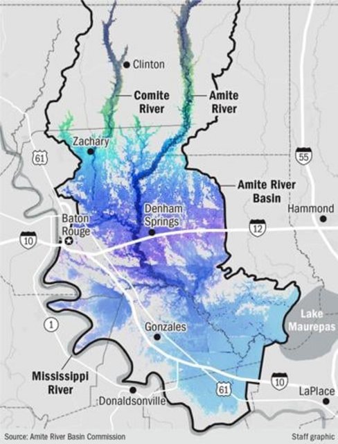
A first-of-its-kind interactive map shows the sheer scale of the 2016 floods that devastated the Baton Rouge region.
The online tool, created after years of work by the Amite River Basin Commission, shows how the floods swamped land stretching across more than 67 miles, from as far north as the Mississippi state line to as far south as the swampy fringes of northern Convent, along La. 3125.
quote:
Commission officials say the map's real power, however, isn't the big picture overview — it's the comprehensive detail of exactly what places flooded, and how badly.
Once the map goes live in the coming days at the commission website, amitebasin.org, homeowners will be able to zoom in and find flooding levels and flooding depths at the individual house level. That could provide far more powerful information than static federal flood risk maps, commission officials and their consultants said.
LINK
 9
9


Posted on 11/28/22 at 8:27 am to member12
That’s helpful for sure. Years ago the advocate had a map that only showed where the flood waters were but not the depth. Glad to see it’s updated.
Posted on 11/28/22 at 8:27 am to member12
Don’t click the link. It’s the advocate and the actual map isn’t live yet.

Posted on 11/28/22 at 8:35 am to member12
Why would they write this article and the map not even be working yet? Wasting everyones time...

Posted on 11/28/22 at 8:43 am to member12
Hard to believe it’s been more than 6 years
Posted on 11/28/22 at 4:38 pm to member12
This map should’ve already been live.
Posted on 11/28/22 at 4:54 pm to member12
This data isn't actual 2016 flood depth. It's based on the flood model developed by the LA Watershed Initiative. They used USGS 2016 high water marks to calibrate the model, so it's pretty good, but not 100%. Once they calibrated the model using the 2016 flood, they ran multiple what-if scenarios to help municipalities better plan in the future. The goal is to input proposed new developments into the model and determine the impact on flooding before the development is approved for construction.

Posted on 11/28/22 at 5:06 pm to member12
So where's the fricking map?

Posted on 11/28/22 at 5:08 pm to member12
Crazy how the draining of the swamp saved everyone on bayou fountain

Posted on 11/28/22 at 5:32 pm to member12
That's easy to figure. The waterline was 6' in my brother's house just north of Hooper and Tanglewood subdivision. My step mom had about 4' in her house in Tanglewood. I don't need a map to tell me that.

 Page 1 of 1


Popular
Back to top