- My Forums
- Tiger Rant
- LSU Recruiting
- SEC Rant
- Saints Talk
- Pelicans Talk
- More Sports Board
- Fantasy Sports
- Golf Board
- Soccer Board
- O-T Lounge
- Tech Board
- Home/Garden Board
- Outdoor Board
- Health/Fitness Board
- Movie/TV Board
- Book Board
- Music Board
- Political Talk
- Money Talk
- Fark Board
- Gaming Board
- Travel Board
- Food/Drink Board
- Ticket Exchange
- TD Help Board
Customize My Forums- View All Forums
- Show Left Links
- Topic Sort Options
- Trending Topics
- Recent Topics
- Active Topics
Started By
Message
Manchac/ Ponchatrain Question
Posted on 9/1/19 at 12:02 pm
Posted on 9/1/19 at 12:02 pm
This is probably a dumb question so I apologize in advance. Coming out of Manchac into Ponchatrain and turning left (heading for tchefuncte), there is a series of wooden poles about 50 yards wide and 1-200 yards long. Is that traps or is it marking an underground object? I went to the right of it but just had me curious. Thanks.
 3
3

Posted on 9/1/19 at 12:09 pm to cryptkeeper
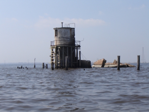
That’s the old light house. You need to head out about 1 mile before turning left.
Posted on 9/1/19 at 1:57 pm to Lanitrofish
Thank you.
Posted on 9/1/19 at 2:03 pm to cryptkeeper
Like they said, it’s where the old lighthouse was. It’s very very shallow, hence why there was a lighthouse there. I usually head out straight east until the taller power line poles at the entrance to the Tangipahoa river become visible on the horizon before I start heading north.
Posted on 9/1/19 at 2:33 pm to cryptkeeper
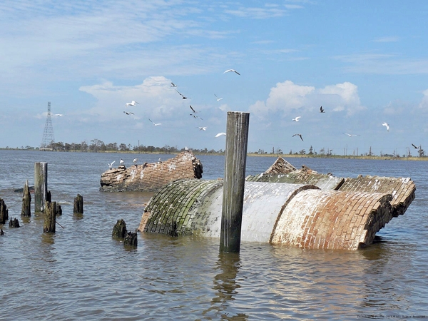
The original lighthouse was built before the Civil War on land near this exact same area. Hurricanes destroyed 3 previous lighthouses and the one pictured below eventually fell after Hurricane Isaac in 2012. Amazing in just 150+ years, the coastline where land once was has eroded approximately 400 yards.
Posted on 9/2/19 at 7:41 am to Got Blaze
Man I hate to see that.
The lighthouse was just that cool old landmark that I caught redfish around it.
The lighthouse was just that cool old landmark that I caught redfish around it.
Posted on 9/2/19 at 9:56 am to johnnyrocket
They have a couple of articles on the history of the light houses but the on there was on land the 3 before it were also on land and each on was further out. I think the article said 1/2 mile out from this one.

Posted on 9/2/19 at 1:22 pm to Got Blaze
What about all those wood pilings sticking out of the water alongside I-10 over the spillway? Any idea what those are from?
Posted on 9/2/19 at 3:21 pm to Tiger Prawn
quote:
What about all those wood pilings sticking out of the water alongside I-10 over the spillway?
I’ve seen those same pilings for 40+ years when fishing and traveling on I-10. No clue but if I had to take a wild-arse guess, I bet the COE erected those pilings decades ago as a barrier to divert river water more Easterly when the flood gates are opened.
I called and left a msg. with the COE in Norco and will reply back with what they tell me about the pilings

Posted on 9/2/19 at 4:52 pm to Got Blaze
They had a lot more piling that ran parallel to the bridge. Many of this are now gone. I always figured that was to stop trees from floating in to the lake
Posted on 9/2/19 at 10:40 pm to Got Blaze
quote:Haha damn. Thats some dedication to finding the answer
I called and left a msg. with the COE in Norco and will reply back with what they tell me about the pilings

Posted on 9/2/19 at 11:51 pm to Tiger Prawn
quote:
What about all those wood pilings sticking out of the water alongside I-10 over the spillway? Any idea what those are from?
I’m pretty sure those are remnants from the German Settlement that used to be in the area. I’ll post more info once I find it.
Posted on 9/3/19 at 4:46 am to Me Bite
My dad told me there used to be a seawall there. I'm old now so that was probably in the 40's? When I-10 opened they was a still a line of them.
Posted on 9/3/19 at 7:29 am to Me Bite
quote:I only knew about the Frenier and Ruddock settlements along the southwest Lake P shores. I assume this German settlement must have pre-dated those?
I’m pretty sure those are remnants from the German Settlement that used to be in the area. I’ll post more info once I find it.
Posted on 9/3/19 at 8:04 am to Tiger Prawn
I believe the pilings along I-10 in the spillway was from an old railroad line from Baton Rouge to Lafayette.

 Page 1 of 1


Popular
Back to top