- My Forums
- Tiger Rant
- LSU Recruiting
- SEC Rant
- Saints Talk
- Pelicans Talk
- More Sports Board
- Fantasy Sports
- Golf Board
- Soccer Board
- O-T Lounge
- Tech Board
- Home/Garden Board
- Outdoor Board
- Health/Fitness Board
- Movie/TV Board
- Book Board
- Music Board
- Political Talk
- Money Talk
- Fark Board
- Gaming Board
- Travel Board
- Food/Drink Board
- Ticket Exchange
- TD Help Board
Customize My Forums- View All Forums
- Show Left Links
- Topic Sort Options
- Trending Topics
- Recent Topics
- Active Topics
Started By
Message
Lake Pontchartrain Tarpon?
Posted on 9/9/15 at 3:30 pm
Posted on 9/9/15 at 3:30 pm
Heard some reports this week that the tarpon are thick in the Lake right now. Anyone fishing for them before they head south?
 5
5


Posted on 9/9/15 at 3:32 pm to MrLSU
Look for deep holes and they'll be there.

Posted on 9/9/15 at 3:52 pm to MrLSU
Tarpon? What tarpon?

Posted on 9/9/15 at 3:56 pm to KingRanch
quote:
Look for deep holes and they'll be there.
Past the lakefront airport........
Posted on 9/9/15 at 4:02 pm to Barf
I will take someone on a sight fishing trip in exchange for a legit shot at a tarpon in the lake. Can use my boat for both if wanted, but I need proof that you know how and where to catch said tarpon.
Posted on 9/9/15 at 4:09 pm to Fifthstring

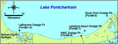
THE CLOVER LEAF" DREDGE HOLE IN LAKE PONTCHARTRAIN
.
~ ADDITIONAL INFORMATION FROM Captain Paul ~
After being stumped by not knowing where the “CLOVER LEAF” was located in LAKE PONTCHARTRAIN and with the help of “TARPON TOM,” one of our readers, I researched the dredging that was done in Lake Pontchartrain. I found a location that was used to build the levee and fill the Little Woods Canal along the south shore of Lake Pontchartrain from South Point ~ Point aux Herbes to Little Woods.
This dredging resulted in one of the four dredge holes located near the south shore of Lake Pontchartrain.
The University of New Orleans Coastal Research Laboratory (UNOCRL) and the USGS formed a joint partnership in 1998 to collect hydrographic data along the south shore of Lake Pontchartrain to document bathymetric change since the early 1900's. The data they collected was processed and computer generated to create a bathymetric map of Lake Pontchartrain.
That data according to the U.S. Geological Survey (USGS) ~ UNO in their joint survey, which was conducted in 2002, indicated that the bathymetric data (water depth measurement) of the SOUTH POINT hole is approximately 55.8 feet deep.
“The hole,” again according to USGS, “was created when sand was pumped from the Lake bottom to fill the Little Woods Canal, which ran parallel to the shoreline. Information from Orleans Levee District suggests that the sand was used to fill the canal prior to building the hurricane protection levee. Records show that clay from a borrow area near Howze Beach on the north shore was transported to the same site to cap the sand layer. This work took place in the 1970's. Since their excavations, the pits have essentially become giant sediment traps, slowly accumulating sediment from the surrounding Lake bottom.”
These dredge holes may not now be as pronounced or even be noticeable with normal consumer depth finding equipment, but I have located an APPROXIMATE position for the hole(s).
I suggest that you use these positions as a starting point and, while using your depth finder, search the area between the three listed positions. If they have not been entirely filled in by sediment, you should notice a difference in the lake bottom around the area.
The large dredge hole that resembles a three leaf CLOVER was reported to be located about 1.5 miles from South Point at a bearing of 241° (mag) and about .75 miles from the shore line at the rail road tracks.
These Dredge holes are West-Southwest of South Point~ Point aux Herbes.
The NORTHERN most part of the hole is / was located at or about 30°08.522’ N. Latitude ~ 89°54.306’W. Longitude.
The hole extends from this point towards the South west for about .6 of a mile and to the Southeast for about .5 of a mile.
The SOUTH EASTERN most part of the dredge hole is / was located at or about 30° 08.136’ N. Latitude ~ 89°54.035’W. Longitude. It is about .5 miles from the northern most location of the hole.
The SOUTH WESTERN most part of the hole is / was located at or about
30° 08040’ N. Latitude ~ 89°54.429’W. Longitude. It is about .6 miles from the northern point and .4 of a mile from the south eastern point. This part of the Clover leaf pattern is shown to be the deepest part of the three part hole.
Thanks again “TARPON TOM” for bring the location to the attention of our readers.
Unless otherwise specified, all positions are stated as H,DDD,MM.mmm and were determined using WGS 84 DATUM; All Headings/bearings/courses are in Magnetic Degrees and STATUTE miles.
~ Captain Paul ~
- See more at: LINK
Posted on 9/9/15 at 4:24 pm to MrLSU
MrLSU
Thanks!
Thanks!
Posted on 9/9/15 at 4:46 pm to Fifthstring
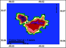
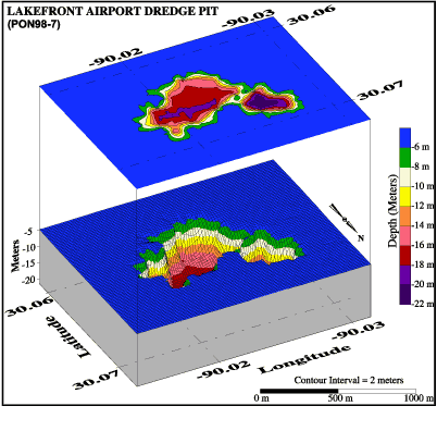
In 1998, a partnership was formed between the UNOCRL and the USGS to collect hydrographic data along the south shore of Lake Pontchartrain in order to document bathymetric change since the early 1900's. These hydrographic data were processed and computer-generated to produce bathymetric maps. Locations of dredge-pits and specific study areas are shown in Figure 38.
One of four significant holes in the Lake bottom on the south shore mapped by this survey is near South Point. The bathymetric data show that this hole is approximately 17 m (55.8 ft) deep.
The hole was created when sand was pumped from the Lake bottom to fill the Little Woods Canal, which ran parallel to the shoreline. Information from Orleans Levee District suggests that the sand was used to fill the canal prior to building the hurricane protection levee. Records show that clay from a borrow area near Howze Beach on the north shore was transported to the same site to cap the sand layer. This work took place in the 1970's.
In 1998, a partnership was formed between the UNOCRL and the USGS to collect hydrographic data along the south shore of Lake Pontchartrain in order to document bathymetric change since the early 1900's. These hydrographic data were processed and computer generated to produce bathymetric maps. Location of dredge- pits and specific study areas are shown in Figure 34.
These bathymetric maps reflect two adjacent dredge holes located to the northeast of the Lakefront Airport runway (Figures 35, 36 and 37). The holes range in depth from 20 to 22 m (65.6-72.2 ft). Orleans Levee District documents show that this pit was excavated between 1977 and 1980, the material being used for an airport expansion project (Orleans Levee District communication).
This post was edited on 9/9/15 at 4:49 pm
Posted on 9/9/15 at 6:10 pm to Fifthstring
I've tried 4x never seen one. Did get into two huge schools of Jack's though.
Posted on 9/9/15 at 6:17 pm to 2indapink
I have been told by an old timer that they used to use to free line large, live mullet over the holes.
Posted on 9/9/15 at 7:20 pm to doublecutter
I would like to know how many tons of clam shells came out that hole. Used to fish there when I was a kid from Lincoln Beach.  Grew up in that hood.
Posted on 9/9/15 at 8:36 pm to fishfighter
Fish, you been out that way lately? It gets pretty dark in that area now.
When I was a little kid, we lived in Pines Village, off Downman Rd and Morrison it was a solid middle class neighborhood. Nice, clean, well kept homes, now it is a shithole.
When I was a little kid, we lived in Pines Village, off Downman Rd and Morrison it was a solid middle class neighborhood. Nice, clean, well kept homes, now it is a shithole.
Posted on 9/9/15 at 10:02 pm to doublecutter
I've talked to people who claim to have caught tarpon in the Rigolets. They anchor up and basically chum all day. I don't know much more than that though.
Over the last 2 weekends I have run through the Rigolets 5 times. 3 of those I have noticed a 30-something Twin Vee with a tower anchored up in deep water (looks like they are in 80-95ft+ out in front of the old light house). There's not much reason to be anchored there to my knowledge, unless there are some Bull Reds running deep in the pass right now. There's a hole in there that 109ft deep.
Over the last 2 weekends I have run through the Rigolets 5 times. 3 of those I have noticed a 30-something Twin Vee with a tower anchored up in deep water (looks like they are in 80-95ft+ out in front of the old light house). There's not much reason to be anchored there to my knowledge, unless there are some Bull Reds running deep in the pass right now. There's a hole in there that 109ft deep.
Posted on 9/10/15 at 12:00 pm to RingLeader
quote:
Over the last 2 weekends I have run through the Rigolets 5 times. 3 of those I have noticed a 30-something Twin Vee with a tower anchored up in deep water (looks like they are in 80-95ft+ out in front of the old light house). There's not much reason to be anchored there to my knowledge, unless there are some Bull Reds running deep in the pass right now. There's a hole in there that 109ft deep.
The old Lighthouse House off of Rigolets Pass is a known Tarpon area in the lake as well. The boat you saw is definitely fishing for them. The hole and the drop-offs to the hole are prime spots to catch tarpon in the lake. There is another hole by the mouth of Chef Pass that was also good in years past.
Posted on 9/10/15 at 12:33 pm to MrLSU
In Boca Grande pass in FL, they use live pinfish deep and drift over the edge of the hole in the pass. The tarpon are stacked down behind the edge ambushing bait as drifts over. This is in late spring.
Posted on 9/10/15 at 12:43 pm to Nawlens Gator
There may or may not be someone taking them on fly in the lake.
Posted on 9/10/15 at 12:43 pm to Nawlens Gator
There is a hole just north and East (~500yd) of the end of the peir that juts out from Lakefront airport. It gets to about 45' deep and is several hundred yards wide. The side slopes a re pretty drastic (like a 1V on 4H slope). I have crossed it several times very recently with my boat that I keep out at South Shore Harbor.
That would be the easiest place for me to try.
Cut mullet you say? Or live mullet? Either can be obtained for free with a cast net!
That would be the easiest place for me to try.
Cut mullet you say? Or live mullet? Either can be obtained for free with a cast net!
Posted on 9/10/15 at 12:45 pm to Barf
quote:
There may or may not be someone taking them on fly in the lake.
Posted on 9/10/15 at 1:07 pm to doublecutter
quote:
When I was a little kid, we lived in Pines Village, off Downman Rd and Morrison it was a solid middle class neighborhood. Nice, clean, well kept homes, now it is a shithole.
All New Orleans east is a shite hole for the last 25+ years.
Posted on 9/10/15 at 1:55 pm to Sid in Lakeshore
quote:
Cut mullet you say? Or live mullet? Either can be obtained for free with a cast net!
We fish for them with live mullet or large live pogies on a 9/0-11/0 circle hook with a 80 pound flourocarbon leader free lined. I know some folks who used live bull croaker and white trout too. Cutting it up tends to attract catfish and sharks.

 Page 1 of 2

Popular
Back to top