- My Forums
- Tiger Rant
- LSU Recruiting
- SEC Rant
- Saints Talk
- Pelicans Talk
- More Sports Board
- Fantasy Sports
- Golf Board
- Soccer Board
- O-T Lounge
- Tech Board
- Home/Garden Board
- Outdoor Board
- Health/Fitness Board
- Movie/TV Board
- Book Board
- Music Board
- Political Talk
- Money Talk
- Fark Board
- Gaming Board
- Travel Board
- Food/Drink Board
- Ticket Exchange
- TD Help Board
Customize My Forums- View All Forums
- Show Left Links
- Topic Sort Options
- Trending Topics
- Recent Topics
- Active Topics
Started By
Message
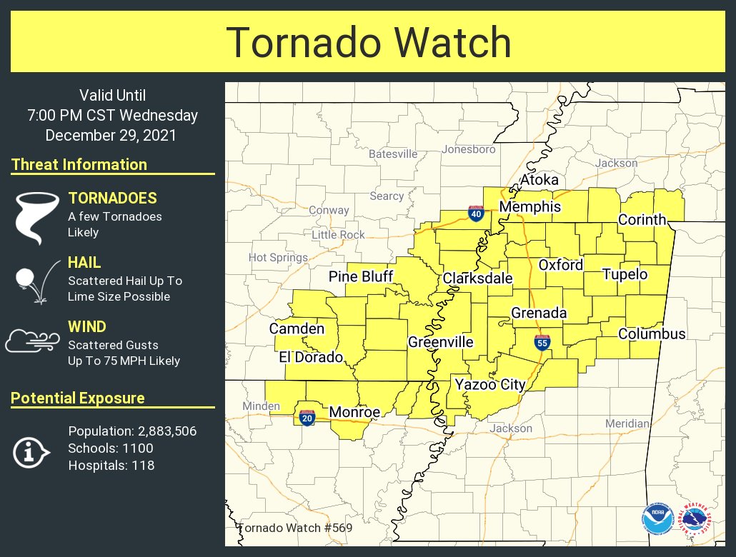
re: Wednesday weather thread: MS, AL, LA, TN, Enhanced for MS, AL, TN
Posted on 12/29/21 at 12:20 pm to LegendInMyMind

Posted on 12/29/21 at 12:20 pm to LegendInMyMind
 1
1

Posted on 12/29/21 at 12:24 pm to Roll Tide Ravens
I'm seeing some folks on weather message boards talk about the placement of the highest tornado risk. Right now, Tupelo is in the hatched area, however, Tupelo has a temp 59 degrees with a dewpoint of 57 degrees. It would take some major WAA to ripen the atmosphere back up enough for severe storms. Perhaps the greater risk needs to be shifted south or southeast. Birmingham is partly sunny with a temp of 73 and with a dewpoint of 69.
This post was edited on 12/29/21 at 12:24 pm

Posted on 12/29/21 at 12:26 pm to Roll Tide Ravens
quote:
dewpoint of 69.
Nice
Posted on 12/29/21 at 12:26 pm to Roll Tide Ravens
I thought the same. Rain all morning took the energy out of the air farther north.
It’s been sunny and humid as frick here. 78 degrees right now dew point of 69
It’s been sunny and humid as frick here. 78 degrees right now dew point of 69
Posted on 12/29/21 at 12:27 pm to Roll Tide Ravens
That's why I looked at the obs in Greenville, MS. They are at 77°/68° last hour.
Posted on 12/29/21 at 12:28 pm to deltaland
quote:
Rain all morning took the energy out of the air farther north.
Don't sleep on the Northern mode, though. We will clear and there are boundaries everywhere. Whatever forma downstream may have enough support to the NE to keep going.
Posted on 12/29/21 at 12:29 pm to LegendInMyMind
quote:
This area, outside of the Enhanced Risk area, is looking concerning.
Oh yay for me
Posted on 12/29/21 at 12:29 pm to LegendInMyMind
I’m south of indianola 
Posted on 12/29/21 at 12:31 pm to deltaland
Has your wind picked up over the past couple hours?
Posted on 12/29/21 at 12:33 pm to LegendInMyMind
Currently blowing from SW at 20 mph
And the damn sun is out. Had a couple inches of rain this morning and it feels like a sauna outside
It’s really not a good feeling tbh knowing what feeds these storms
And the damn sun is out. Had a couple inches of rain this morning and it feels like a sauna outside
It’s really not a good feeling tbh knowing what feeds these storms
This post was edited on 12/29/21 at 12:37 pm
Posted on 12/29/21 at 12:42 pm to deltaland
Yeah, I think you may have legit concern this time around.
Posted on 12/29/21 at 1:04 pm to LegendInMyMind
Cells in NE Louisiana popping up
The cluster in southern Arkansas worried me because they’re already organized cells. When they cross the river into this favorable atmosphere they could get nasty
The cluster in southern Arkansas worried me because they’re already organized cells. When they cross the river into this favorable atmosphere they could get nasty
This post was edited on 12/29/21 at 1:07 pm
Posted on 12/29/21 at 1:18 pm to deltaland
It is looking like we may go linear farther North with a brief window for some isolated cells.
The Southern end of that line, imo, is the most likely area to see discrete cells form over the next several hours. I certainly wouldn't feel too good about being just outside of the Enhanced risk area. Of course, those are just colors on a map at the end of the day.
The Southern end of that line, imo, is the most likely area to see discrete cells form over the next several hours. I certainly wouldn't feel too good about being just outside of the Enhanced risk area. Of course, those are just colors on a map at the end of the day.
Posted on 12/29/21 at 1:37 pm to LegendInMyMind
quote:
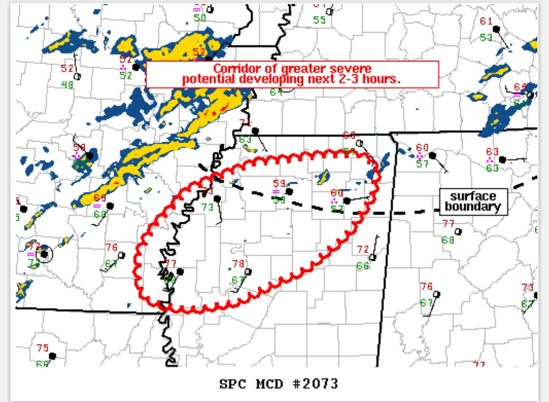
Mesoscale Discussion 2073 NWS Storm Prediction Center Norman OK 0118 PM CST Wed Dec 29 2021
Areas affected...extreme southeast AR into northern MS
Concerning...Tornado Watch 569...
Valid 291918Z - 292045Z
The severe weather threat for Tornado Watch 569 continues.
SUMMARY...The severe thunderstorms threat is expected to increase over the next couple of hours across northern MS.
DISCUSSION...GOES-16 1-minute data, specifically the cloud phase distinction RGB, has shown vertical development in TCU with beginnings of glaciation from near the Mississippi River in far northeast LA into north-central MS over the past 30 minutes. Should this trend continue and semi-discrete cells develop, a corridor of greater relative severe threat can be expected over the next 2-3 hours across the MCD area.
A surface boundary from morning convection extends from near Tunica, eastward across northern MS. To the south of this boundary, temperatures have warmed into the upper 70s with dewpoints in the upper 60s to near 70 F. This has resulted in rather quick destabilization with MLCAPE ranging from 500-1500 J/kg. Recent VWP data from KGWX shows a vertically veering wind profile with a somewhat small, but favorably curved low-level hodograph. Low-level shear is forecast to improve somewhat with time, resulting in slightly larger hodographs and a more favorable environment to support supercells capable of producing a few tornadoes this afternoon.
..Leitman.. 12/29/2021
...Please see www.spc.noaa.gov for graphic product...
ATTN...WFO...MEG...JAN...LZK...
LAT...LON 34479085 34678970 34708901 34618871 34318840 34128844 33798871 33438921 33208968 33198982 33119008 33089093 33199124 33349135 33609139 33799133 34129123 34339103 34479085

Posted on 12/29/21 at 2:04 pm to LegendInMyMind
The line is moving into the danger zone now, no warnings yet.
Posted on 12/29/21 at 2:16 pm to East Coast Band
Im so fricking cold yall.
Posted on 12/29/21 at 2:22 pm to Duke
quote:
Im so fricking cold yall.
This is uncalled for.
Posted on 12/29/21 at 2:39 pm to LegendInMyMind
Havent been above freezing in a week, currently 18 and this looks the warmest day until 2022.
Dont worry though, Im sending a couple of shipments down that way to start the year.
Though ought to produce some severe.
Dont worry though, Im sending a couple of shipments down that way to start the year.
Though ought to produce some severe.
This post was edited on 12/29/21 at 2:39 pm
Posted on 12/29/21 at 2:43 pm to Duke
quote:
Im so fricking cold yall.
Me too but that’s because I have the AC on and am running a fever due to covid and the SO took my blanket away I keep on the couch to wash it because it’s “covered in germs”
fricking bitch
Posted on 12/29/21 at 2:44 pm to East Coast Band
Update as of 2000Z
Day 1 Convective Outlook
NWS Storm Prediction Center Norman OK
0143 PM CST Wed Dec 29 2021
Valid 292000Z - 301200Z
...THERE IS AN ENHANCED RISK OF SEVERE THUNDERSTORMS OVER PORTIONS
OF EASTERN ARKANSAS...NORTHERN MISSISSIPPI...SOUTHERN
TENNESSEE...NORTHERN ALABAMA...AND NORTHWEST GEORGIA...
...SUMMARY...
Tornadoes, damaging thunderstorm gusts and isolated large hail are
possible from parts of the lower Mississippi Valley into the
Tennessee Valley and southern Appalachians vicinity through tonight.
...20Z Update...
Severe probabilities were compressed in parts of western Arkansas
and southeastern Oklahoma. The airmass behind current activity in
central/southeastern Arkansas has stabilized the airmass.
Thunderstorms in Arkansas and northern Louisiana will continue to
move eastward into a destabilizing airmass across central/northern
Mississippi. Please see MCD 2073 for more short-term details on this
region.
..Wendt.. 12/29/2021
This post was edited on 12/29/21 at 2:48 pm

 Page 3 of 7

Popular
Back to top