- My Forums
- Tiger Rant
- LSU Recruiting
- SEC Rant
- Saints Talk
- Pelicans Talk
- More Sports Board
- Fantasy Sports
- Golf Board
- Soccer Board
- O-T Lounge
- Tech Board
- Home/Garden Board
- Outdoor Board
- Health/Fitness Board
- Movie/TV Board
- Book Board
- Music Board
- Political Talk
- Money Talk
- Fark Board
- Gaming Board
- Travel Board
- Food/Drink Board
- Ticket Exchange
- TD Help Board
Customize My Forums- View All Forums
- Show Left Links
- Topic Sort Options
- Trending Topics
- Recent Topics
- Active Topics
Started By
Message
 2
2

Posted on 3/25/21 at 11:28 pm to rt3
quote:
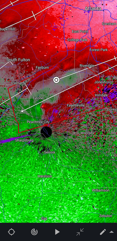
power out at NWS Peachtree City office
Who covers for them?

Posted on 3/25/21 at 11:29 pm to LegendInMyMind
quote:
Melissa Nord
@MelissaNordWx
Circulation is crossing between PTC and Tyrone -- moving ENE towards Fayetteville

Posted on 3/25/21 at 11:30 pm to LegendInMyMind
Couplet still showing through the clutter.
Posted on 3/25/21 at 11:30 pm to rt3
multiple reports of structural damage in Newnan
Posted on 3/25/21 at 11:31 pm to rt3
quote:
multiple reports of structural damage in Newnan
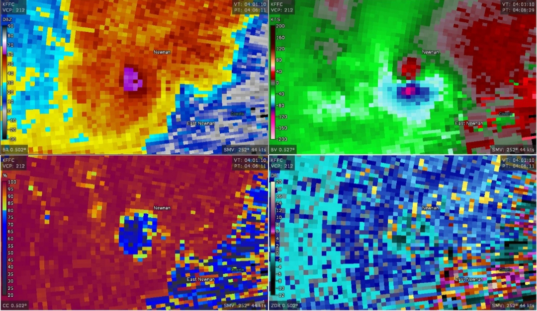
I believe it. TDS was strong when it passed.
Posted on 3/25/21 at 11:31 pm to Bobby OG Johnson
quote:
Matthew Cappucci
@MatthewCappucci
I can't believe I'm saying this, but Metro #Atlanta, especially in southern areas, could see some debris fall in the next 20 minutes.
It's from the #tornado that struck Newnan.
It's fanned out into the storm and been carried northeast by strong jet stream winds.

Posted on 3/25/21 at 11:32 pm to Bobby OG Johnson
quote:
It's fanned out into the storm and been carried northeast by strong jet stream winds.
We saw this some earlier with the Brent/Centreville tornado.
Posted on 3/25/21 at 11:36 pm to SM6
You okay?
Posted on 3/25/21 at 11:40 pm to hiremikeleach
Hopefully it is dying instead of cycling right now.
Posted on 3/25/21 at 11:43 pm to LegendInMyMind
They dropped the warning.
Posted on 3/25/21 at 11:44 pm to LegendInMyMind
quote:
Stu Ostro
@StuOstro
#Newnan #gawx


Posted on 3/25/21 at 11:47 pm to LegendInMyMind
Storm passed through, not a ton of damage here, leaves branches and a random siding on the ground. No hail with it. from the tracks you guys have posted it must have passed a mile or so to my north if it went between PTC and Tyrone. Got kinda hairy there for a bit.
Posted on 3/25/21 at 11:51 pm to Bobby OG Johnson
@ou_sam
quote:
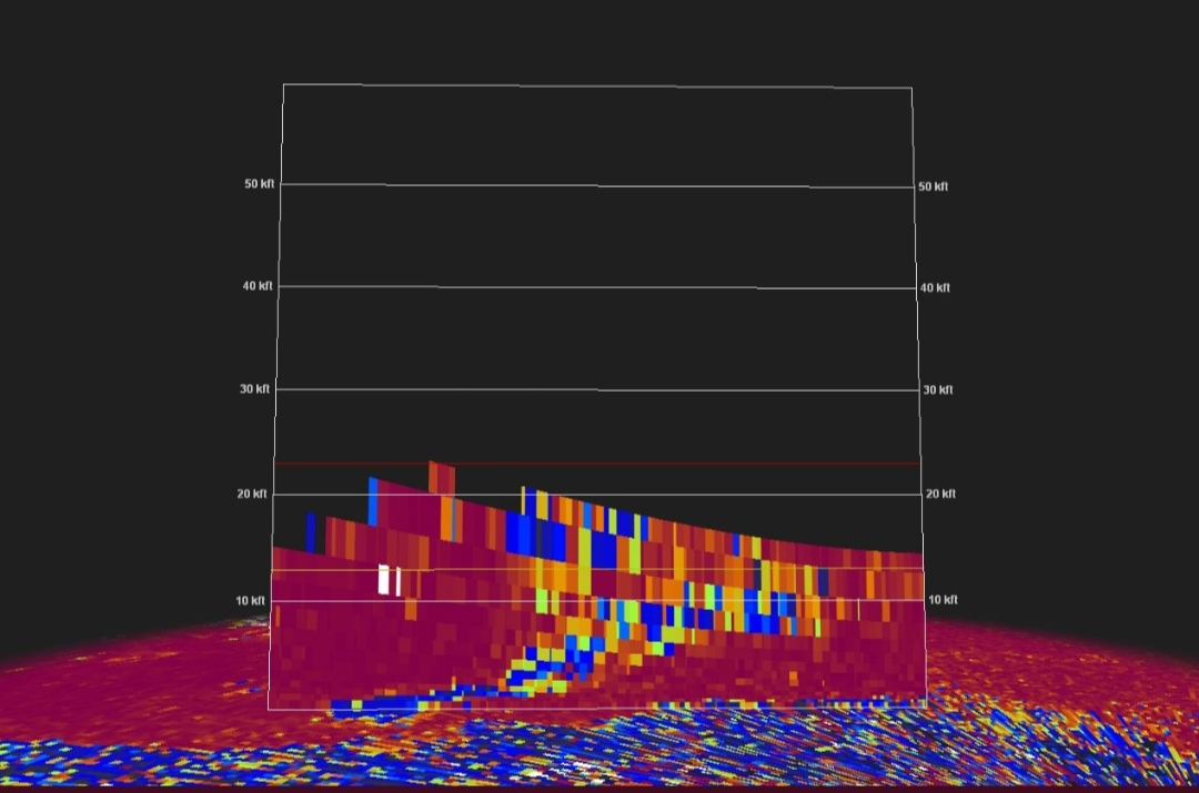
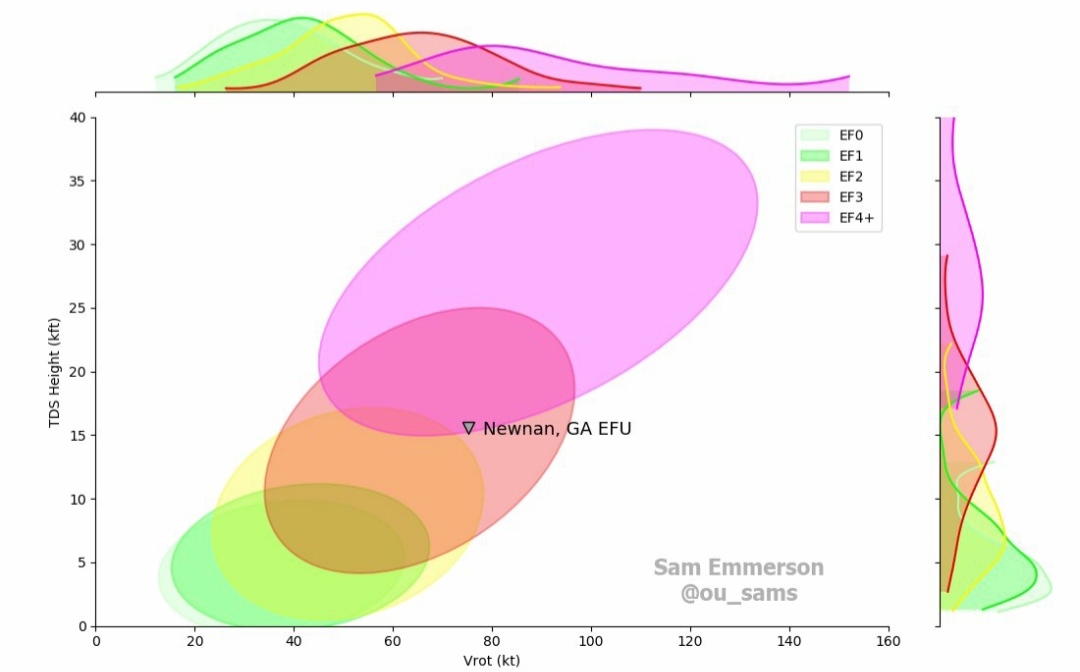
Life comes around full circle sometimes, right? The tornado that impacted Newnan and Peachtree City, GA (location of the WFO where I developed my TDS analysis methods) was likely in the EF3 range, based on a well-resolved 75 kt couplet and a TDS extending up to 15,000 feet. #gawx LINK
Posted on 3/26/21 at 12:01 am to LegendInMyMind
Ugh. That's not good. And a night too?
Hopefully this front weakens a bit before it reaches Columbia later today. I'm not encouraged though as it is much more humid tonight than it was last week when we were supposed to get severe weather (it didn't even rain).
Hopefully this front weakens a bit before it reaches Columbia later today. I'm not encouraged though as it is much more humid tonight than it was last week when we were supposed to get severe weather (it didn't even rain).
Posted on 3/26/21 at 12:13 am to jefffan
I just drove from Peachtree City to Tyrone where the storm should have passed through. Branches downed but nothing that looked too bad from the two major roadways. I wonder if the tornado was airborne when it passed through?
Posted on 3/26/21 at 12:18 am to SM6
quote:
I just drove from Peachtree City to Tyrone where the storm should have passed through. Branches downed but nothing that looked too bad from the two major roadways. I wonder if the tornado was airborne when it passed through?
It lifted.
I think when it really ramped up it might have pulled around some cooler air. Like a low pressure occluding. This would cause it to lift.

Posted on 3/26/21 at 6:33 am to Duke
Drone footage from Centerville, AL (currently a live video as of 6:30am CT):
Alabama Aerial Photography on Facebook
Alabama Aerial Photography on Facebook
Posted on 3/26/21 at 6:38 am to Roll Tide Ravens
So far I’ve heard of no deaths in Alabama from the monster tornado that impacted places like Brent, Centerville, Calera, Wilsonville, etc.
Posted on 3/26/21 at 8:02 am to Roll Tide Ravens

 Page 65 of 86

Popular
Back to top