- My Forums
- Tiger Rant
- LSU Recruiting
- SEC Rant
- Saints Talk
- Pelicans Talk
- More Sports Board
- Fantasy Sports
- Golf Board
- Soccer Board
- O-T Lounge
- Tech Board
- Home/Garden Board
- Outdoor Board
- Health/Fitness Board
- Movie/TV Board
- Book Board
- Music Board
- Political Talk
- Money Talk
- Fark Board
- Gaming Board
- Travel Board
- Food/Drink Board
- Ticket Exchange
- TD Help Board
Customize My Forums- View All Forums
- Show Left Links
- Topic Sort Options
- Trending Topics
- Recent Topics
- Active Topics
Started By
Message
re: UPDATE: Another Potential Severe Weather Event for the South (insert dates)
Posted on 3/25/21 at 9:13 pm to LegendInMyMind
Posted on 3/25/21 at 9:13 pm to LegendInMyMind
 1
1

Posted on 3/25/21 at 9:13 pm to LegendInMyMind
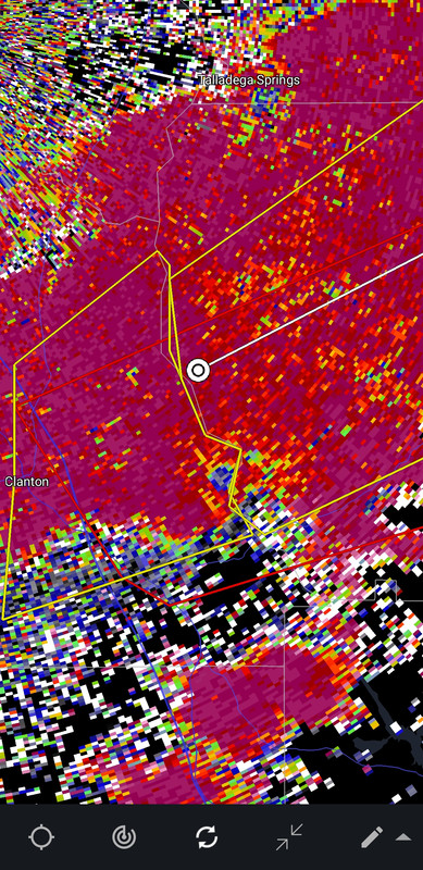
Man that is a beautiful super cell.
Posted on 3/25/21 at 9:14 pm to LegendInMyMind
Sigh. Crazy how they’ve all been in that 50 or so on mile swath.
I’m sure there is a meteorological reason, but it sucks nonetheless.
I’m sure there is a meteorological reason, but it sucks nonetheless.

Posted on 3/25/21 at 9:15 pm to CypressTrout10

Posted on 3/25/21 at 9:16 pm to slackster
There's been a quasi front from all the rain to the north hanging around all day. The long tracks have been rooting in that boundary and you enhance that low level inflow and spin.
At least that's what it has looked like to me today.
At least that's what it has looked like to me today.
Posted on 3/25/21 at 9:18 pm to Bobby OG Johnson
Well that was a weird reflectivity/velocity frame just now. Like it broadened out and closed it from the north.
Posted on 3/25/21 at 9:19 pm to Duke

Posted on 3/25/21 at 9:19 pm to slackster
quote:
Sigh. Crazy how they’ve all been in that 50 or so on mile swath.
This day/outbreak is going to get some serious research thrown at it. There's a whole lot going on that even top-notch mets aren't understanding right now. One of the main ones is, why no development farther north? Nothing is even trying to get going when it does pop up (not that I am complaining). It is odd how the setup played out.
Posted on 3/25/21 at 9:20 pm to Duke
This tornado just plowed straight through Lake Mitchell. My dad lived on Lake Mitchell for about 10 years up until a few years ago. He still has some friends that live there. Quite a few nice houses on that lake.
This post was edited on 3/25/21 at 9:21 pm
Posted on 3/25/21 at 9:21 pm to Duke
quote:
There's been a quasi front from all the rain to the north hanging around all day. The long tracks have been rooting in that boundary and you enhance that low level inflow and spin.
That's a big part of it. The storm motion of this front coming into North AL is another. It is more aligned with the shear. Models didn't pick that up.
Also, the storms firing earlier than expected over central AL had an impact on the whole day.
This post was edited on 3/25/21 at 9:25 pm
Posted on 3/25/21 at 9:24 pm to LegendInMyMind
quote:
why no development farther north? Nothing is even trying to get going when it does pop up (not that I am complaining). It is odd how the setup played out.
I said that meaning North AL, not forgetting the warnings in southern TN. Even they have been mostly embedded.
Posted on 3/25/21 at 9:24 pm to Bobby OG Johnson
quote:
Due to concerns with an area of storms moving into Marshall and DeKalb Counties, we have added those counties back into the Tornado Watch. #HUNwx

Posted on 3/25/21 at 9:26 pm to Bobby OG Johnson

Posted on 3/25/21 at 9:26 pm to Bobby OG Johnson
quote:
Due to concerns with an area of storms moving into Marshall and DeKalb Counties, we have added those counties back into the Tornado Watch. #HUNwx
Saw that. Local mets questioned NWS Huntsville leaving them out to start with with those storms still to their south.
Posted on 3/25/21 at 9:29 pm to Bobby OG Johnson
Just west of Rockford, AL tornado on ground
Severe Weather Statement
National Weather Service Birmingham AL
922 PM CDT Thu Mar 25 2021
ALC037-260300-
/O.CON.KBMX.TO.W.0066.000000T0000Z-210326T0300Z/
Coosa AL-
922 PM CDT Thu Mar 25 2021
...A TORNADO WARNING REMAINS IN EFFECT UNTIL 1000 PM CDT FOR EASTERN
COOSA COUNTY...
]At 922 PM CDT, a confirmed tornado was located over Lyle, or near
Rockford, moving northeast at 45 mph.
HAZARD...Damaging tornado.
SOURCE...Radar confirmed tornado.
IMPACT...Flying debris will be dangerous to those caught without
shelter. Mobile homes will be damaged or destroyed. Damage
to roofs, windows, and vehicles will occur. Tree damage is
likely.
Locations impacted include...
Goodwater, Rockford, Kellyton, Hanover, Lyle, Bradford, Moriah,
Hatchet, Crewsville, Bentleyville, Hissop and Ray.
PRECAUTIONARY/PREPAREDNESS ACTIONS...
To repeat, a tornado is on the ground. TAKE COVER NOW! Move to a
basement or an interior room on the lowest floor of a sturdy
building. Avoid windows. If you are outdoors, in a mobile home, or in
a vehicle, move to the closest substantial shelter and protect
yourself from flying debris.
Posted on 3/25/21 at 9:31 pm to Duke
quote:
Duke
This most recent supercell blew up and faded in 30 minutes. Debris signature and all. Is that partially because of the forward speed? Seems around 55mph.
If not, how does speed impact development, if at all.
Posted on 3/25/21 at 9:35 pm to slackster
Is this the longest thread ever on the OT?
Posted on 3/25/21 at 9:36 pm to NorthEndZone
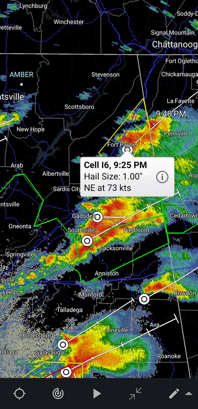
73 knots on that storm....wow.
Posted on 3/25/21 at 9:37 pm to tgrbaitn08
Posted on 3/25/21 at 9:37 pm to tgrbaitn08
quote:
Is this the longest thread ever on the OT?
Yep.

 Page 61 of 86

Popular
Back to top