- My Forums
- Tiger Rant
- LSU Recruiting
- SEC Rant
- Saints Talk
- Pelicans Talk
- More Sports Board
- Fantasy Sports
- Golf Board
- Soccer Board
- O-T Lounge
- Tech Board
- Home/Garden Board
- Outdoor Board
- Health/Fitness Board
- Movie/TV Board
- Book Board
- Music Board
- Political Talk
- Money Talk
- Fark Board
- Gaming Board
- Travel Board
- Food/Drink Board
- Ticket Exchange
- TD Help Board
Customize My Forums- View All Forums
- Show Left Links
- Topic Sort Options
- Trending Topics
- Recent Topics
- Active Topics
Started By
Message
re: UPDATE: Another Potential Severe Weather Event for the South (insert dates)
Posted on 3/23/21 at 8:27 am to tgrbaitn08

Posted on 3/23/21 at 8:27 am to tgrbaitn08
 3
3

Posted on 3/23/21 at 8:37 am to MorbidTheClown
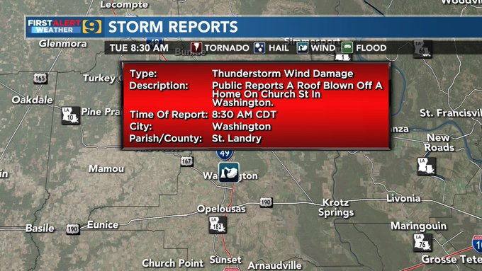
I’m in that triangle at my daddy’s in Goudeau. Getting hammered.
Posted on 3/23/21 at 8:39 am to MorbidTheClown
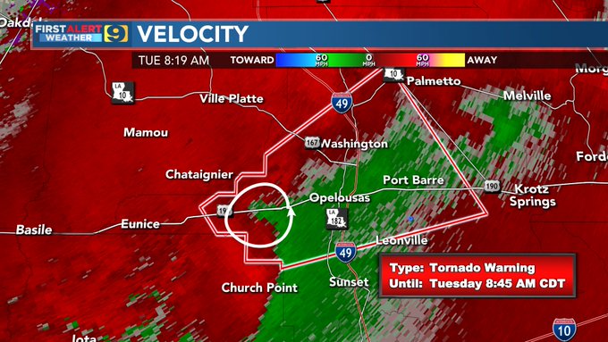
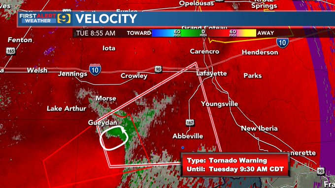
Tornado Warning
LAC023-113-231400-
/O.NEW.KLCH.TO.W.0004.210323T1324Z-210323T1400Z/
BULLETIN - EAS ACTIVATION REQUESTED
Tornado Warning
National Weather Service Lake Charles LA
824 AM CDT Tue Mar 23 2021
The National Weather Service in Lake Charles has issued a
* Tornado Warning for...
East central Cameron Parish in southwestern Louisiana...
Northwestern Vermilion Parish in southwestern Louisiana...
* Until 900 AM CDT.
* At 823 AM CDT, a severe thunderstorm capable of producing a tornado
was located 11 miles north of Rockefeller Wildlife Range, moving
northeast at 40 mph.
HAZARD...Tornado.
SOURCE...Radar indicated rotation.
IMPACT...Flying debris will be dangerous to those caught without
shelter. Mobile homes will be damaged or destroyed.
Damage to roofs, windows, and vehicles will occur. Tree
damage is likely.
* This dangerous storm will be near...
Gueydan around 850 AM CDT.
Wright around 855 AM CDT.
Other locations impacted by this tornadic thunderstorm include
Florence Landing.
Posted on 3/23/21 at 8:44 am to MorbidTheClown
Damn well I was supposed to go to New Iberia today. I guess that isn’t happening now
Posted on 3/23/21 at 8:47 am to tgrbaitn08
bawpaw and fam trailer gonna be rockin in church point
Posted on 3/23/21 at 8:53 am to Roll Tide Ravens
quote:
I know you don’t believe in most severe weather events, OP, but it’d be cool if you would give this thread a proper severe weather thread title.
Done...only bc you asked nicely.
Posted on 3/23/21 at 9:00 am to tgrbaitn08

Posted on 3/23/21 at 9:01 am to tgrbaitn08
quote:
Done...only bc you asked nicely.
Thank you, I hereby apologize for the rudeness of my last post.
Posted on 3/23/21 at 9:02 am to Roll Tide Ravens
It looks like some Harry Potter shite to the west of Lafayette. I expect the dark Lord to come down any moment now.
Posted on 3/23/21 at 9:02 am to Roll Tide Ravens
Posted on 3/23/21 at 9:07 am to Roll Tide Ravens
quote:
Thank you, I hereby apologize for the rudeness of my last post.
I didnt find it rude at all....you were very polite. Thank you and be safe

Posted on 3/23/21 at 9:09 am to LSUAngelHere1
quote:
Goudeau
Family is from Big Cane. Stay safe
Posted on 3/23/21 at 9:17 am to Teufelhunden

Posted on 3/23/21 at 9:17 am to Teufelhunden
My aunt and uncle owned the only grocery store in Big Cane for decades.
Posted on 3/23/21 at 9:19 am to MorbidTheClown
That looks more like straight MFing line winds than a tornado

Posted on 3/23/21 at 9:20 am to The Boat
Yea, it looks like a mini bow echo.
Disclaimer: my only weather experience are these threads.
Disclaimer: my only weather experience are these threads.
Posted on 3/23/21 at 9:26 am to Baers Foot
I dunno what it is except it’s heading this way.
Posted on 3/23/21 at 9:37 am to SATNIGHTS
As far as Thursday across MS and AL, there are basically two schools of thought: (1) there is the GFS scenario which provides a much narrower window for severe weather, keeping the threat limited to storms forming along the cold front; (2) there is the Euro scenario, which paints a potentially volatile setup with a large warm sector and a strong low-level jet which would allow supercells to flourish (if the system can avoid having too much convection like we had last week). It seems like the knowledgeable folks are leaning toward the Euro scenario and don’t really trust how the GFS is showing things.
This post was edited on 3/23/21 at 9:39 am
Posted on 3/23/21 at 9:43 am to SATNIGHTS
quote:
I dunno what it is except it’s heading this way.
WHICH way???

Posted on 3/23/21 at 9:45 am to TDTOM
quote:
It looks like some Harry Potter shite to the west of Lafayette. I expect the dark Lord to come down any moment now.

 Page 4 of 86

Popular
Back to top