- My Forums
- Tiger Rant
- LSU Recruiting
- SEC Rant
- Saints Talk
- Pelicans Talk
- More Sports Board
- Coaching Changes
- Fantasy Sports
- Golf Board
- Soccer Board
- O-T Lounge
- Tech Board
- Home/Garden Board
- Outdoor Board
- Health/Fitness Board
- Movie/TV Board
- Book Board
- Music Board
- Political Talk
- Money Talk
- Fark Board
- Gaming Board
- Travel Board
- Food/Drink Board
- Ticket Exchange
- TD Help Board
Customize My Forums- View All Forums
- Show Left Links
- Topic Sort Options
- Trending Topics
- Recent Topics
- Active Topics
Started By
Message
re: UPDATE: Another Potential Severe Weather Event for the South (insert dates)
Posted on 3/24/21 at 5:59 pm to tgrbaitn08

Posted on 3/24/21 at 5:59 pm to tgrbaitn08
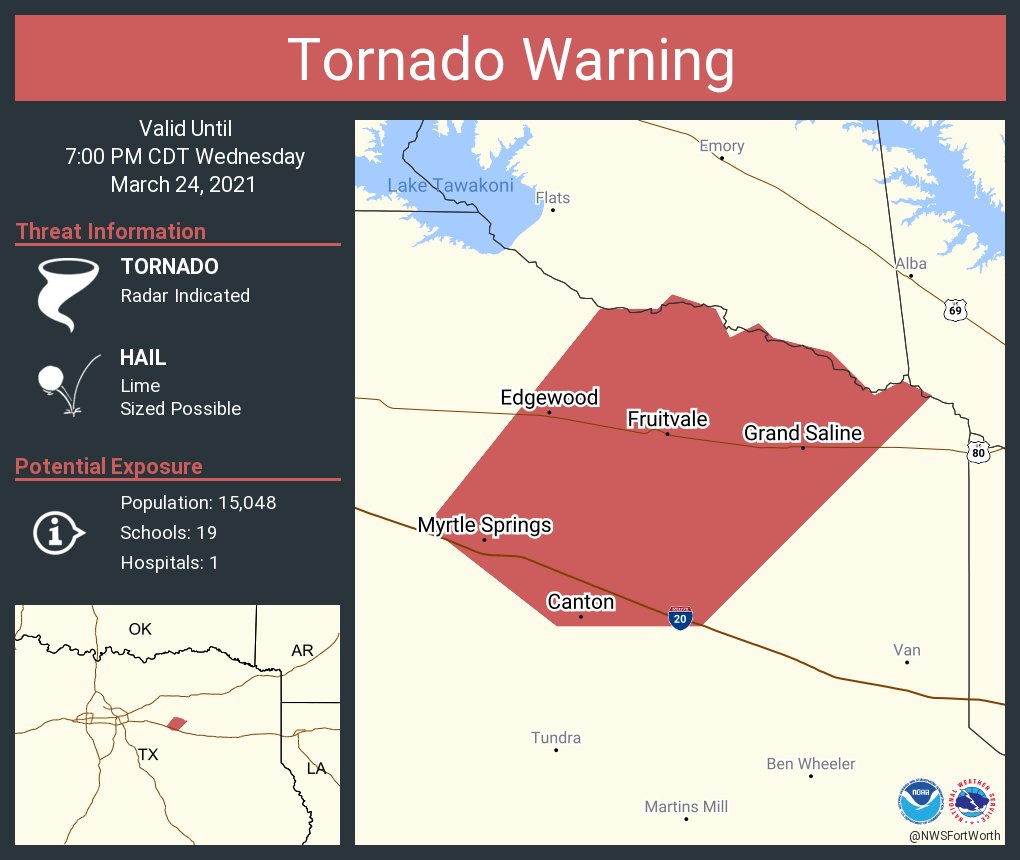
Forney, Canton, Myrtle Springs, look the hell outside rotations for everyone
 0
0


Posted on 3/24/21 at 6:01 pm to LegendInMyMind
Extreme SW Frisco, TX
Posted on 3/24/21 at 6:04 pm to LSUGrrrl
quote:
Extreme SW Frisco, TX
It will be close for these storms. If the track meet is outdoors I would expect lightning delays. Also, there's no way to tell exactly what will develop.
Posted on 3/24/21 at 6:06 pm to LegendInMyMind
That storm near Heartland looks to have a hook, but isn't spinning much right now.
Posted on 3/24/21 at 6:06 pm to LegendInMyMind
It’s outdoors and already going. My son runs the last event so we show up just for that. It would be best if it started before we needed to be there but the timing it setting up to hit right on us. Would prefer to not be stuck outside or in my car when that line hits.
Posted on 3/24/21 at 6:07 pm to LegendInMyMind
Canton storm is gigantic hailer.
I have direct view of KDFW and theres on cell that aint much on radar right now SW of the airport but visually its pretty impressive.
I have direct view of KDFW and theres on cell that aint much on radar right now SW of the airport but visually its pretty impressive.
Posted on 3/24/21 at 6:09 pm to 50_Tiger
quote:
I have direct view of KDFW and theres on cell that aint much on radar right now SW of the airport but visually its pretty impressive.
Hell, its rotation looks better than the warned storm right now.
Nevermind, the warned storm is looking better right now.
This post was edited on 3/24/21 at 6:11 pm
Posted on 3/24/21 at 6:11 pm to LegendInMyMind
quote:
Hell, its rotation looks better than the warned storm right now.
Nevermind, the warned storm is looking better right now.
Hahah yeah I need the Airport Cell to die as its pointing really close to my vicinity
Canton cell still very broad rotation
This post was edited on 3/24/21 at 6:12 pm

Posted on 3/24/21 at 6:12 pm to rds dc
quote:
I started to post something no that spike but figured most wouldn't get the joke
This is the OT weather board. If someone doesn’t get a weather joke they should go hang out with PJ
Posted on 3/24/21 at 6:13 pm to 50_Tiger
quote:
Canton cell still very broad rotation
Looking better, though. I bet it gets warned soonish.
Posted on 3/24/21 at 6:15 pm to LegendInMyMind
quote:
Looking better, though. I bet it gets warned soonish.
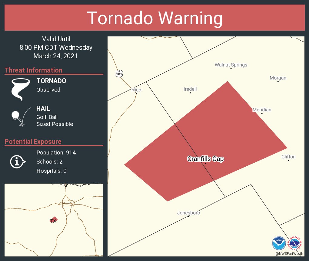
Probably as velo suggests its about to move right through west canton
Posted on 3/24/21 at 6:17 pm to 50_Tiger
Canton cell is supercell AF on reflectivity
Posted on 3/24/21 at 6:19 pm to The Boat
quote:
Canton cell is supercell AF on reflectivity
It has had that look for a little while now. Not good when you see purple. Better have your helmet.
Posted on 3/24/21 at 6:26 pm to LegendInMyMind
Im noticing on radar that a lot of the cells further west seem to have their convection being blown off on radar. Even HRRR run keeps most of the bad stuff in the vicinity its moving over/through now.
Posted on 3/24/21 at 6:31 pm to 50_Tiger
Posted on 3/24/21 at 6:35 pm to deltaland
quote:
deltaland
After reading your 30 or so post on the weather thread last week, I’m thinking maybe you take a little while off in these threads. LOL

Posted on 3/24/21 at 6:45 pm to tgrbaitn08
Posted on 3/24/21 at 7:10 pm to LegendInMyMind

 Page 12 of 86

Popular
Back to top