




- My Forums
- Tiger Rant
- LSU Recruiting
- SEC Rant
- Saints Talk
- Pelicans Talk
- More Sports Board
- Fantasy Sports
- Golf Board
- Soccer Board
- O-T Lounge
- Tech Board
- Home/Garden Board
- Outdoor Board
- Health/Fitness Board
- Movie/TV Board
- Book Board
- Music Board
- Political Talk
- Money Talk
- Fark Board
- Gaming Board
- Travel Board
- Food/Drink Board
- Ticket Exchange
- TD Help Board
Customize My Forums- View All Forums
- Show Left Links
- Topic Sort Options
- Trending Topics
- Recent Topics
- Active Topics
Started By
Message

Tornado Thread: Plain States (Moderate Risk and PDS Tornado Watch)
Posted on 5/16/17 at 2:14 pm


Posted on 5/16/17 at 2:14 pm
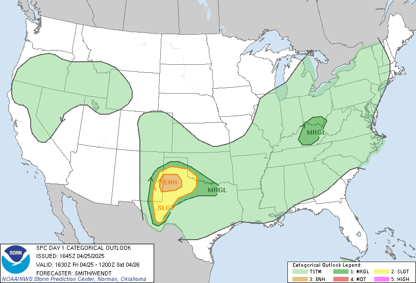
Day 1 Convective Outlook, Moderate risk in parts of Oklahoma and Texas, with a large enhanced risk area, as well:
PDS (Particularly Dangerously Situation) Tornado Watch:

URGENT - IMMEDIATE BROADCAST REQUESTED
Tornado Watch Number 220
NWS Storm Prediction Center Norman OK
150 PM CDT Tue May 16 2017
The NWS Storm Prediction Center has issued a
* Tornado Watch for portions of
Western Oklahoma
Eastern Texas Panhandle
* Effective this Tuesday afternoon and evening from 150 PM until
1000 PM CDT.
...THIS IS A PARTICULARLY DANGEROUS SITUATION...
* Primary threats include...
Several tornadoes and a few intense tornadoes likely
Widespread large hail and isolated very large hail events to 4
inches in diameter likely
Scattered damaging winds likely with isolated significant gusts
to 75 mph possible
SUMMARY...Isolated supercell thunderstorms are expected to form
along the dryline over the eastern Texas Panhandle and track across
the watch area this afternoon and evening. Very large hail and
isolated strong tornadoes are possible in this area.
The tornado watch area is approximately along and 55 statute miles
east and west of a line from 75 miles south southwest of Childress
TX to 55 miles north northwest of Gage OK. For a complete depiction
of the watch see the associated watch outline update (WOUS64 KWNS
WOU0).
PRECAUTIONARY/PREPAREDNESS ACTIONS...
REMEMBER...A Tornado Watch means conditions are favorable for
tornadoes and severe thunderstorms in and close to the watch
area. Persons in these areas should be on the lookout for
threatening weather conditions and listen for later statements
and possible warnings.
&&
PDS (Particularly Dangerously Situation) Tornado Watch:
URGENT - IMMEDIATE BROADCAST REQUESTED
Tornado Watch Number 220
NWS Storm Prediction Center Norman OK
150 PM CDT Tue May 16 2017
The NWS Storm Prediction Center has issued a
* Tornado Watch for portions of
Western Oklahoma
Eastern Texas Panhandle
* Effective this Tuesday afternoon and evening from 150 PM until
1000 PM CDT.
...THIS IS A PARTICULARLY DANGEROUS SITUATION...
* Primary threats include...
Several tornadoes and a few intense tornadoes likely
Widespread large hail and isolated very large hail events to 4
inches in diameter likely
Scattered damaging winds likely with isolated significant gusts
to 75 mph possible
SUMMARY...Isolated supercell thunderstorms are expected to form
along the dryline over the eastern Texas Panhandle and track across
the watch area this afternoon and evening. Very large hail and
isolated strong tornadoes are possible in this area.
The tornado watch area is approximately along and 55 statute miles
east and west of a line from 75 miles south southwest of Childress
TX to 55 miles north northwest of Gage OK. For a complete depiction
of the watch see the associated watch outline update (WOUS64 KWNS
WOU0).
PRECAUTIONARY/PREPAREDNESS ACTIONS...
REMEMBER...A Tornado Watch means conditions are favorable for
tornadoes and severe thunderstorms in and close to the watch
area. Persons in these areas should be on the lookout for
threatening weather conditions and listen for later statements
and possible warnings.
&&
This post was edited on 5/16/17 at 2:16 pm
 4
4


Posted on 5/16/17 at 2:15 pm to Roll Tide Ravens
Awesome, this means we will get a shitstorm in 30-40 hours!
Posted on 5/16/17 at 2:16 pm to Roll Tide Ravens
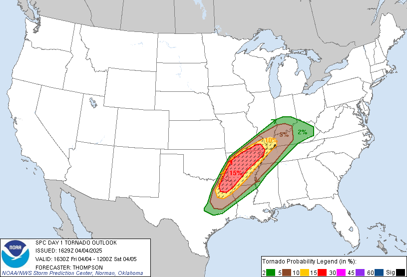
Tornado probabilities, 15% hatched area:
Posted on 5/16/17 at 2:18 pm to HempHead
Depends on where you are, if you're in the southeast, an upper ridge will send this system north of that area. That's how it is this time of year. May is the core of severe weather season for the area under the gun today.
Posted on 5/16/17 at 3:45 pm to Roll Tide Ravens
Several tornado warnings out now.

Posted on 5/16/17 at 4:05 pm to Roll Tide Ravens
Impressive parameters in place over great viewing terrain, would be a good day to chase.

Posted on 5/16/17 at 4:45 pm to rds dc
Live tornado on TWC now.


Posted on 5/16/17 at 5:04 pm to rds dc
They're entertaining to watch when they're on the plains and not a threat to humans

Posted on 5/16/17 at 5:05 pm to ForeverLSU02
Getting dark off to the horizon

Posted on 5/16/17 at 5:26 pm to Roll Tide Ravens
Correct.
Posted on 5/16/17 at 5:40 pm to dukke v
quote:
Correct.
Oh shite. We're in for it now.
Posted on 5/16/17 at 5:42 pm to Jim Rockford
Sitting on my porch in KC...been windy as hell here today

Posted on 5/16/17 at 6:03 pm to Shotgun Willie
Work sent me here to Oklahoma city.. it's windy as hell
Posted on 5/16/17 at 6:09 pm to Roll Tide Ravens
Just got back from Lubbock...was quiet down that way. Light drizzle as we entered Wichita Falls. Think our show is late night/early morning hours

 Page 1 of 1


Popular
Back to top
 Follow TigerDroppings for LSU Football News