




- My Forums
- Tiger Rant
- LSU Recruiting
- SEC Rant
- Saints Talk
- Pelicans Talk
- More Sports Board
- Fantasy Sports
- Golf Board
- Soccer Board
- O-T Lounge
- Tech Board
- Home/Garden Board
- Outdoor Board
- Health/Fitness Board
- Movie/TV Board
- Book Board
- Music Board
- Political Talk
- Money Talk
- Fark Board
- Gaming Board
- Travel Board
- Food/Drink Board
- Ticket Exchange
- TD Help Board
Customize My Forums- View All Forums
- Show Left Links
- Topic Sort Options
- Trending Topics
- Recent Topics
- Active Topics
Started By
Message
re: Tornado! Rampaging Tri-State TX-LA-MS - Threat Continues Overnight
Posted on 4/23/20 at 2:53 am to bayoubengals88
Posted on 4/23/20 at 2:53 am to bayoubengals88
quote:
Look like the worst of it could hit between Zachary and St. Francisville.
Thinking that too. Welp no more sleep for me tonight.
 3
3


Posted on 4/23/20 at 2:55 am to titmouse
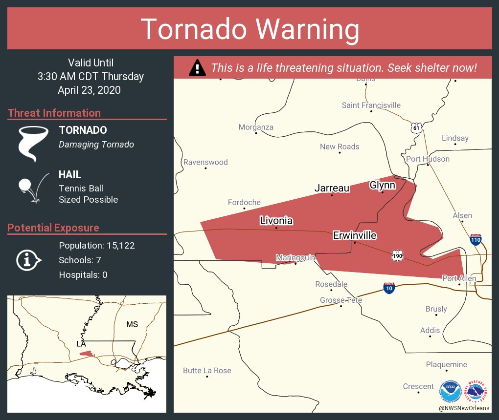
Posted on 4/23/20 at 2:56 am to lsuman25
It's right on top of 190. Livonia in the cross hairs soon.
Posted on 4/23/20 at 2:56 am to Athletix
The radar due west of Livonia is showing extremely intense activity. Could be debris. Could be hail.

Posted on 4/23/20 at 2:56 am to titmouse
The hail hitting this house is unreal loud. It’s past us now and there’s a lull. Baws I ain’t lying there’s a rumbling. Thunder maybe. Got the family and a newborn in a tub in the inner most room of the house. Scared as frick

Posted on 4/23/20 at 2:57 am to titmouse
Holy shite. I missed the TENNIS BALL sized hail alert!!!

Posted on 4/23/20 at 2:57 am to rds dc
NBR about to get fuuucked
Posted on 4/23/20 at 2:58 am to Athletix
Where are you Athletix?
Posted on 4/23/20 at 2:58 am to bayoubengals88
Livonia. Right off 190 south
Posted on 4/23/20 at 3:01 am to Athletix
Please check in when it’s past you. Keep ‘Em safe!

Posted on 4/23/20 at 3:02 am to rds dc
velocity couplet went away as of right now
Posted on 4/23/20 at 3:02 am to Athletix
Jesus. Y’all need to get real small and cover yourselves if you aren’t already. Stay safe.
Posted on 4/23/20 at 3:03 am to DVinBR
All quiet here now. No wind, rain... just the sound of distant thunder
Posted on 4/23/20 at 3:05 am to Athletix
Might be the most intense/fear driven 10 minutes of my life. Prayers for those in its path.
Posted on 4/23/20 at 3:06 am to rds dc
676
WUUS54 KLIX 230803
SVRLIX
LAC033-037-063-091-230900-
/O.NEW.KLIX.SV.W.0046.200423T0803Z-200423T0900Z/
BULLETIN - EAS ACTIVATION REQUESTED
Severe Thunderstorm Warning
National Weather Service New Orleans LA
303 AM CDT Thu Apr 23 2020
The National Weather Service in New Orleans has issued a
* Severe Thunderstorm Warning for...
Southern St. Helena Parish in southeastern Louisiana...
Livingston Parish in southeastern Louisiana...
Southern East Feliciana Parish in southeastern Louisiana...
East Baton Rouge Parish in southeastern Louisiana...
* Until 400 AM CDT.
* At 302 AM CDT, a severe thunderstorm was located near Erwinville,
or 11 miles west of Port Allen, moving east at 50 mph.
HAZARD...Two inch hail and 70 mph wind gusts.
SOURCE...Radar indicated.
IMPACT...People and animals outdoors will be injured. Expect hail
damage to roofs, siding, windows, and vehicles. Expect
considerable tree damage. Wind damage is also likely to
mobile homes, roofs, and outbuildings.
* Locations impacted include...
Baton Rouge, Zachary, Baker, Denham Springs, Port Allen,
Greensburg, Oak Hills Place, Walker, Livingston, French Settlement,
Albany, Slaughter, Port Vincent, Montpelier, Westminster, Watson,
Pride, Shenandoah, Greenwell Spring and Old Jefferson.
PRECAUTIONARY/PREPAREDNESS ACTIONS...
A Tornado Watch remains in effect until 500 AM CDT for southeastern
Louisiana.
For your protection move to an interior room on the lowest floor of a
building.
WUUS54 KLIX 230803
SVRLIX
LAC033-037-063-091-230900-
/O.NEW.KLIX.SV.W.0046.200423T0803Z-200423T0900Z/
BULLETIN - EAS ACTIVATION REQUESTED
Severe Thunderstorm Warning
National Weather Service New Orleans LA
303 AM CDT Thu Apr 23 2020
The National Weather Service in New Orleans has issued a
* Severe Thunderstorm Warning for...
Southern St. Helena Parish in southeastern Louisiana...
Livingston Parish in southeastern Louisiana...
Southern East Feliciana Parish in southeastern Louisiana...
East Baton Rouge Parish in southeastern Louisiana...
* Until 400 AM CDT.
* At 302 AM CDT, a severe thunderstorm was located near Erwinville,
or 11 miles west of Port Allen, moving east at 50 mph.
HAZARD...Two inch hail
and 70 mph wind gusts. SOURCE...Radar indicated.
IMPACT...People and animals outdoors will be injured. Expect hail
damage to roofs, siding, windows, and vehicles. Expect
considerable tree damage. Wind damage is also likely to
mobile homes, roofs, and outbuildings.
* Locations impacted include...
Baton Rouge, Zachary, Baker, Denham Springs, Port Allen,
Greensburg, Oak Hills Place, Walker, Livingston, French Settlement,
Albany, Slaughter, Port Vincent, Montpelier, Westminster, Watson,
Pride, Shenandoah, Greenwell Spring and Old Jefferson.
PRECAUTIONARY/PREPAREDNESS ACTIONS...
A Tornado Watch remains in effect until 500 AM CDT for southeastern
Louisiana.
For your protection move to an interior room on the lowest floor of a
building.
Posted on 4/23/20 at 3:07 am to Athletix
Thankful y’all are safe. Go see how big the hail is lol
Posted on 4/23/20 at 3:08 am to DVinBR
Worried about trees and hail.

Posted on 4/23/20 at 3:10 am to bayoubengals88
Just pulled my truck inside the warehouse at work. Don’t need any hail damage
Posted on 4/23/20 at 3:10 am to bayoubengals88
That storm has to be moving 70 or 80 mph.
Posted on 4/23/20 at 3:11 am to rds dc

that purple in there

 Page 32 of 43

Popular
Back to top
 Follow TigerDroppings for LSU Football News