- My Forums
- Tiger Rant
- LSU Recruiting
- SEC Rant
- Saints Talk
- Pelicans Talk
- More Sports Board
- Fantasy Sports
- Golf Board
- Soccer Board
- O-T Lounge
- Tech Board
- Home/Garden Board
- Outdoor Board
- Health/Fitness Board
- Movie/TV Board
- Book Board
- Music Board
- Political Talk
- Money Talk
- Fark Board
- Gaming Board
- Travel Board
- Food/Drink Board
- Ticket Exchange
- TD Help Board
Customize My Forums- View All Forums
- Show Left Links
- Topic Sort Options
- Trending Topics
- Recent Topics
- Active Topics
Started By
Message
 1
1


Posted on 12/13/22 at 3:34 pm to TH03
This should make for a fun commute home to Desoto Parish at 5pm

Posted on 12/13/22 at 3:35 pm to Large Farva
Storms won't hit new orleans until overnight into tomorrow.

Posted on 12/13/22 at 3:37 pm to TH03
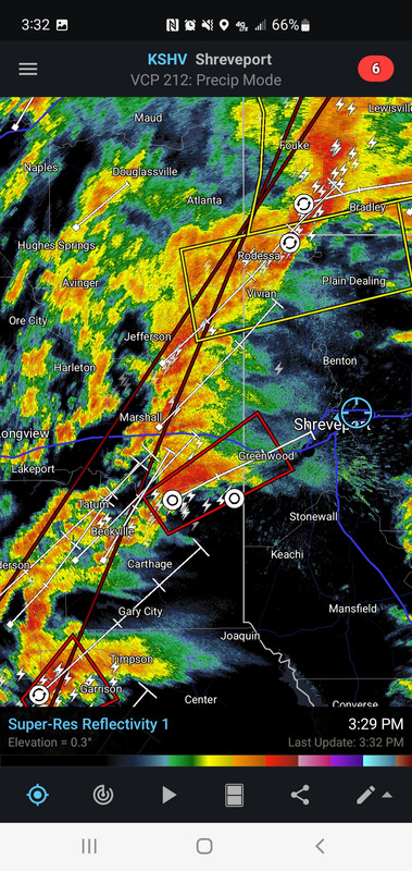
What was the Carthage cell now heading towards Waskom might have a tornado on the ground
Eta: Definitely on the ground

Eta: Definitely on the ground
This post was edited on 12/13/22 at 3:41 pm
Posted on 12/13/22 at 3:40 pm to The Boat
I don't think that one is a might.
Posted on 12/13/22 at 3:42 pm to LegendInMyMind
Confirmed tornado on the ground headed into Caddo. May clip northern Shreveport
Reports of a large Wedge on the ground south of Elysian fields
Reports of a large Wedge on the ground south of Elysian fields
This post was edited on 12/13/22 at 3:43 pm
Posted on 12/13/22 at 3:43 pm to LegendInMyMind
It was just a CC blip when I said that... next scan was clear.
It's heading right for the I-20 Texas welcome center
It's heading right for the I-20 Texas welcome center
Posted on 12/13/22 at 3:43 pm to LegendInMyMind
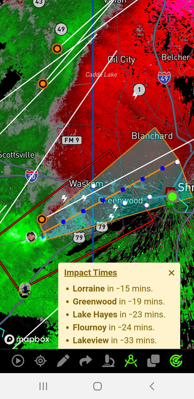
NWS: observed tornado on the ground headed towards Greenwood and might cross I-20 during peak afternoon drive time
Posted on 12/13/22 at 3:44 pm to The Boat
If that supercell printer to the south has a merger or two we will have another just like these two in a bit.
Posted on 12/13/22 at 3:46 pm to LegendInMyMind
Oh wow it's lit up like a Christmas tree on velocity
Posted on 12/13/22 at 3:48 pm to LegendInMyMind
Cell heading towards Greenwood/Shreveport is bad news.
Posted on 12/13/22 at 3:50 pm to rds dc
If that one keeps up, the local news sky cams might get some good shots as it moves in
Posted on 12/13/22 at 3:50 pm to rds dc
Brad Arnold just drove damn near through that fricker if his location is right.
Posted on 12/13/22 at 3:50 pm to rds dc
I'm not expert, but it looks pretty textbook to me. Just a nasty SOB
Posted on 12/13/22 at 3:52 pm to rt3
quote:
Meteorologist Nick Mikulas
It’s radar watching time, and I’m not loving what I’m seeing. First off, storms are becoming more scattered as they weaken along the cold front, and develop in the open warm sector. This lack of competition between storms is allowing for cells that are barely even producing lightning to exhibit moderate to strong rotation. There have already been at least a couple reports of tornados in Texas, and will likely be several more across Texas, Louisiana, Arkansas, and Mississippi before this system exits. Another problem I’m seeing is sunshine peeking through south of the warm front. That’s allowing temperatures to warm a couple degrees higher than models have been forecasting. This means more instability, and a greater risk for severe weather. Because of all these factors, SPC has issued a tornado watch for a large part of the area until 10:00 PM. It’s possible this will be expanded to other areas, and extended further into the night as storms slowly move across the area. If you aren’t in a watch now, it’s totally possible, and even likely that you will be later. I’ll be watching things closely, but can never guarantee I’ll get every warning posted. Fortunately, there are 700 different ways to get them. I will likely bust out the live stream set up later, but always just let things develop as the day/night progresses. It looks like a bumpy 12 hours or so.

Posted on 12/13/22 at 3:53 pm to rt3
quote:
First off, storms are becoming more scattered as they weaken along the cold front, and develop in the open warm sector.
Score one for the HRRR.

Posted on 12/13/22 at 3:53 pm to rt3
What happen to the Christmas day Armageddon reference?!
Posted on 12/13/22 at 3:54 pm to Oates Mustache
Are those tornado sirens on Timmers stream? fricking eerie as shite
Posted on 12/13/22 at 3:54 pm to LegendInMyMind
This one is heading right through the Texas welcome center. There will be a ton of videos of this one and hopefully everyone is ready. I'm sure there's truckers sleeping in their rig right now.

 Page 29 of 108

Popular
Back to top