- My Forums
- Tiger Rant
- LSU Recruiting
- SEC Rant
- Saints Talk
- Pelicans Talk
- More Sports Board
- Coaching Changes
- Fantasy Sports
- Golf Board
- Soccer Board
- O-T Lounge
- Tech Board
- Home/Garden Board
- Outdoor Board
- Health/Fitness Board
- Movie/TV Board
- Book Board
- Music Board
- Political Talk
- Money Talk
- Fark Board
- Gaming Board
- Travel Board
- Food/Drink Board
- Ticket Exchange
- TD Help Board
Customize My Forums- View All Forums
- Show Left Links
- Topic Sort Options
- Trending Topics
- Recent Topics
- Active Topics
Started By
Message
re: Tornado! Outbreak Underway New PDS Watch for South LA, MS, & AL
Posted on 12/12/22 at 9:46 pm to jdd48

Posted on 12/12/22 at 9:46 pm to jdd48
quote:
Jay Grymes going to say again on air again that there's absolutely 0% chance of snow?
And he’ll be blocking people on his Facebook page for calling him out on it. Like the piss poor little bitch that he is.
 0
0


Posted on 12/12/22 at 9:47 pm to rds dc
Sheeeit
Posted on 12/12/22 at 9:52 pm to USMCguy121
So BR getting snow Christmas Day? Saw something on another weather FB page about this.
Posted on 12/12/22 at 9:54 pm to LSUGrrrl
We have a 5% risk for our area...overnight into early morning, assuming I am reading NOAA'S SPC properly
Posted on 12/12/22 at 9:56 pm to wfallstiger
Posted on 12/12/22 at 10:08 pm to tigafan4life
quote:
So BR getting snow Christmas Day? Saw something on another weather FB page about this.
Yep! Probably 8"-17".
Posted on 12/12/22 at 10:14 pm to LegendInMyMind
quote:
Meteorologist Nick Mikulas
Evening update time. Central and Northern Louisiana remain squarely in the main threat zone for severe weather from Tuesday afternoon through Tuesday night. So no real change there. I’ll attach the updated SPC graphics, which are similar to what I posted this morning. Severe weather could start as soon as 2:00 PM Tuesday, with the most active timeframe from 6:00 PM until 3:00 AM. The one change I’ve seen is that at least scattered rain should hang around for most of the area through Wednesday morning as a second disturbance moves through the area. This could actually hold a severe threat through 9:00 AM Wednesday for Avoyelles and St. Landry Parish. I’ll keep an eye on that tomorrow, but the main point here is that we have a level 3 of 5, enhanced risk for severe weather from Tuesday afternoon through most of Tuesday night. After that giant hurdle, we get to enjoy some cooler weather, and hopefully start talking about some winter potential. I’ll post an update in the morning.


Posted on 12/12/22 at 10:22 pm to rt3
Tornado watches already popping off in panhandle and OK

This post was edited on 12/12/22 at 10:23 pm
Posted on 12/12/22 at 10:25 pm to Strannix
Two warned storms also

Posted on 12/12/22 at 11:11 pm to trussthetruzz
This is going to be a really potent upper level low. This cold front moves east all the way through Florida with severe chances moving east all the way through Friday morning. The Plains tonight, Texas and Lousiana Tuesday, the Gulf Coast from Louisiana to Alabama Wednesday, and Florida Thursday.
Oxford comma check in thread.
Oxford comma check in thread.
Posted on 12/12/22 at 11:22 pm to The Boat
I think it has big boom or bust chances as far as tornadoes go. I feel better about it performing tonight than I have at any time leading up to it, though. For a pure trough ejection it has a lot of potential.
This post was edited on 12/12/22 at 11:30 pm
Posted on 12/12/22 at 11:29 pm to LegendInMyMind
quote:
as somebody who has experienced -25 with wind chills of -40+
I have been in these conditions. It’s amazing. Every bit of moisture the leaves you - breathe, spit, snot - immediately freezes. Mustache becomes a block of ice.
Posted on 12/13/22 at 12:07 am to BPTiger

Posted on 12/13/22 at 12:12 am to BPTiger
One Weather app shows nothing below freezing thru Dec 21.
Posted on 12/13/22 at 12:41 am to lsuman25
Enhanced area keeps expanding southward. Not surprising.
Posted on 12/13/22 at 12:51 am to The Boat
Local news in Br tonight made it sound like heavy rain (4-5”) and wind is our primary concern for the severe threat. Tornado/hail chances increasing?
Posted on 12/13/22 at 1:41 am to trussthetruzz
 Tuesday
 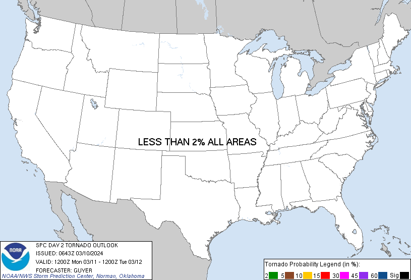 Wednesday Tornado probs
Posted on 12/13/22 at 2:36 am to The Boat
Downvote for Oxford comma. It’s like saying “and and”. Redundant waste of punctuation artifacts, unsightly and useless.
Should have been called the Ole Miss comma because it’s useless.
Should have been called the Ole Miss comma because it’s useless.
quote:
Oxford comma check in thread.
Posted on 12/13/22 at 3:54 am to lsuman25
Front coming through here now, radar warned tornado about 20 miles due south [am in Wichita Falls].
Ya'll stay vigilant today as this rascal just might be a stout one.
Ya'll stay vigilant today as this rascal just might be a stout one.

Posted on 12/13/22 at 4:37 am to jimmy the leg
In Ponchatoula? Yes absolutely, I can remember a handful of times that it has gotten into the single digits and it was always bone dry. Only time I can ever remember any kind wet stuff was I think 81 or 82. I got up to go school and it was like 6-7 degrees. The next night it rained and there was ice everywhere. Missed school the whole week. Last time I can remember single digits was in the early / mid 90’s when it got to like 4-5 degrees. None of these events happens while there was snow on the ground.
This post was edited on 12/13/22 at 4:55 am

 Page 17 of 108

Popular
Back to top