- My Forums
- Tiger Rant
- LSU Score Board
- LSU Recruiting
- SEC Rant
- SEC Score Board
- Saints Talk
- Pelicans Talk
- More Sports Board
- Coaching Changes
- Fantasy Sports
- Golf Board
- Soccer Board
- O-T Lounge
- Tech Board
- Home/Garden Board
- Outdoor Board
- Health/Fitness Board
- Movie/TV Board
- Book Board
- Music Board
- Political Talk
- Money Talk
- Fark Board
- Gaming Board
- Travel Board
- Food/Drink Board
- Ticket Exchange
- TD Help Board
Customize My Forums- View All Forums
- Show Left Links
- Topic Sort Options
- Trending Topics
- Recent Topics
- Active Topics
Started By
Message

 1
1


Posted on 12/15/21 at 1:31 pm to Briella
Some fast movers.
The wind is absolutely whipping in OKC right now.
The wind is absolutely whipping in OKC right now.

Posted on 12/15/21 at 1:34 pm to okietiger


Posted on 12/15/21 at 1:51 pm to Roll Tide Ravens
Tornado warnings already popping off in Nebraska.
Posted on 12/15/21 at 2:00 pm to HogX
Tornado on the ground in Hanson, NE.
Posted on 12/15/21 at 2:05 pm to Roll Tide Ravens
Probabilities within the tornado watch:
Tornadoes
Probability of 2 or more tornadoes High (70%)
Probability of 1 or more strong (EF2-EF5) tornadoes Mod (40%)
Wind
Probability of 10 or more severe wind events High (90%)
Probability of 1 or more wind events > 65 knots High (70%)
Tornadoes
Probability of 2 or more tornadoes High (70%)
Probability of 1 or more strong (EF2-EF5) tornadoes Mod (40%)
Wind
Probability of 10 or more severe wind events High (90%)
Probability of 1 or more wind events > 65 knots High (70%)
This post was edited on 12/15/21 at 2:06 pm
Posted on 12/15/21 at 2:07 pm to Roll Tide Ravens
quote:
Probabilities within the tornado watch:
Tornadoes
Probability of 2 or more tornadoes High (70%)
Probability of 1 or more strong (EF2-EF5) tornadoes Mod (40%)
Wind
Probability of 10 or more severe wind events High (90%)
Probability of 1 or more wind events > 65 knots High (70%)
and for those who don't feel like mathing today... 65 knots is approximately 75 mph
Posted on 12/15/21 at 2:21 pm to rt3
Better chase in a Tesla...that's well charged.
Posted on 12/15/21 at 2:30 pm to okietiger
quote:
NWS Louisville @NWSLouisville
NWS survey team confirms at least EF-1 #tornado damage in Green County, with max wind speeds at least 95 mph. The survey is ongoing, and it is not yet known whether this is a continuous path with Hart or Taylor Counties. #kywx
Posted on 12/15/21 at 3:06 pm to rt3
Things already looking rough with this line as it moves through Nebraska.

This post was edited on 12/15/21 at 3:06 pm
Posted on 12/15/21 at 3:08 pm to rt3
quote:
and for those who don't feel like mathing today... 65 knots is approximately 75 mph
Top Fuel storm chasing.
This post was edited on 12/15/21 at 3:14 pm
Posted on 12/15/21 at 3:13 pm to LegendInMyMind
Chase the appex of that line. Best bet may be to post up in Sioux City and let them come to you.

Posted on 12/15/21 at 3:27 pm to LegendInMyMind
Interesting CC drop along a gust front in the line:
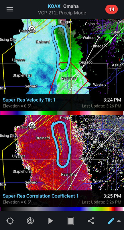
Posted on 12/15/21 at 3:30 pm to LegendInMyMind
man, that's very interesting.
What the hell am i looking at?
What the hell am i looking at?
Posted on 12/15/21 at 3:40 pm to Chad504boy
quote:
man, that's very interesting.
What the hell am i looking at?
very strong straight line winds that could be doing damage on the ground
Posted on 12/15/21 at 3:40 pm to Chad504boy
Generally blue means it’s picking up non weather phenomena, so in this case not being associated with a tornado would indicate debris from straight line winds.
Posted on 12/15/21 at 3:40 pm to Chad504boy
The area circled is high wind. In the bottom image the dark blue is some sort of debris being kicked up, probably dust and lighter vegetation.
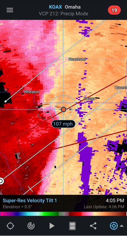
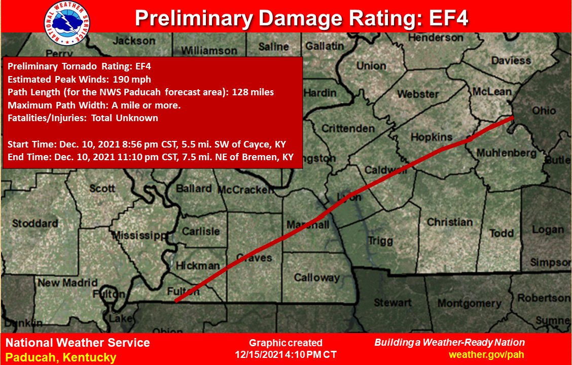
Posted on 12/15/21 at 4:21 pm to LegendInMyMind
Preliminary rating on the Mayfield tornado.
Posted on 12/15/21 at 4:22 pm to LegendInMyMind
It started out as a few pixels of 100mph+. Now, there are more with the highest I've seen being 112mph.

 Page 85 of 90

Popular
Back to top