- My Forums
- Tiger Rant
- LSU Recruiting
- SEC Rant
- SEC Score Board
- Saints Talk
- Pelicans Talk
- More Sports Board
- Coaching Changes
- Fantasy Sports
- Golf Board
- Soccer Board
- O-T Lounge
- Tech Board
- Home/Garden Board
- Outdoor Board
- Health/Fitness Board
- Movie/TV Board
- Book Board
- Music Board
- Political Talk
- Money Talk
- Fark Board
- Gaming Board
- Travel Board
- Food/Drink Board
- Ticket Exchange
- TD Help Board
Customize My Forums- View All Forums
- Show Left Links
- Topic Sort Options
- Trending Topics
- Recent Topics
- Active Topics
Started By
Message
re: Tornado outbreak, 94 dead, Upwards of 100 unaccounted for search/rescue & cleanup ongoing
Posted on 12/10/21 at 7:41 pm to LegendInMyMind

Posted on 12/10/21 at 7:41 pm to LegendInMyMind
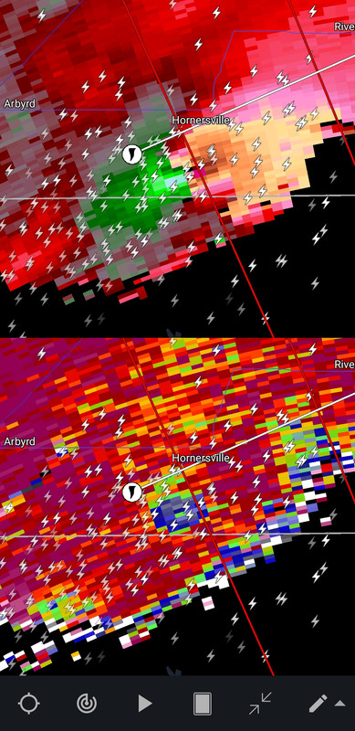
Can someone check newport real quick.
Thanks.
Thanks.
 2
2

Posted on 12/10/21 at 7:41 pm to blzr
quote:
Nothingburger idiot
Wut
I never said this system was a nothingburger. I said earlier on today I thought this would exceed expectations.
Posted on 12/10/21 at 7:42 pm to deltaland
quote:
deltaland
Your folks are getting some pretty big winds right now.
Posted on 12/10/21 at 7:42 pm to Rebel
quote:
So far nothing in Memphis.
There's a bit of a cap (keeps storms from rising up) and that has kept Memphis clean thus far because without it, things look very tornadoy.
Posted on 12/10/21 at 7:43 pm to pioneerbasketball
quote:
Can someone check newport real quick.
What's the closest city?

Posted on 12/10/21 at 7:43 pm to LegendInMyMind
quote:
Brandon Payne
@brandonwxal
MAJOR STRUCTURAL DAMAGE IN MONETTE
@NWSMemphis

Posted on 12/10/21 at 7:43 pm to deltaland

Posted on 12/10/21 at 7:43 pm to LegendInMyMind
Newport/Batesville/tuckerman/newark
Posted on 12/10/21 at 7:44 pm to Bobby OG Johnson

quote:
Mesoscale Discussion 1992
NWS Storm Prediction Center Norman OK
0741 PM CST Fri Dec 10 2021
Areas affected...Northeast Arkansas...southern Missouri...northwest
Tennessee...and southwest Kentucky.
Concerning...Tornado Watch 552...
Valid 110141Z - 110245Z
The severe weather threat for Tornado Watch 552 continues.
SUMMARY...A strong to potentially violent tornado is ongoing in far
northeastern Arkansas and is expected to persist.
DISCUSSION...A mature and very strong supercell in northeast
Arkansas is currently producing a very strong to potentially violent
tornado. The downstream airmass remains very favorable with
dewpoints near 70, strengthening/backing surface flow, and 0-1 km
SRH in excess of 400 m2/s2 per KNQA VWP. This is yielding STP around
5. Given the favorable downstream environment with no convection to
disrupt this storm, expect the significant tornado threat to
continue for at least a few more hours as this discrete, long-track
supercell continues northeast.
..Bentley/Grams.. 12/11/2021
Posted on 12/10/21 at 7:45 pm to LegendInMyMind
K8 reporting ef3/ef4?
Posted on 12/10/21 at 7:45 pm to pioneerbasketball
quote:
Can someone check newport real quick
Will get a warning soon, think theres a weak tornado in there.
Posted on 12/10/21 at 7:45 pm to Rebel
quote:
So far nothing in Memphis. Just a little windy and very very warm.
Memphis and north half of Ms gonna get it later after 9-10pm. It’s not to us just yet
Posted on 12/10/21 at 7:46 pm to Duke
All flatland
Posted on 12/10/21 at 7:46 pm to LegendInMyMind
quote:
Your folks are getting some pretty big winds right now.
Grandmother texting me they just missed the winds. Lost power. My uncle is getting slammed though he lives northwest of them. But he has a large 2 story house that’s well built
Posted on 12/10/21 at 7:46 pm to pioneerbasketball
quote:
K8 reporting ef3/ef4?
No one actually knows the rating and true strength of the tornado until the NWS can do their surveys in the days to come.
Posted on 12/10/21 at 7:47 pm to pioneerbasketball
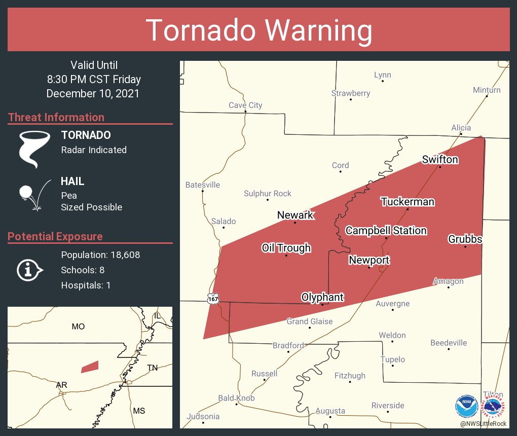
quote:
Newport/Batesville/tuckerman/newark
Batesville is clear at the moment.
quote:
There's a suspect area that isn't warned near Pleasant Plainst headed Northeast.
Ans it was just warned. I'll post a shot of it.
This post was edited on 12/10/21 at 7:49 pm

Posted on 12/10/21 at 7:48 pm to Roll Tide Ravens
quote:
No one actually knows the rating and true strength of the tornado until the NWS can do their surveys in the days to come.
True, but with radar you can get a good estimate. See my post on the previous page.
Posted on 12/10/21 at 7:48 pm to Duke
Do you expect the cap to lift or hold in place?
Posted on 12/10/21 at 7:48 pm to LegendInMyMind

 Page 17 of 90

Popular
Back to top