- My Forums
- Tiger Rant
- LSU Score Board
- LSU Recruiting
- SEC Rant
- SEC Score Board
- Saints Talk
- Pelicans Talk
- More Sports Board
- Coaching Changes
- Fantasy Sports
- Golf Board
- Soccer Board
- O-T Lounge
- Tech Board
- Home/Garden Board
- Outdoor Board
- Health/Fitness Board
- Movie/TV Board
- Book Board
- Music Board
- Political Talk
- Money Talk
- Fark Board
- Gaming Board
- Travel Board
- Food/Drink Board
- Ticket Exchange
- TD Help Board
Customize My Forums- View All Forums
- Show Left Links
- Topic Sort Options
- Trending Topics
- Recent Topics
- Active Topics
Started By
Message
re: Tornado outbreak, 94 dead, Upwards of 100 unaccounted for search/rescue & cleanup ongoing
Posted on 12/10/21 at 7:14 pm to pioneerbasketball

Posted on 12/10/21 at 7:14 pm to pioneerbasketball
Gum point take cover
 0
0


Posted on 12/10/21 at 7:15 pm to Duke
quote:
I am very lazy.
Me too that is why I pull the images from twitters
quote:
Mesoscale Discussion 1988
NWS Storm Prediction Center Norman OK
0702 PM CST Fri Dec 10 2021
Areas affected...Eastern Missouri and western Illinois
Concerning...Tornado Watch 553...
Valid 110102Z - 110200Z
The severe weather threat for Tornado Watch 553 continues.
SUMMARY...The damaging wind and tornado threat is increasing across
eastern Missouri and western Illinois, including the St. Louis Metro
area.
DISCUSSION...A line of storms has organized across central Missouri
and is moving quickly east toward the Mississippi River. Within this
line are several embedded supercells with some low-level rotation
evident from the KLSX WSR-88D. The storm with the coldest cloud tops
is currently moving toward St. Louis. Therefore, this portion of the
line in particular may have a greater severe wind/tornado threat
over the next 1 to 2 hours, especially given the backed surface flow
and around 500 m2/s2 0-1 km SRH from the KLSX VWP.
..Bentley.. 12/11/2021
Posted on 12/10/21 at 7:16 pm to Bobby OG Johnson
Twin tornados

Posted on 12/10/21 at 7:16 pm to Bobby OG Johnson
Jonesboro tornado

Posted on 12/10/21 at 7:16 pm to Bobby OG Johnson
quote:
Spotter Network Inc
@spotternetwork
Spotr 3 miles NNE of GREENFIELD, AR @ 01:11 UTC Damage>-Power lines down, structure damage at this location
Posted on 12/10/21 at 7:16 pm to Duke
quote:
Sure as hell a potent environment right now, as evidence by *points at radar*
Since I don’t understand those maps can you explain exactly how large the potent environment area is?
Posted on 12/10/21 at 7:17 pm to deltaland
Lake city just lost power
Posted on 12/10/21 at 7:18 pm to pioneerbasketball
Bic just cancelled game.
Sent people home.
Sent people home.
Posted on 12/10/21 at 7:19 pm to pioneerbasketball
quote:
Lake city just lost power
Something got took out just to the North of them.
Posted on 12/10/21 at 7:19 pm to LegendInMyMind
Blytheville sirens going off.

Posted on 12/10/21 at 7:19 pm to pioneerbasketball

Posted on 12/10/21 at 7:19 pm to Bobby OG Johnson
Continued

Posted on 12/10/21 at 7:20 pm to Bobby OG Johnson
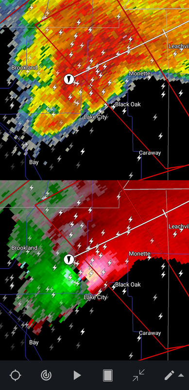
Monette about to get hammered
Posted on 12/10/21 at 7:20 pm to Roll Tide Ravens
The inflow notch on that storm is legit.
Posted on 12/10/21 at 7:21 pm to Bobby OG Johnson
Well, even if you hit like 30% of the time, it's better for me. 


Little Rock sounding from this evening.
That's going to be a hard no for me, thanks.
No surprise the Jonesboro tornado has been doing what it has, since that's what that image implies would be happening.
Little Rock sounding from this evening.
That's going to be a hard no for me, thanks.
No surprise the Jonesboro tornado has been doing what it has, since that's what that image implies would be happening.
Posted on 12/10/21 at 7:21 pm to Roll Tide Ravens
I don’t have the pro version. Can you post that same look for the storm west of Beebe? It’s wrapping a hook and headed directly for my grandparents mobile home west of Beebe
Is there a couplet or debris signature on that one?
Is there a couplet or debris signature on that one?
Posted on 12/10/21 at 7:22 pm to deltaland
Injuries reported in Greenville
Posted on 12/10/21 at 7:23 pm to pioneerbasketball
Possom grape 8:01

 Page 14 of 90

Popular
Back to top