- My Forums
- Tiger Rant
- LSU Recruiting
- SEC Rant
- Saints Talk
- Pelicans Talk
- More Sports Board
- Fantasy Sports
- Golf Board
- Soccer Board
- O-T Lounge
- Tech Board
- Home/Garden Board
- Outdoor Board
- Health/Fitness Board
- Movie/TV Board
- Book Board
- Music Board
- Political Talk
- Money Talk
- Fark Board
- Gaming Board
- Travel Board
- Food/Drink Board
- Ticket Exchange
- TD Help Board
Customize My Forums- View All Forums
- Show Left Links
- Topic Sort Options
- Trending Topics
- Recent Topics
- Active Topics
Started By
Message
 1
1


Posted on 11/29/22 at 4:05 pm to LegendInMyMind
quote:
New warning up in near Olla, LA. Let's see if it gets going.
That cell just got a speeding ticket
Posted on 11/29/22 at 4:07 pm to LegendInMyMind
Natchitoches cell could be a problem. It has that look and nothing around it to hamper it
Posted on 11/29/22 at 4:10 pm to deltaland
All those cells in west Louisiana could be a problem later if they don’t form into a QLCS
Posted on 11/29/22 at 4:32 pm to deltaland
quote:
NWS Shreveport @NWSShreveport
Tornado Warning including Natchitoches LA, Natchez LA and Saint Maurice LA until 5:15 PM CST

Posted on 11/29/22 at 4:32 pm to rt3
that cell by Olla looking red bean-y
Posted on 11/29/22 at 4:36 pm to rt3
Back to back couplets heading just to the north of Yazoo City
Posted on 11/29/22 at 4:39 pm to The Boat
The 2nd one is looking nasty
ETA and could go right through town
ETA and could go right through town
This post was edited on 11/29/22 at 4:46 pm
Posted on 11/29/22 at 4:46 pm to The Boat
Yep. Near dark and shite is starting to crank.
Posted on 11/29/22 at 4:57 pm to LegendInMyMind
quote:
NWS Shreveport @NWSShreveport
Tornado Warning including Zwolle LA, Milam TX and Negreet LA until 5:45 PM CST

Posted on 11/29/22 at 5:00 pm to rt3
Damn that tornado conveyor belt from Toledo Bend to Yazoo City.
This post was edited on 11/29/22 at 5:01 pm
Posted on 11/29/22 at 5:11 pm to The Boat
One by bass field, ms does not look good on radar
Posted on 11/29/22 at 5:13 pm to The Boat
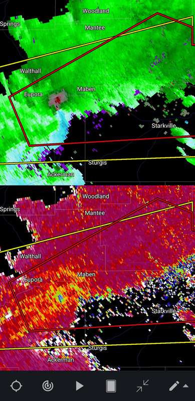
The Eupora, NW of Starkville storm has what may be a BWER. Best looking couplet I've seen today.
Hell, everything is looking better than it has all day.
Hell, everything is looking better than it has all day.
This post was edited on 11/29/22 at 5:16 pm
Posted on 11/29/22 at 5:16 pm to The Boat
The one SW of Bernice, LA looks good on rdaar but isn't warned yet.
Posted on 11/29/22 at 5:18 pm to Crisprdestroyer
quote:
One by bass field, ms does not look good on radar
Of course.
Posted on 11/29/22 at 5:18 pm to rt3
Local Mets seeing debris on the one coming from sabine Texas into sabine parish la.
This post was edited on 11/29/22 at 5:19 pm
Posted on 11/29/22 at 5:18 pm to NorthEndZone
On the ground SE of Eupora.
Posted on 11/29/22 at 5:18 pm to NorthEndZone
Im in Vicksburg, about to get serious here?

 Page 13 of 21

Popular
Back to top