- My Forums
- Tiger Rant
- LSU Recruiting
- SEC Rant
- Saints Talk
- Pelicans Talk
- More Sports Board
- Fantasy Sports
- Golf Board
- Soccer Board
- O-T Lounge
- Tech Board
- Home/Garden Board
- Outdoor Board
- Health/Fitness Board
- Movie/TV Board
- Book Board
- Music Board
- Political Talk
- Money Talk
- Fark Board
- Gaming Board
- Travel Board
- Food/Drink Board
- Ticket Exchange
- TD Help Board
Customize My Forums- View All Forums
- Show Left Links
- Topic Sort Options
- Trending Topics
- Recent Topics
- Active Topics
Started By
Message
 1
1


Posted on 8/12/16 at 10:22 pm to MrSmith
This is at Amite River bridge on hwy 432. The cow was under water for 15-20 seconds while going under the bridge. Was surprised to see it pop back up.


Posted on 8/12/16 at 10:25 pm to MrSmith
Yeah

Posted on 8/12/16 at 10:25 pm to PawnMaster
Woah
Posted on 8/12/16 at 10:26 pm to GEAUXmedic
Thanks. I remember using that site when I got my flood insurance but I don't know much else 

Posted on 8/12/16 at 10:33 pm to MrSmith
Talked to some relatives in Central that have never flooded that have a foot of water in their house.
Posted on 8/12/16 at 10:33 pm to Bushmaster
Flood insurance?
Posted on 8/12/16 at 10:34 pm to GEAUXmedic
Appreciate any other links to follow river stages, flood plans, and timelines and what they all mean.I live between Jones Creek and Stumberg(a part that's never flooded) but I feel like all bets are off.
Posted on 8/12/16 at 10:36 pm to MrSmith
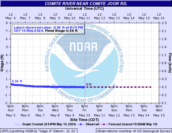
Crest of 4 feet higher than 1953 record of the Comite tomorrow...Has already topped the April 1983 level. 500 year flood...Unless you are over 70, you have never seen anything like this. Secure your valuables and seek higher ground if you are in the flood zone.
33 500-year flood.
30.64 Highest stage on record, May 19, 1953.
30 There will be widespread major flooding.
25 Subdivisions between the Comite River and Beaver Bayou will have moderate flooding. High water will prevent recreational and industrial activity from Louisiana Highway 64 downstream to the Amite River junction. Farm animals and equipment should be moved to higher ground.
Posted on 8/12/16 at 10:38 pm to MrSmith
4 of 5 houses did. All family living next to each other.
Posted on 8/12/16 at 10:43 pm to Bushmaster
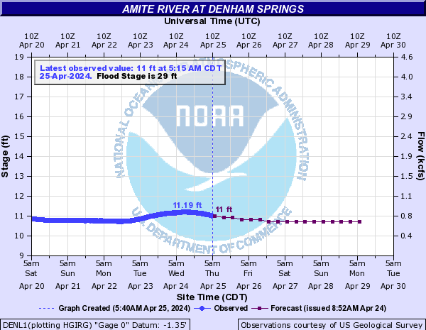
Amite River at Denham Springs...
41.5 The river will reach the record flood of April 1983. Widespread flooding of the area between Range Avenue in Denham Springs west to Airline Highway in Baton Rouge is expected.
39 Widespread major flooding can be expected in subdivisions along Tiger Bend Road, Antioch Road, Eliot Road, and in Woodcrest and Stevendale Estates in Old Jefferson.
35 There will be moderate flooding of areas around Clay Cut Bayou, Jones Creek, and Honey Cut Bayou. In Denham Springs the area west of Florida Avenue will be subject to flooding.
30 Flooding will begin in the westernmost parts of Denham Springs. River Road at the foot of Benton Lane will flood.
Posted on 8/12/16 at 10:43 pm to NorthEndZone
This is all so sad. I think a lot of people that are new to this whole flooding thing are still in for a shock. What we have seen today is just childs play for what is to come Sunday and Monday in this whole area. The rivers cresting levels are almost unbelievable.
Posted on 8/12/16 at 10:44 pm to riseandgrind
Can anyone post a link to the 500 year flood map and what exactly would it take to hit such an event? How much more rain?
This post was edited on 8/12/16 at 10:46 pm
Posted on 8/12/16 at 10:49 pm to NorthEndZone
quote:
Secure your valuables and seek higher ground if you are in the flood zone.
I'm in the flood zone in the old Jefferson area but there's no real flooding at all in my subdivision
Posted on 8/12/16 at 10:50 pm to BigB0882
If everything I'm gathering is accurate, because this event is a 500 year flood...anything flooded on the 100 year map WILL flood in the coming days, correct?
Posted on 8/12/16 at 10:51 pm to MrSmith
All of the flooding currently is due to rainwater piling up in streets and not draining fast enough.
The real threat is the Amite flooding sometime tomorrow, which could be catastrophic.
(Take this FWIW, I am not an expert. Just what I've picked up from reading GulfcoastWX.)
The real threat is the Amite flooding sometime tomorrow, which could be catastrophic.
(Take this FWIW, I am not an expert. Just what I've picked up from reading GulfcoastWX.)
Posted on 8/12/16 at 10:52 pm to LSUsmartass
quote:No. The map isn't exact science. And changes are always taking place. It was 2012 since it was released and even longer when some places were evaluated. Subdivisions being built, taking down timber, let it grow. Way too many variables and things changing to say "everything in these large areas will definitely flood."
anything flooded on the 100 year map WILL flood in the coming days, correct?
Posted on 8/12/16 at 10:53 pm to ParkerTiger7
quote:Starting tomorrow. Sunday night will likely be the worst.
The real threat is the Amite flooding sometime tomorrow, which could be catastrophic.
Posted on 8/12/16 at 10:56 pm to ell_13
It's is pouring in Central right now fml...
Posted on 8/12/16 at 10:57 pm to MrSmith
I'm just generalizing the threat and talking more about the Joor Road / Greenwell Springs Road area much farther north of you.
Denham Springs is a different story. It's still got about 10 feet more to rise before cresting.
Denham Springs is a different story. It's still got about 10 feet more to rise before cresting.

 Page 34 of 472

Popular
Back to top