- My Forums
- Tiger Rant
- LSU Recruiting
- SEC Rant
- Saints Talk
- Pelicans Talk
- More Sports Board
- Fantasy Sports
- Golf Board
- Soccer Board
- O-T Lounge
- Tech Board
- Home/Garden Board
- Outdoor Board
- Health/Fitness Board
- Movie/TV Board
- Book Board
- Music Board
- Political Talk
- Money Talk
- Fark Board
- Gaming Board
- Travel Board
- Food/Drink Board
- Ticket Exchange
- TD Help Board
Customize My Forums- View All Forums
- Show Left Links
- Topic Sort Options
- Trending Topics
- Recent Topics
- Active Topics
Started By
Message
re: SW LA getting rocked by severe storms this morning.
Posted on 5/17/21 at 2:13 pm to tgrbaitn08

Posted on 5/17/21 at 2:13 pm to tgrbaitn08
I was doing plumbing on McNeese St. and water flooded the building in a matter of ten minutes. Currently headed to Nelson Rd. via Gauthier. It’s unheard of for this part of town to flood like this.
 1
1


Posted on 5/17/21 at 2:15 pm to tgrbaitn08
Damn!
Another Tornado Warning just blasted across my phone. This is crazy.
Another Tornado Warning just blasted across my phone. This is crazy.
Posted on 5/17/21 at 2:16 pm to stout
It slacked off for about 30-35 minutes. I got about a foot back in elevation.
Just need to make it until 6. Then I’ll be golden.
I did buy some flood deterrent stuff from Amazon for next time. Not sandbags but close.
Just need to make it until 6. Then I’ll be golden.
I did buy some flood deterrent stuff from Amazon for next time. Not sandbags but close.
This post was edited on 5/17/21 at 2:17 pm
Posted on 5/17/21 at 2:16 pm to sledgehammer
quote:
I was doing plumbing on McNeese St. and water flooded the building in a matter of ten minutes. Currently headed to Nelson Rd. via Gauthier. It’s unheard of for this part of town to flood like this.
At some point it can't all drain, especially when your drainage streams/outlets are already pretty high.
My heart goes out to y'all in SWLA though, Mother Nature has been an absolute dick to you in the last 16 months or so.

Posted on 5/17/21 at 2:16 pm to redstick13
Yeah it isn’t letting up
Posted on 5/17/21 at 2:18 pm to Duke
quote:
My heart goes out to y'all in SWLA though, Mother Nature has been an absolute dick to you in the last 16 months or so.
I don’t understand what this section of the country did before I moved here but since then it has been hell.
Were y’all sacrificing goats to Moloch or something?
Absolutely the worst case scenario. Everytime.

Posted on 5/17/21 at 2:18 pm to DiamondDog
Cameron sold its soul for 2019 LSU natty

Posted on 5/17/21 at 2:21 pm to jimbeam
quote:
slab or piers
Piers
Posted on 5/17/21 at 2:22 pm to jimbeam
quote:
Cameron sold its soul for 2019 LSU natty
We all did
Posted on 5/17/21 at 2:22 pm to stout
Flood zone x and at least a few houses in standing water. My east wall it taking on a bit of water. Just need it to slack up for a few more minutes.
ETA: It’s a tenth of an inch from getting in both doors though.
ETA: It’s a tenth of an inch from getting in both doors though.
This post was edited on 5/17/21 at 2:24 pm
Posted on 5/17/21 at 2:22 pm to BallsEleven
The lightning is really popping off again and here comes another round of heavy rain. I hope people don't get stranded at work this evening.
Posted on 5/17/21 at 2:22 pm to Duke
quote:
My heart goes out to y'all in SWLA though, Mother Nature has been an absolute dick to you in the last 16 months or so.
Just one hit after another. My wife is finally coming around to my way of thinking of getting the frick out of here
Posted on 5/17/21 at 2:23 pm to jimbeam
Does anyone know if I can get to Prien Lake Rd. I’m driving in on I10 from the East
Posted on 5/17/21 at 2:25 pm to jimbeam
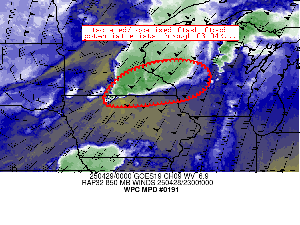
Mesoscale Precipitation Discussion 0191
NWS Weather Prediction Center College Park MD
1240 PM EDT Mon May 17 2021
Areas affected...Far Southeast TX...Far Southwest LA
Concerning...Heavy rainfall...Flash flooding likely
Valid 171636Z - 172300Z
Summary...Areas of flash flooding will be likely through the
afternoon across portions of far southeast Texas and southwest
Louisiana. Highly efficient hourly rainfall rates of 2-3" will
allow for additional localized accumulations of 3-6 inches.
Discussion...Flash flooding is currently ongoing midday across
portions of the Sabine River basin, including across the Beaumont
metropolitan area. A nearly stationary area of surface moisture
convergence has allowed for periodic episodes of deep convection,
producing large swaths of 4-8 inches of precipitation over the
past 6 hours (per MRMS QPE products). These radar estimations
appear to be reasonably accurate with little indication of hail
contamination via analysis of dual-pol radar components. The
Beaumont/Port Arthur Regional Airport (KBPT) measured nearly 7
inches of rain in the past 6 hours, which corroborates MRMS
dual-pol driven radar estimates. The latest radar trends and
hi-res CAM guidance suggest that episodes of heavy precipitation
will continue over this region over the next several hours,
propagating westward toward the Houston metro along with an
approaching, and potentially stalling, outflow boundary from North
Texas.
The aforementioned eastern portions of the outlined area (from
Lake Charles to Beaumont) will continue to see flash flooding with
a large area of 3-hr FFG values of 2 inches or less. Further west
where new convection propagates (from the Houston metro westward),
FFG ranges from 3-5 inches. Deep convection will continue to be
capable of 2-3" per hour rainfall rates, supporting localized FFG
exceedance in only a couple hours where convection is able to
repeat/train. Some training of convection does appear likely, as
an outflow boundary from North TX gradually stalls out over the
outlined area, providing a focal point for new convective
initiation amid a rapidly destabilizing air mass (SB CAPE rising
to 3000-4000 J/kg).
Churchill
ATTN...WFO...EWX...HGX...LCH...
Basically there's what would best be understood as a little front across SWLA and into far SETX. You have a lot of moist air converging at the surface, which keeps bringing in moisture. Convection should build west but at some point in SWLA it's rebuilding over and over again.
Then that outflow boundary over Texas will sag down and create the focus for the afternoon round (probably seeing it fire again pretty good by now I'd imagine) with some big instability numbers (yields lots of lightning, extreme rainfall rates at times, and a quick spin-up or two) to fuel it.
Posted on 5/17/21 at 2:25 pm to stout
You going to raise it?
Posted on 5/17/21 at 2:25 pm to zsav77
Rolling down Ham Reid Road and you can’t see a blade of grass around these houses. This is devastating!
This post was edited on 5/17/21 at 2:26 pm

Posted on 5/17/21 at 2:29 pm to sledgehammer
Time to start drinking.
Heavily.
Best of Luck to all impacted.
Heavily.
Best of Luck to all impacted.
Posted on 5/17/21 at 2:30 pm to sledgehammer
Holy shite I just had a lightning hit maybe 200 yards from me. It killed off my internet and TV momentarily. All the cows in that field took off to the other side of the pasture. That actually made my heart skip a beat.
The golden nugget also got hit with lightning sometime today. It shut down the entire kitchen and they've closed up the restaurants.
The golden nugget also got hit with lightning sometime today. It shut down the entire kitchen and they've closed up the restaurants.
This post was edited on 5/17/21 at 2:34 pm
Posted on 5/17/21 at 2:30 pm to jimbeam
quote:
You going to raise it?
I might if I can get some Fema money to do it like everyone else.
I could be wrong. It could be high and dry. It hasn't actually flooded in years and didn't flood during the hurricanes. I can't get across town to go look at it, though.
Posted on 5/17/21 at 2:32 pm to Linkovich
quote:
ETA: It’s a tenth of an inch from getting in both doors though.
Damn Link. Sorry to hear that. I am getting worried too. If it doesn't stop it will be at my front door with the hour.

 Page 7 of 66

Popular
Back to top