- My Forums
- Tiger Rant
- LSU Recruiting
- SEC Rant
- Saints Talk
- Pelicans Talk
- More Sports Board
- Fantasy Sports
- Golf Board
- Soccer Board
- O-T Lounge
- Tech Board
- Home/Garden Board
- Outdoor Board
- Health/Fitness Board
- Movie/TV Board
- Book Board
- Music Board
- Political Talk
- Money Talk
- Fark Board
- Gaming Board
- Travel Board
- Food/Drink Board
- Ticket Exchange
- TD Help Board
Customize My Forums- View All Forums
- Show Left Links
- Topic Sort Options
- Trending Topics
- Recent Topics
- Active Topics
Started By
Message
re: SW LA getting rocked by severe storms this morning.
Posted on 5/19/21 at 10:23 pm to Impotent Waffle
Posted on 5/19/21 at 10:23 pm to Impotent Waffle
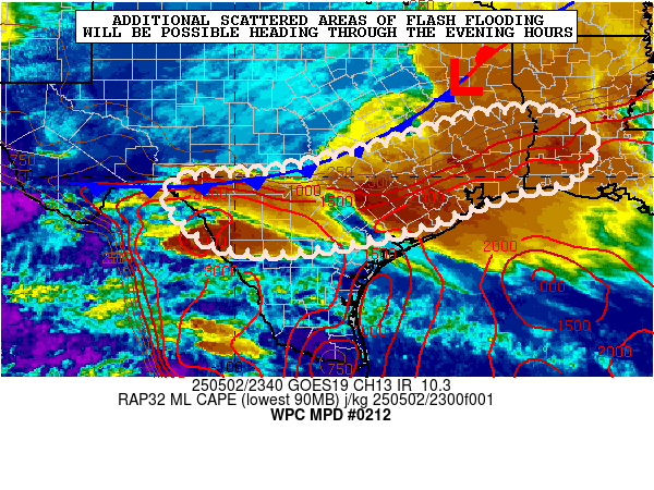
Mesoscale Precipitation Discussion 0212
NWS Weather Prediction Center College Park MD
906 PM EDT Wed May 19 2021
Areas affected...Upper Texas Coast to Southwest Louisiana
Concerning...Heavy rainfall...Flash flooding likely
Valid 200042Z - 200630Z
Summary...After a short respite, flash flooding looks to
re-develop throughout the evening and persist into the overnight
hours from the Upper Texas Coast into southwest Louisiana as a
deep fetch of moisture gets drawn back into the region ahead a
meso-scale area of low pressure.
Discussion...Satellite and radar imagery was showing an extensive
area of moderate to heavy rainfall off the Texas coast, but it was
starting to get drawn back inland during the late afternoon and
early evening by a deep-layer of southeast flow circulating around
high pressure over the eastern U.S.. Thus, another round of heavy
rainfall on already water-logged of Texas and Louisiana is setting
up for renewed flash flooding.
Satellite imagery was showing that cloud tops over the Gulf of
Mexico were cooling as low- and mid-level flow began to steer the
convection inland. The past few HRRR runs have focused 2 to 4
inch amounts per 6 hours ending at 07Z mainly in Texas. Based on
trends in radar imagery, suspect the area of heaviest rainfall
will be wider than depicted in the HRRR and be drawn farther
inland...with some maximum amounts of 6 or 8 inches. Even so,
think the HRRR has the best handle on the evolution of the system
throughout the evening and overnight hours.
Given the recent heavy rainfall events which have impacted the
area in the past 48 hours or so, flash flooding appears to be
likely. Areas most likely to be impacted are east of Galveston
Bay...which has tended to have the most rainfall over the past few
days. The risk of flash flooding extends into northern Louisiana
where the moisture gets channeled by flow around a synoptic scale
system farther north.
Present indications are that the risk of excessive rainfall will
continue beyond 0630Z.
This post was edited on 5/19/21 at 10:24 pm
 3
3


Posted on 5/19/21 at 10:26 pm to Duke


Posted on 5/19/21 at 10:41 pm to LaBR4
What's happening on the LA/TX border is insane.
Posted on 5/19/21 at 11:20 pm to Duke
HRRR did pretty well on it. It pretty much nailed it on the 18Z run yesterday at this point. Unfortunately, it is still showing that stall and pull Nortwhard over SE Louisiana later.

Posted on 5/19/21 at 11:43 pm to LegendInMyMind
Do we need to be worried in Baton Rouge?
Posted on 5/19/21 at 11:59 pm to NewIberiaHaircut
quote:
What's happening on the LA/TX border is some bull shite.
FIFY

Posted on 5/20/21 at 12:04 am to Duke
Tim McGraw Country has stayed amazingly dry through this.
Posted on 5/20/21 at 12:05 am to NewIberiaHaircut
I'm so tired of this shite. I'm literally exhausted from the past 8 months of extreme weather here in SWLA. I'm hoping to wake up from this horrible cycle of stressful and devastating events. It makes it very hard to live a normal life.
Posted on 5/20/21 at 12:15 am to The Boat
quote:
Tim McGraw Country
You just can't help yourself.
Posted on 5/20/21 at 12:19 am to The Boat
quote:
Tim McGraw Country has stayed amazingly dry through this.
You would have thought today would have had something. Instability and high pwats were nosing well into Arkansas.
Posted on 5/20/21 at 12:21 am to Duke
quote:
Can't imagine a weather thread without such astute observations
I've been flying since 1985 all over the world. You deal with it. It's not the end of the world unless you have never been outside of Sulphur. You hokey frick.

Posted on 5/20/21 at 12:25 am to Duke
I’m just glad BR was spared yesterday and today 
This post was edited on 5/20/21 at 12:25 am
Posted on 5/20/21 at 12:26 am to Aspercel
Not sure about that. BR might be getting some action in the next couple hours.
Posted on 5/20/21 at 12:28 am to GardenDistrictTiger
quote:
I've been flying since 1985
Old fricker.
quote:
You deal with it. It's not the end of the world unless you have never been outside of Sulphur.
Again, hard to know what to do without your invaluable contributions. Weather does in fact happen and sometimes you do have to deal with it.
quote:
You hokey frick.
It's enough to make you miss 08. Almost.
Posted on 5/20/21 at 12:32 am to fightin tigers
That line at least looks to be moving. Hopefully it won’t stick around.
Duke?
Duke?
Posted on 5/20/21 at 12:36 am to Aspercel
quote:
I’m just glad BR was spared yesterday and today
BR and SELA in general were always supposed to on the edge of the rain anyway.
It was a freak thing Monday night where you had some small scale factors lead to a little low pressure forming over the greater St. George Metroplex and pump out crazy amounts of rain.
The big picture set up was always for multiple rounds in SWLA, with it being more of a crapshoot in SELA as to who gets how much rain what day.
ETA:
The line is moving but with flow out of the ESE, it's probably going to get slowed down at some point but it'll also lose some bite away from the best, let's call em "rain dynamics" to the west.
I'm about to check the 00z high res stuff to see what kind of signal it's showing for SELA
This post was edited on 5/20/21 at 12:39 am
Posted on 5/20/21 at 12:41 am to Duke
Thanks
Y’alls weather threads can be very helpful.
Don’t tell 08 I said that.
Y’alls weather threads can be very helpful.
Don’t tell 08 I said that.
This post was edited on 5/20/21 at 12:43 am
Posted on 5/20/21 at 12:46 am to Duke
Yeah, so everything is holding that line up somewhere and having it train for a few hours, but while enough to do some nuisance flash flooding as low as the flash flood guidance is down there; I don't see the huge totals of Monday night popping up.
Only one of those high res models has it getting through to BR (HRRR) and it stalls it just off the coast. The other ones stall it just west or over Lafayette. Given what I'm seeing off RAP analysis at the low levels and where the upper level divergence seems parked, I think it holds up near or west of Lafayette.
Might get to BR, but I think it'll really be fading.
Posted on 5/20/21 at 12:46 am to Duke
quote:
greater St. George Metroplex
Someone need to change their location to this
Posted on 5/20/21 at 12:48 am to Duke

 Page 63 of 66

Popular
Back to top